
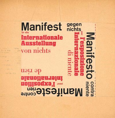
Manifest gegen Nichts ur die Internationale Ausstellung von Nichts. Manifesto contra Niente per L’Esposizione Internationale di Niente. Manifeste contre Rien pour l’Exposition Internationale de Rien
Hamburg.- Galerie Grundweg A single page broadsheet for an exhibition printed in red and black on cream-colored paper stock with typography in various font sizes by Onorio, and the text in each language oriented in a different direction on the page. 11 5/8 inches by 11 7/8 inches, folded to 8 1/2 by 8 1/2 inches. Loose as issued. Creasing, light browning to paper, overall very good. Hamburg/Basel, 1960. This broadsheet was published in conjunction with an "exhibition of nothing" organized by members of the Zero group, Fluxus members, and others. It consisted of an empty gallery with nothing for sale. The text on the broadsheet indicates that a price list of essentially nothing is available, and no one will be speaking at the opening of the exhibition. "Verkauft wird nichts, numeriert und signiert. Preisliste liegt aus. Zur Eröffnung spricht niemand." Participants included Carl Laszlo, Onorio, Rolf Fenkart, Bazon Brock, Herbert Schuldt, Piero Manzoni, Enrico Castellani, Heinz Mack, and Otto Piene. The exhibition caused a stir and was well-attended. In fact, the exhibition was held over to accomodate the large number of visitors. The manifesto states that the exhibition promotes Avantgardism, Conventionalism, Modernism, Conservatism, Communism, Capitalism, Patrioism, Internationalism, Monochromism, Monotonism, Zen, Surrealism, Dadasim, Lettrisme, Constructivism, Neoplasiticism, and Tachisme. As of February 2024, OCLC locates only two holdings in North America of this fascinating and notable document in the history of 20th century art.- $1,500
- $1,500
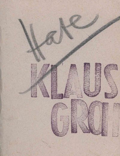
Two Miniature Artist’s Books: Love. Hate
Groh, Klaus Two small unpaginated artist's books, signed and dated by Groh. Each booklet 3 7/8 x 2 3/4 inches. Side-stapled gray cardstock, titles handwritten in pencil to front covers and Groh's name rubber-stamped, hand-signed and dated '87 in pencil to back covers. Extremely light soiling to covers, overall excellent. N.p, 1987. Klaus Groh (b. 1936) is a German artist and author who helped bring Mail Art from America to Europe and established an international Mail Art network. He directed the Micro Hall Art Center and the cabaret Literaturium as well as the International Artists' Cooperation (I.A.C.), the latter of which he ran from 1969 to 1990. These two miniature artist's books, titled "Love" and "Hate", are comprised of cut-up pages from a German telephone book, including some personal names and phone numbers as well as advertisements for businesses. They are unpaginated, each comprised of approximately 48 double-sided leaves. These two volumes are possibly unique; as of April 2024, there were no listings for either booklet on OCLC.- $650
- $650
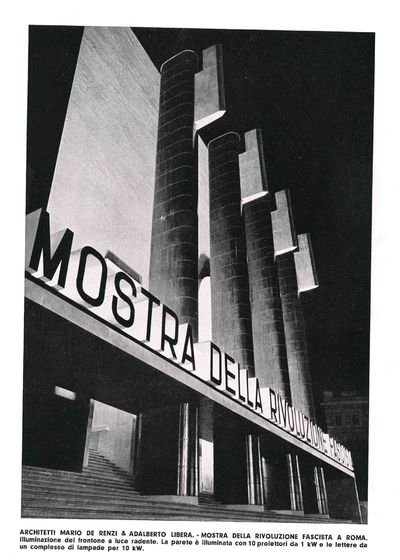
Architetture Luminose e Apparecchi per Illuminazione
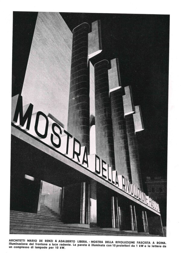
Canesi, Giovanni, & Antonio Cassi Ramelli (3), 162 pp. survey of the use of artificial lighting in modern architecture, profusely illustrated. Quarto (11 x 9 inches). Cloth boards with stamped title to cover. Light soiling and minor handling wear, overall very good. Milan (Ulrico Hoepli) 1934. Profusely illustrated survey of Art Deco and modernist lighting fixtures and both interior and exterior settings for lighting designed by 100 international architects, including Robert Mallet Stevens, Achille Donzelli, Mario Faravelli, Rudolf Fränkel, René Herbst, Erich Mendelsohn, André Salomon, Carlo Enrico Rava, Hans Poelzing, Aldo Viale, Alberto Strozzi, Paulo Buffa, Piero Bottoni, Edgar Brandt, Joseph Urban, and many others. The majority of the illustrations are from photographs, but some also show plans or elevations and other details. There are 216 illustrations total, including 128 of architecture and 88 of fixtures, most in public spaces and in buildings in which lighting is a key feature.- $500
- $500
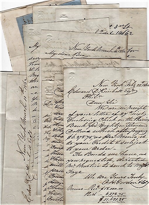
GROUP OF NINETEEN (19) LETTERS FROM GORDON TO EDWARD D. KIMBALL AND A FEW OTHERS, DATED 28 JANUARY 1862 TO 21 AUGUST 1862, INCLUDING THREE LETTERS WRITTEN TO GORDON, PLUS THREE (3) RECEIPTS
Gordon, O.H. The letters from Gordon are datelined New York. The receipts cover an Oregon War Loan, a deposit slip for Phenix Bank, NYC, and a quarterly statement of Kimball's account Gordon. Partial contents of the letters include: The Burnside Expedition; price and availabilty of Java Coffee; Chinese shipping; financial matters, stocks and bonds; Civil War news from the South and from the West; sleighing in Salem and Concord; $5,000 Oregon War Loan; US Government sending vessels south to Richmond "without delay"; &c.- $280
- $280
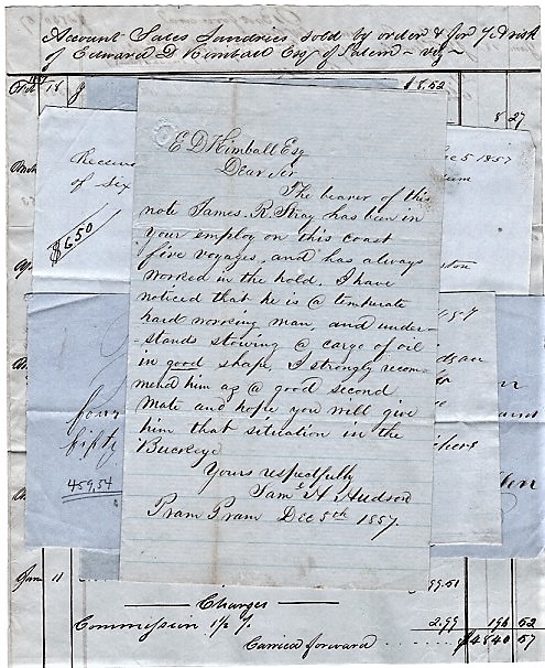
ARCHIVE: HANDWRITTEN LETTER, SIGNED, FROM PRAM PRAM [ACCRA, GHANA], ALONG WITH FIVE (5) OTHER HANDWRITTEN DOCUMENTS WRITTEN ca. 1857 FROM COASTAL AFRICA
Hudson, Capt. Samuel H. Six documents in all. The Hudson letter, addressed to E.D. Kimball, Esq., recommends James R. Stray for second mate aboard the ship "Buckeye," in part: ".[he's] been in your employ on this coast five voyages.he's a temperate and hard working man., Yours respectfully, Sam'l H. Hudson. Together with the letter are four handwritten receipts for Capt. Hudson's maritime trade in Accra, signed by Henry Richers, William Johnston and John Mullen. Also present is a two-page accounting manuscript of African cargoes sold by Edward Kimball: ivory, palm oil, camwood, &c., from the Barks "Buckeye" and "Louisa." All six documents in this small archive are from March-December, 1847. Five are datelined Pram Pram and Accra. The largest is 8" x 10"; the smallest 4" x 5". // Edward D. Kimball was a noted Salem, Massachusetts maritime merchant and shipping magnate. Although the focus of his trade was with the west coast of Africa, Kimball's vessels also sailed to the East Indies, the Pacific Islands, South America, Australia, and Asia.- $308
- $308
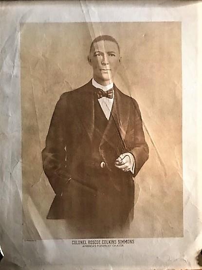
LARGE PHOTOGRAPHIC PRINT, CAPTIONED “COLONEL ROSCOE COLKINS SIMMONS / AMERICA’S FOREMOST ORATOR.”
Simmons, Roscoe Colkins Sepiatone print on old stock, a 3/4-length studio portrait of Colonel Simmons wearing a dark suit and vest, high white collar with silk bowtie, watch chain with pendant, large ring on his left hand, holding his spectacles. Image size, 13" x 10"; overall, 17" x 14". Margins toned; dust soiling on verso. Creases seen here were exaggerated by lighting, and are barely discernible on the original. "Roscoe Conkling Simmons (born 1878 or 1881, died 1951) was an African-American orator, civic leader, journalist and politician. He was graduated from Tuskegee Institute in 1899. He served as head of the Colored Division of the Speakers' Bureau of the Republican National Committee in 1920, 1924, and 1928. He was an advisor to three American presidents. He worked for the Chicago Defender from 1916 through the mid-1930s, and for the Chicago Tribune from the late 1940's until his death in 1951.The date of his birth is uncertain. Obituaries state his age in 1951 as anywhere between Simmons' own assertion that he was sixty-three and his oldest friends' statements that place his age nearer to seventy-five. A birth date of June 20,1878 in Greenview, Mississippi is listed in the earliest inventories of his papers produced by the Harvard University Archives. A passport appliction holds a 1918 certification of birth signed by his parents that state the year and place of his birth as 1881 in Macon, Mississippi." [Harvard Archives, dating this print as 1930."- $140
- $140

The Mariners Mirrour Wherin may playnly be seen the courses, heights, distances, depths, soundings, flouds and ebs, risings of lands, rocks, sands and shoalds, with the marks for th’entrings of the Harbouroughs, Havens and Ports of the greatest part of Europe: their several traficks and commodities: Together . Sr. Fra. Drake. / and: The Second part of the Mariners Mirrour .
Waghenaer, Lucas Janszoon and translation by Anthony Ashley First English edition printed in London. Two parts in one. Folio, 40 x 29 cm. With 2 engraved title-pages, an engraved dedication, a radial plate and the rare volvelle present in 2 separate plates (uncut). With 35 charts (of 45). Missing charts, in part I: 15, 16 & 17; in part II: 7, 12, 15, 18, 19, 20 & 21. The plates are by De Bry, Jodocus Hondius, Augustine Ryther and Johannes Rutlinger. Bound in a 19th century half leather binding. With some offsetting and some tanning but generally a good copy. Most of the maps and especially the title pages have a good dark impression. Provenance: Johan Harries, London [1590s] (ink inscription on title); M. Naylor (ex-libris) 20th century.- $80,707
- $80,707
Miscellaneous Poems.
Marvell, Andrew London: Printed for Robert Boulter at the Turks-Head, 1681., 1681. First edition without the suppressed Cromwellian poems as usual (pp.117-130). Folio. Engraved frontispiece portrait of Marvell, [iv] 1-116, 131-139. Contemporary full-leather binding. The front cover is detached (but present), there is a 1" chip bottom of spine. The frontispiece portrait is quite bright; there is a 3/4" x 3/4" chip top fore edge of "To the Reader" page not affecting the type. In general the text pages are bright and devoid of foxing. Internally the book is very good or better but given the detached cover, it is overall good.. 1st Edition. Hardcover. Good.- $8,500
- $8,500
Romantic Confusions of the Good. Beauty as Truth, Truth Beauty
Montgomery, Marion Lanham: Rowman & Littlefield Publishers (1997)., 1997. First printing. 8vo. xxxiv, 237 pp. Original black cloth binding without DJ as published. This is a tight, fine book. One of the more uncommon Montgomery titles.. 1st Edition. Hardcover. As New.- $120
- $120
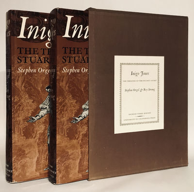
Inigo Jones. The Theatre of the Stuart Court. Including the Complete Designs for Productions at Court for the Most Part in the Collection of the Duke of Devonshire Together with Their Texts and Historical Documentation.
Stephen Orgel and Roy Strong Berkeley: University of California Press, 1973., 1973. First printing. Two volumes (complete). 1-2000 numbered copies, this being # 540. Very heavy, very large 4tos. Frontispiece illustration. 415 pp.; 418-843 pp. Profusely illustrated in B & W with, in addition, four colored plates. Original brown cloth binding in matching brown cloth covered slipcase with printed paper label. Both volumes are tight, fine in fine dust jackets; the slipcase has abrasions top and bottom of spine and one small area near the opening on the back panel - overall sound. Near fine. Very heavy, extra postage.. 1st Edition. Hardcover. Near Fine/Dust Jacket Included.- $350
- $350
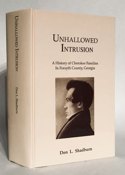
Unhallowed Intrusion. A History of Cherokee Families in Forsyth County, Georgia.
Shadburn, Don L. (Cumming, GA. Don. L. Shadburn, 1993). Second printing., 1993. Second printing. Limited to 500 copies. Thick 8vo. Frontispiece photograph. xi, 792 pp. Illustrated throughout. Original glossy illustrated tan boards, without DJ as published. This is a tight, fine book. Uncommon.. Hardcover. As New.- $400
- $400
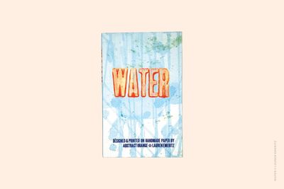
Water.
[Abstract Orange] Lauren Emeritz. Washington DC:, 2024. Washington DC:: Abstract Orange,, 2024.. Edition of 20 variants.. 7 x 11"; 48 pages. Letterpress printed on handmade paper. Bound in paper covered hard boards. Signed and numbered by the artist. Designed and printed by the Lauren Emeritz. Lauren Emeritz: "Following my 'Earth' book, I decided to make a book about another classic element: water. I learned paper-making, a process that uses a lot of water, so the book would use water as the previous book used UV light. The primary blue text in the book follows the flow of water in nature, from raindrops to streams, to rivers, to oceans, and back to the shore. That text overlaps distorted orange type representing other negative aspects of water, such as floods, acidity, disease, and drought. The work is meant to evoke the beauty of water, problems that arise from water, and how these things shape our lives. "The book … uses mineral spirits to dilute the orange ink, creating a painterly effect (inspired by the work of Helen Frankenthaler). The handmade paper in the book was painted with a blue paint wash. It is primarily cotton paper but uses some recycled fibers as well.- $1,500
- $1,500
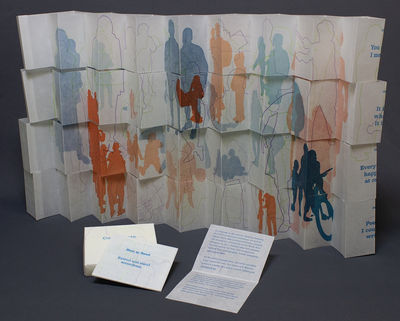
Constructs: You see, I mean or Everything Happens at Once or It Is What It Is or Poems I Couldn't Write (Volume 1).
Powers-Torrey, Marnie . [Salt Lake City]:, [2023]. [Salt Lake City]:: Marnie Powers-Torrey,, [2023].. Edition of 25. 4 x 3.75" paper formed lidded box with 4 x 3.5" clear plastic pieces laid at bottom of box and on top of book pieces to add stability. Retreating accordion structure. Line drawings and text letterpress printed from photopolymer plates. Solid silhouettes printed from laser-engraved wood blocks. Text set in Superclarendon. Paper waxed Masa. Signed and numbered by the artist. Marnie Powers-Torrey: "This interactive piece was made in response to the call for 'Seeking Balance', an invitational exhibition curated by Kayla Clark. The images are derived from photographs, mostly snapshots taken by the artist post-2000. The two 14" x 31" sheets were letterpress printed from photopolymer plates and laser-engraved woodblocks and then treated with beeswax. Each of the sheets was then cut down into four 3.5" high strips and folded into retreating accordions, a structure developed by the artist. The viewer/reader is invited to reconstruct the printed forms by matching segments of individual figures, stacking one folded form on top of another with the goal of constructing a balanced whole. "Figures who are contemporaneous and in an implied relationship, appearing in groups of two or more, are printed solid, suggesting bodies of land. Individual figures are represented as line drawings, alluding to travel routes over land, sea, or air, creating intersections which might be accidental or planned. The gestures and particularities of the silhouetted figures are singular in their subtleties and thus register as authentic humans rather than cookie cutouts. Still, the lack of distinguishable, identifying features produces a graphic, iconic quality which allows each viewer to apply personal experiences, make visual and conceptual connections, and construct individual narratives. The colors are vibrant and in conjunction with the layered, overlapping compositions convey a sense of overwhelmingness. The figures exist both on the same plane as well as within distinct three-dimensional spaces, connotating an urban living space. The various scales and hues imply receding space and variance in time, producing a confused hierarchy. In some moments, there seems to be rapport between individually printed figures while in others, tensions are insinuated. The subtitling references Lucy Lippard's 'I see, You mean' and Warren Lehrer's 'I mean, You know'.- $300
- $300
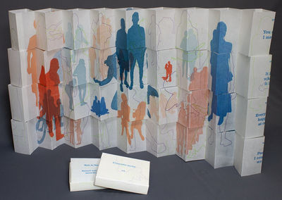
Constructs: You see, I mean or Everything Happens at Once or It Is What It Is or Poems I Couldn't Write (Two volumes).
Powers-Torrey, Marnie . [Salt Lake City]:, [2023]. [Salt Lake City]:: Marnie Powers-Torrey,, [2023].. Edition of 25. 4 x 3.75" paper formed lidded box with 4 x 3.5" clear plastic pieces laid at bottom of box and on top of book pieces to add stability. Retreating accordion structure. Line drawings and text letterpress printed from photopolymer plates. Solid silhouettes printed from laser-engraved wood blocks. Text set in Superclarendon. Paper waxed Masa. Signed and numbered by the artist. Marnie Powers-Torrey: "This interactive piece was made in response to the call for 'Seeking Balance', an invitational exhibition curated by Kayla Clark. The images are derived from photographs, mostly snapshots taken by the artist post-2000. The two 14" x 31" sheets were letterpress printed from photopolymer plates and laser-engraved woodblocks and then treated with beeswax. Each of the sheets was then cut down into four 3.5" high strips and folded into retreating accordions, a structure developed by the artist. The viewer/reader is invited to reconstruct the printed forms by matching segments of individual figures, stacking one folded form on top of another with the goal of constructing a balanced whole. "Figures who are contemporaneous and in an implied relationship, appearing in groups of two or more, are printed solid, suggesting bodies of land. Individual figures are represented as line drawings, alluding to travel routes over land, sea, or air, creating intersections which might be accidental or planned. The gestures and particularities of the silhouetted figures are singular in their subtleties and thus register as authentic humans rather than cookie cutouts. Still, the lack of distinguishable, identifying features produces a graphic, iconic quality which allows each viewer to apply personal experiences, make visual and conceptual connections, and construct individual narratives. The colors are vibrant and in conjunction with the layered, overlapping compositions convey a sense of overwhelmingness. The figures exist both on the same plane as well as within distinct three-dimensional spaces, connotating an urban living space. The various scales and hues imply receding space and variance in time, producing a confused hierarchy. In some moments, there seems to be rapport between individually printed figures while in others, tensions are insinuated. The subtitling references Lucy Lippard's 'I see, You mean' and Warren Lehrer's 'I mean, You know'.- $500
- $500
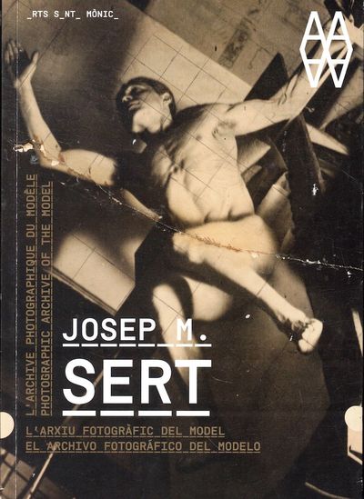
Josep M. Sert: Photographic Archive of the Model
Josep M. Sert, Vicenc Altaio, Maria del Mar Arnus, and Juan Naranjo Barcelona/ Madrid, 2011 Barcelona/ Madrid: Arts Santa Monica/ La Favrica Editorial, 2011. Paperback. Very good. Paperback. First Edition. 95pp. Lightly rubbed, else very good in publisher's French fold wraps. Text in English and Spanish.- $150
- $150
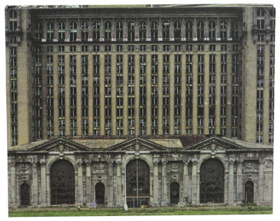
Yves Marchand & Romain Meffre: The Ruins of Detroit
Yves Marchand, Romain Meffre, Robert Polidori, and Thomas J. Sugrue Gottingen, 2010 Gottingen: Steidl, 2010. Hardcover. Very good. Hardcover. First Edition. 227pp. Very good hardback bound in publisher's photographically illustrated cloth boards and issued without a jacket.- $250
- $250
Architetture Luminose e Apparecchi per Illuminazione
Canesi, Giovanni, & Antonio Cassi Ramelli (3), 162 pp. survey of the use of artificial lighting in modern architecture, profusely illustrated. Quarto (11 x 9 inches). Cloth boards with stamped title to cover. Light soiling and minor handling wear, overall very good. Milan (Ulrico Hoepli) 1934. Profusely illustrated survey of Art Deco and modernist lighting fixtures and both interior and exterior settings for lighting designed by 100 international architects, including Robert Mallet Stevens, Achille Donzelli, Mario Faravelli, Rudolf Fränkel, René Herbst, Erich Mendelsohn, André Salomon, Carlo Enrico Rava, Hans Poelzing, Aldo Viale, Alberto Strozzi, Paulo Buffa, Piero Bottoni, Edgar Brandt, Joseph Urban, and many others. The majority of the illustrations are from photographs, but some also show plans or elevations and other details. There are 216 illustrations total, including 128 of architecture and 88 of fixtures, most in public spaces and in buildings in which lighting is a key feature.- $500
- $500
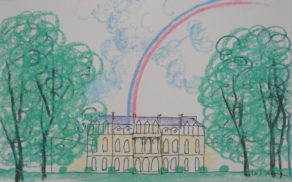
François-Xavier LALANNE : Palais de l’Elysée à l’arc en ciel, Sérigraphie signée
Art, Affiches et Gravure François Xavier LALANNE. - Palais de l'Elysée à l'arc en ciel, 1990. - Sérigraphie. - Signée dans la planche. - Sur vélin 13.5 x 21.5 cm . - (Dimension du feuillet déplié 13.5 x 43 cm). - Cette sérigraphie a été créée pour la carte de vux du Palais de l'Élysée (Présidence française, mandat de Jacques Chirac) de 1997. - En excellent état, pli médian peu marqué (tel qu'édité).- $133
- Artfever |
- $133
GENIUS AND THE MOBOCRACY
Wright, Frank Lloyd xiii,113pp. Quarto. Cloth. Plates. Bookplate, endsheets slightly tanned, with some slight tanning to the perimeter of the white cloth, but a very good copy, in good, moderately dust soiled, slightly chipped dust jacket with one short, internal mend. First edition of Wright's biography of Louis Sullivan, including reproductions of thirty- nine of Sullivan's drawings. SWEENEY 750.- $150
- $150
EZRA POUND HIS METRIC AND POETRY
[Eliot, T. S.] 31pp. Rose boards, stamped in gilt. Portrait of Pound by Gaudier-Brzeska. Spine somewhat sunned, gilt lettering with a slight patina, boards faintly dust-soiled, small bump toward crown of spine, but a very good, clean copy, without the usual foxing to the verso of the frontis. Lacking the plain tan paper shipping wrapper. First edition of Eliot's anonymously published second book, superintended by John Quinn as a promotional for LUSTRA. According to Gallup, one of one thousand copies printed -- however, the frequency with which copies turn up - particularly in light of the attrition rate one would expect for a book so delicate - can't help but suggest the edition may have possibly been a bit larger. GALLUP (ELIOT) A2.- $600
- $600
ANIMULA
Eliot, T.S., and Gertrude Hermes [illus] Pictorial wrapper. Two wood engravings by Gertrude Hermes. Small smudge on front wrapper near spine, otherwise near fine. First edition, trade issue, issued as Ariel Poem #23 (3000 copies printed). As often, this issue preceded the limited printing by almost three weeks. GALLUP A14a.- $100
- $100
![AN AUTOBIOGRAPHY [wrapper title]. BOOK SIX BROADACRE CITY [caption title]](https://rarebookinsider.com/wp-content/uploads/2024/05/31797887845-600x577.jpg)
AN AUTOBIOGRAPHY [wrapper title]. BOOK SIX BROADACRE CITY [caption title]
Wright, Frank Lloyd 32pp. Oblong small quarto. Printed wrapper. Vertical crease from having been mailed, light tanning and minor nicks at edges, else a very nice copy of a fragile book. Denoted a "Revised Printer's Proof" of a chapter intended for the revised 1943 edition of AN AUTOBIOGRAPHY, but not included therein and distributed in this form by Taliesin. There was another printing, on newsprint, dated Summer 1943, featuring differences in text and typographic arrangement. Accompanied by a t.l.s., [Np], 27 Aug. 1950, from Wright's secretary, Eugene Masselink, forwarding this copy, along with some other Taliesin papers, to an inquiring party. Uncommon and fragile. OCLC locates six copies, all in North America, as opposed to well over thirty for the "Summer 1943" printing. SWEENEY 2049. OCLC: 3738363.- $600
- $600
![[Original First US Release Standee for:] THE MAGIC CHRISTIAN](https://rarebookinsider.com/wp-content/uploads/2024/05/31796632148.jpg)
[Original First US Release Standee for:] THE MAGIC CHRISTIAN
Southern, Terry [sourcework] Original pictorial standee on stiff board (approximately 58 x 37"), folded to four panels, with folded supporting struts intact on verso. A few bumps to corners, folds and edges, blank verso a bit dusty and hand smudged, generally very good, displaying well from the pictorial side. An original pictorial lobby standee prepared to promote the U.S. release of Southern and Joseph McGrath's embellished adaptation of Southern's third novel. McGrath directed the British production, starring Sellers, Ringo Starr, Richard Attenborough, Laurence Harvey, Christopher Lee, Spike Milligan, Raquel Welch, et al. The film was released in the UK on 12 December 1969, with the US opening following on 11 February 1970. Peter Sellers, John Cleese and Graham Chapman contributed additional material to the script. Standees are typically produced in quantities far below the numbers of one and three sheets, and tend to be uncommon in the after-market. Oversized, requiring extra shipping costs.- $475
- $475

ON ARCHITECTURE SELECTED WRITINGS 1894 – 1940
Wright, Frank Lloyd Oblong thick small quarto. Cloth. Private bookplate on front pastedown. Usual slight tanning to endsheets, otherwise about fine in very good, or better, spine-sunned dust jacket, with the jacket price ($3.50) intact, and with a few minor nicks and smudges. First edition, edited, with an introduction, by Frederick Gutheim. SWEENEY 532.- $150
- $150
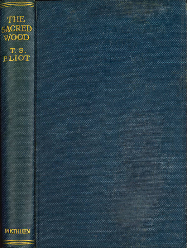
THE SACRED WOOD ESSAYS ON POETRY AND CRITICISM
Eliot, T.S. Small octavo. Gilt blue cloth. Some of the usual tanning to the endsheets, small ink name on free endsheet, slight rubbing and dulling to upper board, but a good, bright copy. First edition, third binding, with the 8pp. Methuen catalogue bound at the end. Gallup suggests that copies of the original sheets, in this binding, were distributed not earlier than January 1924. GALLUP A5a.- $115
- $115

POINTS OF VIEW
Eliot, T.S. Cloth. Usual tan offset to endsheets, otherwise a very nice copy in modestly sunned and lightly soiled dust jacket with residue of three old internal edge mends. Edited by John Hayward. First collective edition (4000 copies printed). This copy just may have been inscribed by the editor on the half-title: "Reg from J." GALLUP A38.- $100
- $100
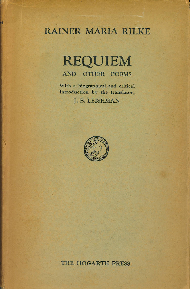
REQUIEM AND OTHER POEMS
Rilke, Rainer Maria 147pp. Errata slip. Cloth. Portrait. Bookplate on front pastedown, with typical foxing to end leaves, otherwise very good in somewhat tanned and lightly nicked and chipped dust jacket. First edition of these translations by J.B. Leishman. Printed in an edition of 1075 copies. WOOLMER 375.- $250
- $250

The Central Route from Chicago to San Francisco is 500 Miles The Shortest
[Western Americana - Railroads] Chicago and North-Western Railroad Chicago, 1882 Chicago: Rand, McNally and Co, 1882. Lithographic broadside illustration printed in color measuring 11 x 5 ¾ inches. Closed tear to margin, paper reinforcement to corners verso, very good condition, quite bright and attractive. Very Good. An attractive advertisement for the Chicago and North-Western's routes to San Francisco, printed during the tenure of the railroad tycoon Marvin Hughitt as General Manager, a position he held from 1876 to 1880 before being named Second Vice President. The advertisement was printed by Rand, McNally and Company, which in its early years focused on railroad-related materials. The Omaha and California line of the Chicago and North-West Railway connected passengers from Chicago to California. Other maps printed by Rand, McNally and Co. during the period illustrate the route. We find no other examples of this broadside.- $950
- $950
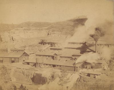
Four Mounted Photographs of Deadwood and Lead City, South Dakota
[Western Americana - Photography] Locke, Henry Robinson Deadwood, 1890 Deadwood: H.R. Locke, 1890. Albumen photographs measuring 9 x 7 inches on larger mounts. Very good contrast, some chips and wear to mounts. Very Good. A group of four photographs by Henry Robinson Locke, who operated a studio in Deadwood, South Dakota in the early statehood years. He photographed the Black Hills region. This collection of four photographs shows a gold mill in Deadwood, a cyanide mill in Deadwood, and two views of Lead City, which was the home of the Homestake Mining Company during the period, and continued to be a center for natural resource extraction for several decades following the initial Gold Rush period of the 1870s which brought the first wave of Euro-American settlers to the area.- $1,500
- $1,500
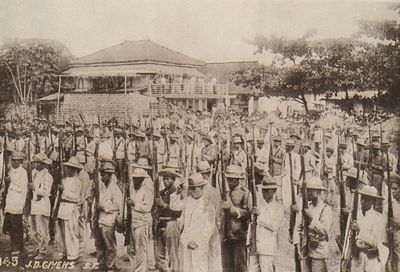
Scenes in the Philippines / Cuba….. / Porto Rico / The Hawaiian Isands / And scenes Relating to Soldiers. J.D. Givens, Photographer / San Francisco, CA. [Supplied Title] [251 Half-Tone Photographs of the Philippine-American War]
[Philippine-American War - Photography] Givens, James D.; Rockett, Perley Fremont San Francisco, 1905 San Francisco, 1905. Loose photographs in box, images measuring 5 x 7 inches. 251 Half-Tone images, generally fine condition, box torn with missing panel. Fine images and good-only box. Fine. James D. Givens had a studio in San Francisco's Presidio for many years, and traveled to the Philippines in 1903 on an Army transport ship, where he took photographs of the Philippine-American War. This collection, with Givens' studio's imprint on the box, contains a mix of Givens work as well as many photographs by Perley Fremont Rockett, and many photographs by uncredited photographers, copied and sold by Givens without attribution. According to an article in the Spring, 2002 issue of Prologue, Givens would publish several different later books claiming credit for other photographers' work. This collection - of which we find no record, save for a similar assemblage with a different title housed at Stanford - seems to be earlier, likely pre-1905. Despite the title on the box, all but a couple of images show the Philippines. The numbering system at work in the photographs is inconsistent, with some of Givens' images having their own numbering system different from the typed captions, and Rockett's images with different numbers in the negative. This collection contains 251 images, whereas Stanford's contains only 229, though due to the numbering inconsistencies we cannot collate for completeness. Regardless, a rare and interesting collection of images of the conflict, with the violence on graphic display and many images showing domestic Filipino scenes.- $1,500
- $1,500
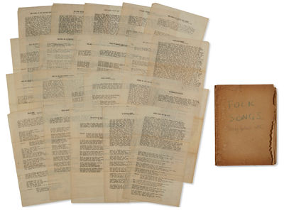
An Archive of Songs, Some Annotated, and a Partial Draft of Guthrie’s Hard Hitting Songs for Hard Hit People from the Collection of Harold Ambellan, Guthrie’s Collaborator and Benefactor
[Music - Folk Music] Guthrie, Woodrow Wilson; Ambellin, Harold New York, 1940 New York, 1940. Eighty-five pages, including sixty loose pages and a partial draft of Guthrie's Hard Hitting Songs for Hard Hit People, totaling twenty-five pages. With one handwritten page. One page - a typewritten copy of "The Ballad of Harry Bridges" - with a handwritten note by Guthrie to Ambellan. With photocopies of several letters from Guthrie to Ambellan included. Also with a broadside of the Carol Tree Carol by Alan and Elizabeth Lomax (1940) and a notecard with the lyrics to "Hawl Away Joe" written Inscription states "Here you are Harold, hope it aint late. Well if it is will be singing about old Harry for a many a day to come. Pour it on em, Boy. Woody G. A fascinating collection of material from the collection of Harold Ambellan, Woodie Guthrie's friend, collaborator and landlord during an important creative period for Guthrie in the 1940s. The group contains a partial draft of Guthrie's Hard Hitting Songs for Hard Hit People, which was written while Guthrie was living in Ambellan's loft, as well as a collection of over sixty loose songsheets not included in the book. Of these, over thirty are not listed in Tulsa's Woody Guthrie Center finding aid. The sixty pages include variant titles and verses to recorded and published versions, with some items attributed to Ledbelly, and overall the group should shed light on scholar's efforts to map out the landscape of the American folk song at the time of Guthrie's work. The typescript draft generally matches the published version, with the occasional typo. Nora Guthrie writes in her introduction to Hard Hitting Songs of the influence of Ambellan on Guthrie's creative process. Ambellan was an artist and sculptor and part time musician, and Guthrie lived in Ambellan's loft on 21st Street. "The loft was mostly filled with Ambellan's sculptures, which were abstract and very large. However, the couple managed to throw a cot up in the back of the loft for Woody to crash on... Evenings at the loft often included impromptu hootenannies, where Woody and Pete's [Seeger] musician friends would gather to raise some money to help pay the Ambellans' rent... There was a lot of singing, and a lot of songwriting, and it was in the 21st Street loft that Hard Hitting Songs came into existence." Guthrie wrote "Vigilante Man" and "Hard Travellin" while staying at the Ambellans' loft. Nora Guthrie continues: " Alan Lomax's father, John Lomax, had collected a group of songs that dealt with migrant workers', share crop farmers', and industrial workers' issues, many of the lyrics protesting workers' conditions and advocating for their rights. At the time, the material was considered 'too hot to handle' by government employees, so Alan handed it over to Pete [Seeger] and Woody to browse through. They loved the material and together with Alan, they decided to create a new songbook they would embellish with their own writings and commentary, as well as some additional original songs. Working fourteen hours a day, they completed the songbook in about five months. [...] The manuscript, which they had titled Hard Hitting Songs for Hard-Hit People, was left behind in the loft, literally saved by Elisabeth Higgens until its existence became known in the 1960s, when it was first published in 1967." Overall a very scarce relic of an important period in Guthrie's career with a fantastic association. Guthrie ephemera and archival pieces are notoriously scarce on the market, with single letters occasionally surfacing.- $12,500
- $12,500
A Long Account of a Violent Attempt to Occupy Land in Chihuahua by a Canadian Citizen Working for a Plumas County-Based Mining Company, 1883
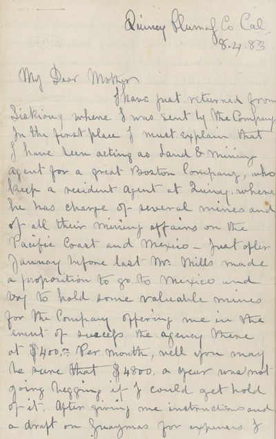
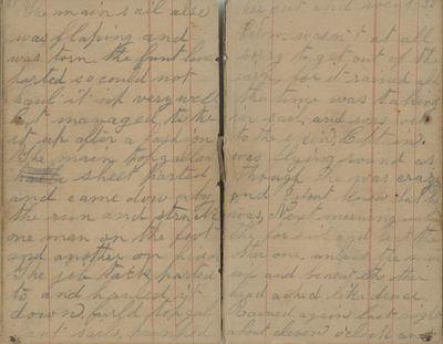
[Mexico - Land Schemes - Mining - California - Misdeeds] Unknown Author Quincy, 1883 Quincy, 1883. 8 x 6 inches. Twenty page letter by an unknown author written to his mother. Some tears, quite legible, very good overall. Very Good. [Warning - this description contains violent content and racist language] A long, highly unusual and and descriptive letter written by an employee of a mining company based in Quincy who leaves San Francisco for Guaymas before heading into the mountains on a very violent journey in which he attempts to occupy land in the hills outside of Guaymas based on an incorrect assumption that his Canadian citizenship will allow him to circumvent Mexican laws regarding American seizure of land. After getting arrested and possibly extorted by Mexican forces, he is eventually freed when a British captain finds him and persuades the Governor to formally charge him with a crime. He is acquitted in court in Chihuahua, and closes the letter by lamenting the lack of opportunity in California and the United States more broadly, as he is eventually sent back to California unsuccessful in his endeavors. He begins the letter by describing his employment by a Plumas County-based company, which we are unable to identify, before describing his arrival in Guaymas and the trip into the mountains. He writes, "I hired a couple 'hard cases' to take charge and look after the greasers - I had 20 of them - as a guard. Of al. the incorrigible lot of thieves and cutthroats commend me to the average Mexican for the first three days out we had to keep watch... to prevent the scoundrels from deserting with the whole train and goods, but after we got them in the mountains we had more control over them, particuarly after Maxwell one of my white desperadoes caught "Jesus" (every other Lousy Indians named 'Jesus' or after some other saint) trying to sneak off the fifth night with his mustang and two pack mules, for he took a short way of stopping him, which was simply shooting him. This had a good effect on the other fellows." After he arrives at his destination in the mountains - in an unnamed town, he then describes building a "fort or hacienda... so that in case of attack I could make a good fight or 'hold the fort.'" After sending notice of his arrival to Guaymas, a brigade of soldiers arrives to arrest him based on charges of "[taking] possession of Mexican soil, [building] a fort and [holding] it with armed men." He is then imprisoned in his house and put under guard, and though he thinks he could have bribed any of the guards and escaped to Guaymas and back home, he does not due to the three thousand dollars of the company's money deposited at the "German bankers" in Guaymas. Choosing to stay, he writes a letter to the agent at Quincy, which is burned by the guard. He writes another letter, puts it in a bottle with directions for a carrier, and positions his hammock at the edge of his fort, waiting to pass the letter to someone outside the walls. His chance comes when a number of British ships enter the port and he is able to pass his note to a commander of the HMS Comus while visiting the town square with his captors. The captain of the ship, possibly James East, eventually has a meal with the author and his captors, making inquiry into the author's detention a the hands of the Governor. He writes, " the captain gentrly requested a little explanation from his Excellency as to my detention for months without a charge being made against me... his excellency of course was much astonisthed that my letters had never reached their destination, that was the only reason that I had been detained (of course the old rascal did not hint at the $3000 which he had hoped I would have given him long ago...)." The Captain is successful in securing the author's freedom, at which point the author returns to Guaymas and eventually takes up residence in the house of the banker, a Mr. Goldberg, who is holding the company's funds. He writes to his company in California, and awaits formal charges from 'Don Cavallo,' which eventually arrive. He leaves for Chihuahua and is "met with quite a crowd of English-American and Californians, who were quite ready to back [him] in anything [he] wished..." He is charged with illegal seizure of land, and states in the letter that he had been under the impression he had allowed to take it as he was not a resident of the United States but instead "had sworn allegiance to Victoria (it is later revealed that he is Canadian). It becomes clear that the company had attempted to use him in this land grab plot due to his not being a US citizen. The court dismisses his case and returns his money, stating that he had been ignorant of the law, after which he returns to California and explains the situation to his bosses, who put him on a different case involving a quartz mine. He is saddened by his inability to make money and relates this to his mother, stating "I am getting used to failure to make money, after all I do desire great riches for myself as my tastes are simple enough if I became a California Banana King tomorrow I would probably be in the interior of Africa in six months, I would like to get some money for you though..." The letter ends with talk of friends and family back home in Canada. The author offers the following advice to a family member considering coming to California, "if he has not money sufficient to start in some business, or to take him out of the country again he will be sorry that he ever came. If he wishes to waste a dozen years of his life in learning a totally new way of living let him come. But let him go to Montana he will bet all he wants of a new country there. California is fearfully overcrowded with fellows from the east allured by stores of sudden acquired wealth, where one succeeds 1000 fail. California is after all a poor country." He signs the letter as John. Overall a fascinating account of a failed attempt at a land grab by a Canadian citizen working for a California mining company in Plumas County - unusual in its detail and scope.- $1,500
- $1,500
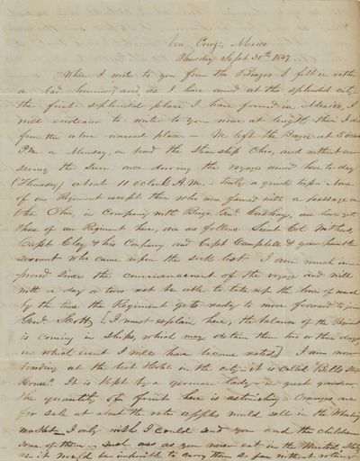
Lengthy Letter Describing the Food and Scenery of Vera Cruz, Written by Captain George Clutter of Wheeling, [West] Virginia, Captain of the the ‘Mountain Boys of Monongolia.’
[Mexican-American War - Correspondence - Food] Clutter, George Vera Cruz, 1847 Vera Cruz, 1847. Folded letter to Wheeling, Virginia with learly struck two-line datestamp with "Paid 10" manuscript rate and blue "Steam" handstamp of New Orleans on 1847, with an unusual "Steam" marking applied in New Orleans. Fine condition. Fine. A descriptive and interesting letter from Captain George W. Clutter of Wheeling, Virginia, describing the scenes and food in Vera Cruz in detail. Clutter had enlisted a detachment of thirty-two men in early 1847 in Monongalia County for service in the war, who would eventually become known as the "Mountain Boys of Monongalia." Clutter was promoted to the captaincy upon the resignation of John Tyler. The company sailed in June of 1847 on the Brig "Tuckahoe" from Old Point Comfort to Point Isabel, where they marched to join General Taylor's forces. This interesting letter, written by Clutter from Vera Cruz, describes the city and cuisine of Vera Cruz in detail. He writes, "I am now boarding at the best Hotel in the city - it is called "Bells Stage House'. It is kept by a German lady, in great grandeur. The quantity of fruit here is astonishing. Oranges are for sale at about the rate apples would sell in the Wheeling market. I only wish I could send you and the children some of them - such ones as you never eat in the United States, as it would be impossible to carry them so far without rotting. As we get dinner here at 3 o'clock and no such thing as supper is known, I stepped out this evening and obtained a 'cup of chocolate' and 'toast'. If an American (or rather United States) cook could taste such chocolate as the Mexicans make, they never would attempt making the article again - and it is not so much in the simple making of the chocolate, but it's in preparing it at the start - for every family, even the provost, understands making the article from the Cocoa." Clutter offers additional details on troop movements and logistics of the campaign. Other letters by Clutter during the period are held at the West Virginia Regional History Center at WVU. Full contents follow: Vera Cruz, Mexico Thursday Sept. 30th 1847 When I wrote to you from the Brazos, I felt in rather a bad humor, and as I have arrived at this splendid city, the first splendid place I have found in Mexico, I will endeavor to write to you more at length than I did from the above named place. We left the Brazos at 5 o'clock P.M. on Monday, on board the Steamship Ohio, and without ever seeing the sun once during the voyage, arrived here today (Thursday) about 11 o'clock A.M. - truly a quick trip. None of our Regiment, except those who were favored with a passage on the Ohio, in Company with Brig. Genl. Cushing, are here yet. Those of our Regiment here, are as follows: Lieut. Col. Withers, Capt. Clay & his Company and Capt. Campbell & your humble servant, who came upon the sick list. I am much improved since the commencement of the voyage and will with a day or two's rest be able to take up the line of march by the time the Regiment gets ready to move forward to join Genl. Scott. [I must explain here, the balance of the Regiment is coming in ships, which may detain them two or three days, in which event I will have become rested]. I am now boarding at the best Hotel in the city - it is called "Bells Stage House'. It is kept by a German lady, in great grandeur. The quantity of fruit here is astonishing. Oranges are for sale at about the rate apples would sell in the Wheeling market. I only wish I could send you and the children some of them - such ones as you never eat in the United States, as it would be impossible to carry them so far without rotting. As we get dinner here at 3 o'clock and no such thing as supper is known, I stepped out this evening and obtained a 'cup of chocolate' and 'toast'. If an American (or rather United States) cook could taste such chocolate as the Mexicans make, they never would attempt making the article again - and it is not so much in the simple making of the chocolate, but it's in preparing it at the start - for every family, even the provost, understands making the article from the Cocoa. In this City may be seen all the fashionable, fine buildings and streets to be found in any city of the United States. Also, all the various, fancy and other goods now in the cities of the North & East can be found here. I have not yet found another horse since my arrival, but must try and get one tomorrow. I hope my friend Pollock will receive the Mexican roan, 'J.B.' which I sent him from Brazos. From hard usage he is not in very good order at present, but with little care will be a very useful horse. Don't you ever ask the privilege of riding him, however. Mind I know him well. As you have heard before this, Genl. Scott is in the City of Mexico, having sustained a very heavy loss in getting there. We expect to have considerable fighting between here and the City of Mexico ourselves. Time, however, will reveal all things. The soreness in my legs which I complained of is better, but I fear exercise will cause it to return. What it will terminate in I am unable to say at present. I received a letter from you at this place today, which was read with the usual interest, notwithstanding it was written on the 13th August, 17 days previous to the last one received at Sabinito, which was dated 30th August. I have just bought five Vera Cruz papers, which I will send you. They are half Mexican, which half you can dispose of as you see proper. By the bye, Mr. Fleeson promised to send you the Matamoros Flag regular. Tell me if you get it. Oct. 1st 1847 This morning I have been all over the city. It would take me a month to describe all the curiosities I have beheld. I will save that for a private chat some long evening, after my return. I would like to have you, Dear little Ada, to examine and see the curiosities to be seen. When papa comes home he will bring you some of them. My love to Sarah Ann. I would write longer to her had I time. My love to all my friends & acquaintances. I am Dearest Sarah your loving husband Geo. W. Clutter [to] Sarah M. Clutter.- $950
- $950
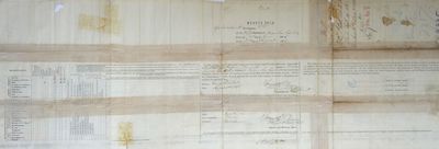
Muster Roll for Company B of the First Battalion, Native Cavalry California Volunteers [“Californio Lancers”] – Aug. 31, 1865
[Mexican - Americana, California - Civil War - California Native Cavalry] Camp Low, 1865 Camp Low, 1865. Original partially printed document, 26cm x 77cm. Printed on both sides of the sheet, completed in manuscript. Darkening at folds from old tape repairs; partial splits to folds and extremities; complete and quite Good. Docketed verso, signed in ink by Lieutenant M[organ?] Owen. Lists twelve enlisted soldiers, most with Spanish surnames (two with French surnames). Fine. The formation of the California Native Cavalry in 1863 marked a significant chapter in the state's history. Comprising primarily Mexican-American individuals, colloquially referred to as "native" Californians, the California Native Cavalry unit was formed 1863. Initially commanded by Maj. Andreas Pico, a distinguished hero from the Mexican-American War, and later under Salvador Vallejo, the regiment drew its ranks from diverse backgrounds. Recruitment efforts began with vaqueros from southern California, expanding to include individuals from San José and San Francisco. The unit boasted a varied composition, encompassing not only Mexican-Americans but also Chilenos, California and Yaqui Indians, and even French legionnaires. Company "B," a contingent largely recruited from the northern part of the state, is reflected in the existing muster roll. The company assembled at Camp Low near San Juan Bautista in 1865, making a striking entrance into the town. Described as "gay and gallant Spanish lancaroes," the cavalrymen presented a formidable sight with lances in hand and flags flying, leaving a lasting impression on the townspeople who had never before encountered soldiers."The gay and gallant Spanish lancaroes [sic] came dashing through the town with the lances in their hand, a flag flying from each of them. I assure you that they presented a war like appearance, the people here had never seen a soldier in their lives - Yes Sir!.." (letter, Maj. Michael O'Brien to Gov. Frederick Low, January 1865; quoted in Prezelski, "Lives of the Californio Lancers: the First Battalion of Native California Cavalry" in Journal of Arizona History, v.40, no.1 (Spring 1999). Under the command of Capt. Porfirio Jimeno, Company B swiftly engaged in a critical mission: dismantling the notorious Mason-Henry Gang that had terrorized the San Juan region in the preceding months. Despite successfully wounding John Mason in early April 1865, the gang persisted for another month until Mason met his demise at the hands of a miner he sought to kidnap. However, Company B faced challenges, including low morale and a high rate of desertions, with over 40 men leaving the company in 1865 alone. Transferred to Tubac, Arizona Territory, to confront the Apaches, the company encountered further desertions along the way. The muster roll, listing only twelve soldiers alongside Capt. Porfirio Jimeno, reflects this tumultuous period. Overall the muster roll provides scarce documentation of the role of Mexican-Americans in the Civil War, with few other examples in the trade or institutionally.- $4,250
- $4,250
A 19th-century Seafaring Shantyman’s Daybook Kept on a Journey to Brazil on a Steam Frigate
[Life at Sea - 1860s - Brazil - Musicology] Littlefield, Otis Massachusetts, Brazil, et al., 1861 Massachusetts, Brazil, et al., 1861. (Newport, England; Bahia, Brazil; Vp, MA and ME; Charleston, SC): (April 20, 1860 - March 1, 1861). Large 16mo (3" x 5"; 76 x 127mm). Pocket journal(s) in marbled self-wrappers rebound in contemporary or old boards; front board absent, back board present but detached, scuffed, bumped, and rubbed. 48 leaves machine-ruled paper, paginated in pencil, comprising approx 82pp mss text recto-verso also in pencil; original marbled self-wrapper and first signature detached from a shaken text block, internally uniformly toned with some smudging. Manuscript contains text of three (3) 19th-century sea shanties, some of which showing possibly unattested verse variants. Good. In this journal, American mariner Otis Littlefield vividly documents one important phase of his career as a rigger on a 19th-century transatlantic shipping vessel. He names himself as author at the outset, and announces the scope and purpose of his narrative: "[This is] the journal of Otis Littlefield showing some of the events that transpired on his passage from Newport, [England], to Bahia in Brazil on board the ship Tranquebar [under Captain] Goodwin. We sailed Friday, 20 April [1860]. It is called an unlucky day...." In what follows, Littlefield does not only describe his passage to Brazil; instead, he also records his subsequent northbound voyage to America, with port calls in Bath, ME, and Charleston, SC, respectively, and his final return voyage to England early the next year. Apart from Littlefield's proem, there is only limited internal evidence to establish his identity, or his place of birth. However, his scattered references to "the folks Downeast," and his ostensible familiarity with the port of Bath, ME, do suggest that he was a denizen of that latter state. External evidence more securely corroborates this e.g. a listing in a Maine census of 1860, and later a federal census of 1870; an epitaph of 1922, housed in the Maine tombstone surname indices, and supplementary records in other Maine cemetery archives; and abundant holdings in the Maine Vital Records. In sum, it is very likely that Otis Littlefield was born in 1843 Chelsea, ME, and that he died in Augusta in 1922. His ship was certainly of Maine extraction: a decade later, South Carolina shipping records of 1870 do mention a certain Ship Tranquebar, whose embarking port was Richmond, ME, with its regular destination port in Liverpool, England. Against the broader context of Littleton's youthful career at sea, this journal necessarily begins in medias res. In an entry of May, 1860, just one month after his April embarkation from England, Littlefield notes he has been at sea six months to the day. What happened in the five months prior is, of course, uncertain, but what follows unto the conclusion of this journal constitutes a very thrilling story. Littlefield vividly describes catching flying fish for dinner; eating the sickening flesh of a porpoise, whose braised brain veritably poisoned his superior officers; stalking unhygienic cockroaches below deck; collecting desperately needed rainwater, both for drinking and washing; making various strategic alliances with with crew members, and seeing intense fights on board; longing for home, and the idyllic farm life he left behind; seeing sharks, and "a whale as long as our long boat" [p12]; and repairing his own clothes and making a checkerboard to pass the time. Furthermore, Littlefield's account of 1860 Bahia, with contemporary recollections of his first view of its plantations and surrounding landscape, are likewise compelling, and they will be of interest to students of Brazilian colonial history. It may be musicologists, though, who are most impressed by Littlefield's journal, because it retains the text of three early shanties in manuscript form: "Annie Lisle," the verses of which conclude with one of Littlefield's droll but mysterious illustrations [pp 14-16]; "All the Girls Around the Horn" [pp 38-41]; and the "Salt Horse Shanty" [pp 43-44]. It is conceivable that Littlefield's three shanties are among the earliest extant in manuscript form; they do, at the very least, evidence important textual variants in comparison to other known iterations. Overall an engaging and substantive seafaring journal.- $1,750
- $1,750
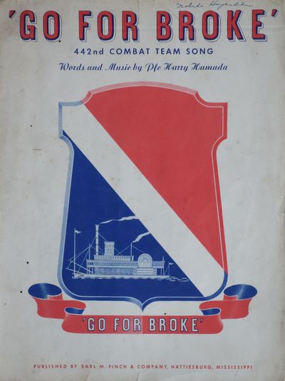
‘Go For Broke’ / 442nd Combat Team Song
[Japanese-Americana - World War Two - 442nd Infantry Regiment] Hamada, Harry Hattiesburg, 1944 Hattiesburg: Earl M. Finch, 1944. Sheet music measuring 12 x 9 inches, 4 pp. Signature of a Nabuko Hayashida on front cover. Slight tears at fold, some toning, two small pinholes, very good overall, quite attractive. Very Good. In Hawaii in May 1942, a battalion of Nisei volunteers was assembled for service in World War Two, despite earlier failures of efforts to recruit Japanese-Americans due to the Army's labeling of Nisei recruits as 4-C enemy aliens. Designated as the 100th Infantry Battalion, they were deployed to North Africa in June 1943, integrating with the 34th Division in active combat. Their subsequent deployment to Italy in September 1943 exposed them to intense warfare, earning them the moniker of the "Purple Heart Battalion" due to their notably high casualty rate. In January 1943, the U.S. War Department officially declared the establishment of the segregated 442nd Regimental Combat Team (RCT), which was comprised of Nisei volunteers originating from Hawaii and the mainland. The culmination of this initiative transpired in June 1944 when the 442nd RCT merged forces with the 100th Infantry Battalion in Europe, subsequently absorbing the latter into its structure. The notable achievements of Nisei soldiers in combat operations prompted the reinstatement of the draft in January 1944, specifically targeting Nisei detainees to augment the ranks of the 442nd. Over time, the 442nd RCT expanded to encompass the 2nd, 3rd, and 100th Battalions; the 522nd Field Artillery Battalion; the 232nd Engineering Company; the 206th Army Band; Anti-Tank Company; Cannon Company; and Service Company. Offered here is a very scarce piece of sheet music entitled "Go For Broke," which was written by the Hawaiian musician Harry Hamada, reflecting the slogan of the 442nd, and performed by Shelby and others during the war as part of efforts to boost morale. Hamada would feature in the 1951 movie "Go For Broke" as Masami alongside several other veterans of the 442nd. This publication of "Go For Broke" is from 1944, seven years before the movie's release. The piece is dedicated to Colonel C.W. Pence. Hamada was a Hawaiian musician who performed with a band called the Shelby Hawaiians or the Shelby Serenaders. They performed as early as 1943. The Hattiesburg, Mississippi merchant Earl M. Finch, who ran an Army and Navy store close to Camp Shelby, befriended Hamada and other members of the 442nd and acted as a sponsor for the group, and eventually published this version despite his business being a dry goods merchant house and not a publishing house. The group, with the support of Finch, performed throughout the country to lift morale. At some point Hamada penned this composition, likely in 1944, as we find no reference to it in 1943 articles, and Finch published it - Hamada's composition would become the theme song of the 442nd, and Hamada would perform at the Halloran General Hospital in New York and the Walter Reed Hospital in Washington, D.C. in 1944, likely performing this composition. Another composition called "Go For Broke" exists as well, and it is unclear to what degree Hamada's work caught on among the regiment. We find two records of Finch's published version of the composition, one listed as part of an online remembrance of the 442nd by the Smithsonian Institution (https://americanhistory.si.edu/explore/stories/day-remembrance-70-years-after-executive-order-9066), which appears to have been on loan from the National Japanese American Historical Society, and another copy held at Stanford, though not listed in OCLC. Finch's story is also interesting, and is the subject of a remembrance on a 100th Battalion History page online (https://www.100thbattalion.org/history/stories/earl-finch/). We find no copies listed in OCLC. Overall a very scarce piece of Japanese-American wartime history.- $2,500
- $2,500
Document Noting the Capture of Patrick Keegan and Patrick O’Brien for the Murder of Colonel Henry F. O’Brien who Was Murdered in the New York Race Riots, and the Payment of a Reward for the Capture, Signed by New York City Mayor George Opdyke and Others
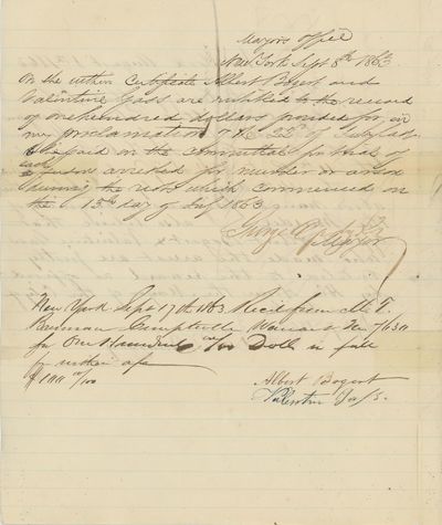
[Irish-Americana - New York Race Riots] [O'Brien, Colonel Henry] Opdyke, George, et al. New York, 1863 New York, 1863. Document measuring 9 ¾ x 8 inches, folded. Signed by George Opdyke and others. Very Good with some splitting at folds else fine. Very Good. In July 1863, the Civil War draft in New York City led to protests, escalating into widespread riots by July 14th. The Irish-born Colonel Henry O'Brien, who had been put in charge of recruiting for the New York 11th Infantry, would die gruesomely in the riots, highlighting the class elements of the unrest which existed alongside the racial elements. Born in Ireland in the 1820s, O'Brien had served with Company H of the 155th New York State Infantry before resigning in February 1863. He returned to New York, promoted to Colonel in June, tasked with recruiting for the 11th New York State Volunteers. The aggressive mandate coincided with high casualty rates for Irish New Yorkers in the Union Army. The Battle of Chancellorsville and Gettysburg increased the challenges, coupled with the perceived injustice of the $300 exemption clause in the Conscription Act. To protest the draft, thousands gathered in Central Park on July 13th, marching across the city. In the 18th Ward, armed protesters gathered on 14th Street. Reports of a threatening mob on Second Avenue and 34th Street prompted police response. O'Brien, offering aid, saw his house attacked, but spared from fire as he didn't own it. Chaos ensued as police faced resistance, and O'Brien led military reinforcements from the 11th NYSV. Attempts to disperse the crowd resulted in violent clashes, with bullets causing casualties, including two children. A fierce battle at the Union Steam Works led to O'Brien's gruesome death at the hands of the rioters, after he had returned to his house likely in a misguided attempt to salvage any belongings. Though multiple assailants caused O'Briens death, no one was ever convicted of the crime, partially due to the mob's intimidation of witnesses and the complicity of his neighbors in the murder. The first people arrested were Patrick Keegan and Patrick O'Brien, after the coroner deemed them responsible. However the charges were later dropped. No one would ever be convicted of the crime. Offered here is the original certification of the arrest of Keegan and O'Brian, signed by multiple officials including George Opdyke, the mayor of New York. The document was first certified by an official with the last name Ramsey, then signed both by the mayor and the officers Albert Bogart and Valentine Gass, who were responsible for the apprehension of Keegan and O'Brian, acknowledging the receipt of the $100 reward. The document is docketed, and crosshatched writing notes from the comptroller's office note the payout to Gass and Valentine. Opdyke's note states that he offered the reward initially on July 22nd. We find no similar documents relating to the riots in the trade, with the closest examples being contemporary manuscript accounts of the riots which turn up occasionally. Overall a remarkable ephemeral survival of the riots and the death of Henry O'Brien. References: Reynolds, Kelly Ann. Henry F. O'Brien, The Man Murdered by the Mob. Glucksman Ireland House, New York University, accessed online at: https://ethnic-village.org/henry-f-obrien-the-colonel-murdered-by-the-mob/, 1/24.- $2,750
- $2,750
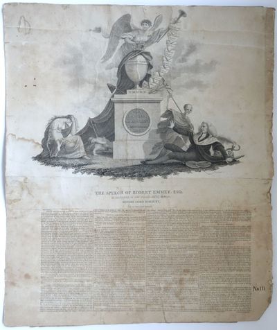
The Speech of Robert Emmet, Esq. As Delivered at the Sessions House, Dublin, Before Lord Norbury, One of the Chief Judges
[Irish-American Imprints - Robert Emmet] Emmet, Robert; Barralet, John James [Artist] Seymour, Samuel [engraver]; Simms, John [Printer] Philadelphia, 1814 Philadelphia, 1814. Composite broadside measuring 20 ½ x 17 inches, consisting of an engraving credited to Barralet and Seymour measuring 17 x 13 inches at upper portion and the text of Emmet's speech, measuring 17 ½ x 7 ½ inches on lower portion. Verso with various reinforcements including with two manuscript receipts dated 1814, which would date the print to around that time, when all three men were in Philadelphia. "No 111" written in margin in ink. Various creases, small tears and some soiling to engraving, good overall and quite presentable. Good. A fabulous mock-up for a broadside created by the artist John James Barralet, the engraver Samuel Seymour, and the printer John Binns in Philadelphia, this being a preliminary version of OCLC 191261216, which would be entitled A correct copy of the speech of Robert Emmet, Esq. delivered at the Sessions House, Dublin, on the 19th September, 1803, before Lord Norbury, one of the chief judges of the Court of King's Bench, and others, before whom he had been convicted of high treason. The design was used for a broadside printed by Menzel and Co. and copyrighted in 1852, as well as a version by the Irish-American publisher William Smith of Philadelphia several decades after the original. OCLC locates two copies but may have the date incorrectly listed as 1803, which despite being the date of Emmet's death was actually four years before Binns moved to Philadelphia, and several years before the receipts on the verso. Overall the broadside represents an early and significant expression of Irish-American anti-English sentiment. "[Binns] was exposed to the advanced ideas of the Irish patriots and Volunteers, making him a republican. Between 1792 and 1794 he played a small role in the Dublin Society of United Irishmen, which was seeking parliamentary reform and Catholic emancipation. In 1794 he moved to London, where he worked first in the plumbing trade, then lived off the fees from hiring out debating rooms that he rented in the Strand. He joined the radical London Corresponding Society and was soon prominent on its executive committee. In 1796 Binns traveled the provinces as an LCS delegate hoping to revive the movement for political reform. In Birmingham he was arrested for uttering seditious words in a public house. After long delays he was acquitted in 1797, probably because a sympathetic court official rigged the jury. Soon thereafter, Binns left the LCS, but almost certainly joined the underground revolutionary United Irishmen in London (his comments on this part of his life in his autobiography are disingenuous). He was arrested twice more, the most important occasion, in February 1798, leading to a charge of high treason. Again he was acquitted, although one of his associates, the Catholic priest James O'Coigley, was hanged. In March 1799 he was jailed under the Suspension of Habeas Corpus Act and released after nearly two years." -ANB Barralet and Seymour's involvement were also significant. Barralet had emigrated from Ireland several decades earlier. Seymour would later gain fame for his illustrations of westward Euro-American travels among indigenous Americans, and being a native-born Englishman his involvement in this project is notable. Overall a very scarce early Irish-American broadside, this being the third known copy and the only which exists in draft form.- $7,500
- $7,500
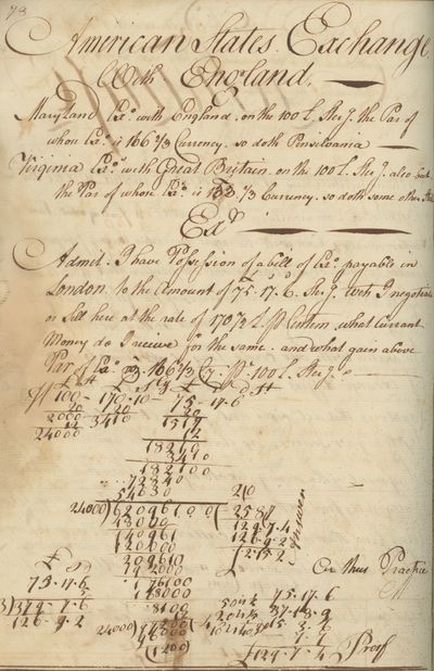
18th-century American Schoolboy’s Computation Notebook, Kept by Joseph Brewer of Maryland, Using Aspects of Trade and Diplomacy as the Basis for Mathematic Exercises
[History of Science and Mathematics - Children's History] Brewer, Joseph Maryland, 1787 Maryland, 1787. One Volume. "Arithmetic Book." Brewer, Joseph (Newton). [Maryland]: June 17, 1786 - (April 21,1789, or after). Folio, half calf bdg, contemporary or old boards; scuffed and chipped and bumped, later rebacking. 80 folio sheets (of which 15 blank) with seated Brittania watermarks. 135 pages mss text in brown ink, original manuscript pagination recto-verso, sgd and dated on front pastedown; internally toned, some closed tears. Near Fine. This manuscript journal comprises an 18th-century American student's mathematics course from 1786 - 1789. The author, Joseph Brewer, signs and dates the journal on the front pastedown, but he never mentions his hometown or his parentage. It is only in the last exercises of 1789 that he reveals himself more fully as "Joseph Newton Brewer," and further, firmer internal evidence regarding this identity is wanting. However, inasmuch as he was ostensibly a student in his mid-teens at the time of composition, and makes frequent reference to Maryland in numerous exercises in his book, it is likely that he was Joseph Nathaniel Newton Brewer (January 10, 1771 - January 8, 1841) of Edgewater, Anne Arundel, MD. Marriage and birth certificates found among online genealogical corpora do corroborate this. Joseph Brewer's "Arithmetic Book" is noteworthy among other extant 18th-century curricular manuscripts, because it showcases a variety of word problems, all of which relate explicitly to period themes. There are expected school subjects such as fractions and decimals, and practice tables, but most of Brewer's assignments are more practical in scope. They treat topics of an especially economic, even mercantile, nature, including problems of currency conversion; partnership, exchange, and barter; loss and gain; legacies and wills; land and surveying. The commodities Brewer emphasizes his math exercises are also of interest, as they emphasize in most instances prestige goods and other expensive imports e.g. beer, rum, chocolate, gold dust, coffee, and tobacco. He writes, in one example, "Three merchants A. B. & C. freight a ship with 248 tons of wine," before extreme weather causes them to throw much of it overboard, necessitating calculations. In another, three men spend a guinea at a tavern, each consuming varied amounts. The persons described in the word problems are also worthy of further study, as in one case where various farm personnel are featured: "one man, three women, and one boy made a crop of 1700 pounds of tobacco...." (p14). Brewer's journal also contains several practice exercises in letter-writing, as to foreign traders (p93). The author of the "Arithmetic Book" seems to have enjoyed this work, and there are many whimsical flourishes in his handwriting (and a few occasional doodles). Most surprising however, is Brewer's decision to conclude his journal with a composite psalmic coda: "Oh God, who didst command the light to shine out of darkness / speak but the word and light shall dart into my soul at once / when thou my lips, and my mouth shall show forth my / praise shall burst out into a chearful [sic] song" Overall an interesting relic of education during the years following the Revolution, which should be of interest to scholars of early American education due to its detail and thematic content.- $1,375
- $1,375
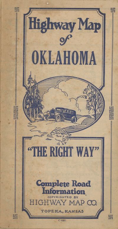
Highway Map of Oklahoma. “The Right Way.” Complete Road Information
[Great Depression - Automobile Travel - Oklahoma] Author Unknown Topeka, 1930 Topeka, 1930. Folded map measuring 28 x 17 inches. Some small tears at folds, very good. Very Good. A scarce depression-era map of Oklahoma, with graphic advertisements to the verso showing the range of automobile-centric establishments in the state at the time. The map shows all the automobile routes of the time, with text along the borders listing the towns and the telephone numbers of various services and lodging options. The instructions on the the top read "Put Out Your Fires / Leave a Clean Camp / Keep the Streams Pure / Don't Be a Road Hog." According to the single copy in OCLC, at the Denver Public Library, the map was printed in 1930, though we see no date on the map itself. The depression hit Oklahoma following the drought in 1930, which also coincided with the opening of the East Texas oil field. This map is a relic of the period just before the state's economic downturn, with the early automobile infrastructure still intact and vibrant.- $450
- $450
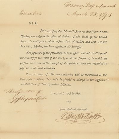
Circular / Treasury Department, March 25, 1795. Sir, It is necessary that I inform you that John Kean, Esquire, has resigned the office of Cashier of the Bank of the United States, in consequence of an Infirm state of health, and that George Simpson, Esquire, as been appointed his Successor. [Signed by Wolcott and Simpson]
[Finance - Early Republic] Simpson, George; Wolcott, Oliver; United States Treasury Department Bath, Massachusetts, 1795 Bath, Massachusetts, 1795. Folded circular, franked by Wolcott and addressed to William Webb, Esquire of Bath, Massachusetts [now Maine]. With the signature of George Simpson. Fine condition. Fine. An uncommon treasury circular announcing the appointment of George Simpson as cashier, following the retirement of John Kean due to illness. Simpson would serve as cashier from his appointment in March of 1795 until the Bank's decommission in 1811. Simpson would take up residence across the street from the bank on Chestnut Street, and was hired by Stephen Girard as cashier of the Girard Bank, which operated out of the same building, in 1811. He would serve in this position until his death in November of 1822, after which Girard promoted Simpson's first teller, Joseph Roberts, to be Cashier. We find no other examples of Simpson's signature in the trade, though several letters to him have surfaced over the years. Despite his low profile from a policy standpoint he was a key figure in the Bank of the United States. We find no record of this circular institutionally, though it is listed in Bristol and Shipton and Mooney. Wettereau, James O. "The Oldest Bank Building in the United States." Transactions of the American Philosophical Society 43, no. 1 (1953): 70-79. https://doi.org/10.2307/1005663. Wettereau, James O. "New Light on the First Bank of the United States." The Pennsylvania Magazine of History and Biography 61, no. 3 (1937): 263-85. http://www.jstor.org/stable/20087054. Bristol B9395. Shipton & Mooney 47660.- $1,500
- $1,500
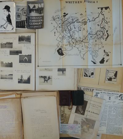
Collection of Maps, Diaries, Manuscripts and Photographs Documenting the Life and Work of the Con Artist, War Correspondent and Cartographer Jack or Jacques de Beaufort aka “The Dude Reporter,” with a Focus on His Cartographic and Literary Activities in Mid-Century Los Angeles
[Con Artists - Cartography - War Correspondence - California] De Beaufort, Jack or Jacques Europe and California, 1950 Europe and California, 1950. Includes two small diaries from 1901 and 1917 with sporadic entries, a large photo album measuring 14 x 11 with appx. 400 small photographs from 1906-1909 attached to album pages, most measuring 3 x 2,, as well as a few larger format images laid in. With 100 plus pages of typed pages including retained correspondence, story ideas, and various other manuscripts. With eleven maps, produced for his "Of Men and Maps" series, including five copies of a large map entitled "Whither Russia," in varied states and in large sizes up to 30 by 36 inches, and a handful of small ephemeral pieces. Generally near fine condition, with the exception of the album, which is missing its rear board and has some pages loose and torn. Very Good. J.M. de Beaufort, a war correspondent for the London Daily Telegraph and New York American during World War I, recounted his wartime adventures in the 1917 book "Behind the German Veil: A Record of a Journalistic War Pilgrimage." Originally arriving in Chicago in 1909, he married a steel magnate's daughter and pursued a career in show business. However, by 1912, he had gone through a divorce and transitioned to newspaper work, earning the moniker of the "Dude Reporter." Originally born in the Netherlands as Jacques Albert Uilenbroek, he was thought to be a deserter. He spent the latter part of his life in the United States, apparently jailed in San Francisco for a stint in the 1920s, and eventually settled in Los Angeles. Offered here is an interesting smattering of material from the life of the mysterious De Beaufort, which bookends his most unusual career and life with a large visual photographic record of his life in Europe as a young man and over a hundred pages of manuscript material from late in his life, with a highlight being several maps in draft form for an apparently unpublished project called "Of Men and Maps." As a group the material shows the work of an ex-con artist and war correspondent trying to regain his form while living in Los Angeles. He was still writing as a "Special Correspondent" at this point, though the title seems to have been fully honorary. Also included are two small pocket journals, with sporadic notations from his life in Europe in 1900 and in 1917. In its entirety the group gives an interesting visual and manuscript record of a literary, fraudulent and imaginative transatlantic life and intellect. The cartographic highlight of the group is several iterations of a large map called "Whither Russia," in varied forms, which show an interesting interpretation of the sphere of influence of the USSR and its growth from 1939 to 1946. Also included are two drafts of a map of Operation Market-Garden in the Netherlands in 1944, an unidentifed tactical map of a military battlefield, a map called "Middle East Jackpot," showing the division of territory between the Allied and Axis powers, a map called "Dawn's Early Light, some reproduced small format maps from the De Beaufort's and a small map called "Gifts from Yalta." De Beaufort was working on these maps for a column called "Of Men, Maps and Memories," that was published in the East Los Angeles Tribune. He also sent the columns out in newsletter form from his address at 1635 N. Ogden Drive in Los Angeles. The collection of manuscripts, drafts and retained correspondence tackle a range of subjects, perhaps most interestingly those detailing De Beaufort's creative process - drafts of stories, lists of ideas for stories, and letters. His over the top style is on display in a lot of the writings, some of which are of unknown origin and purpose. The documents contain correspondence between De Beaufort and Edwin Pauley, the oil man and presidential advisor. In one untitled essay, he asks himself the question "What has been your most thrilling experience?" and his reply is, " Silly questions. Who or at least what newspaperman of some 25 turbulent years standing - and falling - could answer such a question. A reporter's life has a thousand thrills. There was that rainy day in Marcy 1915, in the fortress of Loetzen, when I stood face to face with Hindenburg. Hm, yes, that was quite a thrill..." De Beaufort was entrenched in the Los Angeles journalistic scene at this point, and the documents show the degree to which he relied on his former glories to attempt various career revitalizations endeavors. The album of photographs from 1906-1909, over 400 in total, give a visual record of the young Uilenbroek's life in Europe. The star of the collection is his bulldog Bob, who travels throughout Europe with him and eventually comes to America by 1907. Mary, who we presume to be his future wife, is featured heavily in the images. It is unclear whether he was working at this point, the images show affluent young people (and their dog) in varied cities and are purely of a personal nature. Other photographs laid in are relics from his war correspondent period. The loose photographs and ephemera are a mix of portraits from different periods from his life, including two pictures of Sydney Turing Barlow Lawson, one signed by his widow. The journals are sporadically filled and hard to decipher though one legible passage says "drinking all day." Overall the group gives evidence of this intriguing life and is the only extant group of material relating to Beaufort, to our knowledge, with the exception of a single journal from his time in Belgium during WWI that was sold at Bonhams and is still available in the trade as of this writing.- $3,250
- $3,250
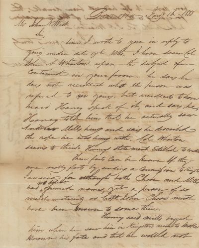
Letter to John K. West, Member of the Notorious New Orleans Attorney, Discussing a Conversation with John Austin Wharton Concerning a Crime in Texas, a Hanging, and Fugitives in Jamaica, 1838
[Crime - Texas - New Orleans] Andrews, Edmund Republic of Texas, 1838 Republic of Texas, 1838. Stampless letter, folded, with red two-line handstamp of Steam Packet Columbia on January 16, 1838 from Brazoria Tex. to New Orleans. Fine condition. Fine. An intriguing letter written by Edmund Andrews, a judge in Brazoria, Texas, who had arrived in Stephen Austin's colony eight years before he penned this, in 1830. The letter is written to John K. West, the New Orleans attorney who was an original member of the notorious "New Orleans Associates." Andrews discusses a conversation he had on behalf of West with John Austin Wharton, who would die later in 1838, relating that Andrews had a conversation with Wharton on West's behalf. The conversation with Wharton revolved around a man with the last name Chase and Andrew Mills, who had both left Texas, presumably, and traveled to Kingston, Jamaica, where Mills was hanged for an undisclosed crime. Andrews writes that Wharton related that that Mills told him he "would not have done it if he had not been drunk," presumably talking about the crime for which he was hanged. Overall a very intriguing letter relating to crime, exile and misdeeds in the Republic of Texas, which should be of interest to scholars of the Republic. Full text follows: Brazoria, Jan'y 16, 1838 Mr. John K. West Sir, Since I wrote to you in reply to yours under date 19th ulto., I have seen Col. John A. Wharton upon the subject contained in your favor. He says he does not recollect who the person was referred to in yours, but recollects to have heard Haney speak of it, and says, he, Haney told him that he actually saw Andrew Mills hung and says he described the rope he was hung with. Col. Wharton seems to think Haney's statement entitled to credit. These facts can be known, if they are really facts, by sending a commission to Kingston, Jamaica, for although both Chase and Mills had no doubt assumed names, yet a person of so much notoriety as Capt. John Chase must have been known to some there. Haney said Mills begged him when he saw him in Kingston never to make known his fate and that he would not have done it if [he] had not been drunk. The foregoing is the substance of the conversation held with Col. J. A. Wharton. I am yours truly, Edmund Andrews.- $1,250
- $1,250
Collection of Seventy-Six Checks Written to Chinese Businesses in Montana, 1870-1872
[Chinese-American Communities - Montana - 1870s] L.H. Hershfield & Brother Bank Montana Territory, 1872 Montana Territory, 1872. Lot of seventy-six checks measuring 8 ½ x 4 inches, with vignette illustration of a prospector and his dog. With one additional document relating to the Hershfield account with the Bank of California. Most checks issued to "Gold Coin," and drawn on the Bank of California in San Francisco. The checks are printed by Robert F. Macey Stationery in New York. Fine condition with an occasional tear and chip. Fine. In 1870, one out of ten residents of Montana Territory were of Chinese descent, a figure that would decline precipitously in the ensuing decades until Chinese-Americans made up less than one percent of the population around the turn of the century. Chinese immigrants arrived in Montana following the discovery of gold in Bannack and Virginia City in the 1860s. Many of the Chinese immigrants settled and worked in the Big Belt Mountains east of Helena, including the Cave, Cooper, Oregon, and Confederate Gulches. Collected here are a collection of seventy six checks from Helena in 1870 and 1871 written to Chinese-owned businesses and cashed at the L.H. Hershfield and Brother bank in Helena, and drawn on the Bank of California in San Francisco. The checks contain the names of over thirty different Chinese merchants operating in Montana at the time - with some companies like Wan Yuen and Co. having multiple checks present. As a group they offer an interesting map of the Chinese-American business community operating at the time, and the duplicate checks, which sometimes have notes on the verso, giving a representation of the relative size of the firms and individuals involved. The LH Hershfield & Bro. Banking House in Helena operated from 1865 to 1882, in Last Chance Gulch, near the corner of Bridge and Warren Streets. It later became the Merchants National Bank, from 1882-1898, then the Union Bank and Trust Company from 1898 to 1859. Hershfield also had a banking operation in Virginia City during the Gold Rush period. Overall the group documents the Chinese-American community during the period and the breadth of economic activities of Chinese-Americans in Montana's early mining camps.- $4,500
- $4,500
Lighte & Bradburys’ Patent Insulated Full Iron Frame New Scale Piano Fortes! Also, Piano Fortes from John B. Dunham. Sheet Music and Music Books Sold at New York Prices. Martin’s Guitars
[California - Music - Ephemera] Salvator Rosa's [Martin Guitars] San Francisco, 1864 San Francisco, 1864. Broadside measuring 12 x 8.5. Some wear and archival tape repair to margin, fine contrast, excellent condition overall. Very Good. An interesting broadside advertising the Lighte and Bradbuiry piano as well as Martin Guitars, printed for the Salvator Rosa music store at 615 Montgomery Street in San Francisco. Lighte and Bradbury was in its third iteration in the period from 1858-1864 when this broadside was printed, having been started by the German immigrant Ferdinand C. Leuchte in 1847, who did business with a range of partners after anglicizing his name to Lighte. Among the testimonials listed on the broadside is praise from Lowell Mason, the composer and music director. Salvator Rosa's store was around from at least 1852, when a fire in the city destroyed the building on Clay St., making this location at 615 Montgomery Street at least the second for the firm. The firm published sheet music including "Fireman's March" and "Garibaldi's Hymn." Martin Guitars had been based in Nazareth, Pennsylvania, since 1838 and were a relatively small company at this point before the growth of popularity of guitars and the shift to steel strings that happened in the early twentieth century. We find no other nineteenth century examples of broadside advertisements for Martin in trade records.- $1,500
- $1,500
Articulos Filosoficos y Cartas a un Campesino
[California - Mexican-American Imprints - Los Angeles] Verea, Ramon Los Angeles, 1909 Los Angeles: La Aurora Mexicana, 1909. 8vo, wraps, 92 pp. Some chips to front wrap and first two pages, slight brittleness, very good minus overall. Very Good. Ramon Verea was a writer and inventor who was best known for his invention of a mechanical calculator capable of multiplying large numbers with great speed, an invention he never marketed but that has remained legendary in history of computing circles, with a prototype held at the IBM corporate headquarters. He was also an editor and writer, founding the magazine El Progreso in 1884. Known for his anti-colonial ideas, he moved to Guatemala in 1895 and then to Buenos Aires in 1897, dying two years later. This collection of Varea's collected essays on various subjects was published by the "La Aurora" Libreria Mexicana, located at 611 North Spring St. in Los Angeles, a publishing house about which we find no information, though it is notable as a Spanish-language publisher of radical works. OCLC locates six copies.- $450
- $450
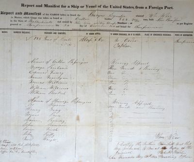
Shipping Manifest for the Barque Equator, Documenting Cargo on a Voyage Around Cape Horn, 1850-1851
[California - Gold Rush Period - Mercantile History] Alsop and Company Callao, 1850 Callao: Alsop and Company, 1850. Folded ship manifest measuring 15 ¼ x 12 ½ inches. Fine condition with slight normal wear. A very scarce Gold Rush period shipping manifest for the Barque Equator, captained by William Weir, listing the passengers and cargo for a voyage to San Francisco in December of 1850, with notations showing the vessel's arrival in San Francisco in May of 1851. Alsop & Co. was the work of Joseph Alsop, the grandson of Continental Congress delegate John Alsop, and his friend Henry Chauncey. Originally from Middletown, Connecticut, the pair established Alsop & Co. in New York City in 1824, and would eventually play a large role in the gold trade in California and trade extensively in South and Central America. Chauncey, Alsop and others were among the partners in the trans-Panamanian railway that helped transform trans-continental trade in 1850. One of Alsop & Co.'s treasure boxes was aboard the S.S. Central America when it sank in 1857, carrying gold to the Eastern United States from Panama. The shipping manifest offered here lists the primary cargo as 195 tons of coal, and also lists the names of fourteen passengers on the voyage. Imported coal - from Callao in this case - was essential to heat houses and run furnaces at factories, including assay offices, before the development of a local coal industry in California. We find only two instances of Gold Rush-era ship manifests - which were usually thrown away - surfacing in the trade or auction records, this one and one other, which sold for $3,600 at PBA Galleries in 2014.- $3,000
- $3,000
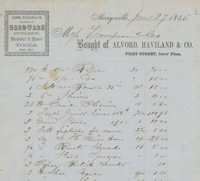
A Group of Documents, Printed and Manuscript, Relating to Marysville in the 1850s, Including Several Original Land Claims
[California - Gold Rush Period - Marysville] Marysville, California Marysville, 1860 Marysville, 1860. Marysville, 1850s-1860s, the bulk mid-1850s. A collection of documents including eleven receipts, three manuscript legal documents, four manuscript documents relating to land claims; five partially printed documents relating to land claims; two letters from the US Land Office in Marysville, 1858, regarding land claims; six billheads from Marysville firms with receipts for a range of goods, some illustrated; one letter from Marysville, written in 1853, concerning a death in a family. Generally fine condition. Fine. A mini-archive or assemblage of documents relating to the early Euro-American citizens of Marysville and its environs in the 1850s. The population of Marysville grew quickly after the town's incorporation to 10,000 by the mid-1850s due to its strategic location close to the gold fields, but the levee system put in place to control flood damage limited the town's growth beyond this initial phase. The documents here relate to Marysville in this early period of growth, and include several quitclaim land deeds as well as illustrated billheads. As a group they offer an ephemeral record of the city in its early period with the legal documents and deeds showing the means with which the area was settled. A well preserved group overall.- $1,250
- $1,250
Instructions No. 10, 1850. By Command of the Postmaster General. Notice to the Public, and Instructions to all Postmasters, Sub-Postmasters and Letter Receivers. California and Oregon, Option of Transmitting Correspondence, for Through United States
[British Postal History - California and Oregon - Gold Rush Period - Panama Route] Royal Mail Great Britain, 1850 Great Britain, 1850. Broadside measuring 9 ⅞ x 15 ⅜ inches. Some chipping and wear to edge, ink number written in corner, two small section of loss due to improper mounting, very good overall. Coat of arms of the United Kingdom above printed text. Very Good. A scarce broadside relating to British postal rates across the Panama Route through the Chagres River, which supplied mail to California and Oregon beginning in 1848 before eventually being replaced by the Overland route in 1860. The service was characterized by long delay times, as steamships on either side of the isthmus were often not coordinated, causing major delays in the delivery. Several different steamship companies operated privately, some carrying express mail. The letters were transported by canoe or pack animal across the isthmus. Postmaster General Cave Johnson began establishing post offices in California in 1848. Johnson also oversaw the transition to the prepaid delivery system. The broadside here, of which we find no other records, does state that postage must be prepaid, and that the route can be accessed by writing "via New York" on the letters. A scarce postal history item relating to the expansion of mail services to California. We find no other records of this institutionally or in the trade.- $1,500
- $1,500
Laminated Tintype Portrait of an African-American Man with the Prince Hall Freemasons Insignia, c. 1910s
[African-Americana - Prince Hall Freemasonry - Photography] American, 1910 American, 1910. Tintype measuring 8 x 6 inches with an African-American portrait, laminated at borders with a decorative frame with the insignia of the Prince Hall Masons. Some chips to lamination at corners, very good. Very Good. An interesting portrait of an African-American man with a decorative masonic border bearing the distinctive shape of the Prince Hall Masons emblem. Prince Hall Freemasonry stands as the earliest officially recognized and consistently operational organization established by individuals of African descent. Its inception occurred on March 6, 1775, when Prince Hall (ca. 1748-1807), a proponent of abolition and a civil rights activist, alongside fourteen other free black individuals, underwent initiation into freemasonry. They established African Lodge No. 1 on July 3, 1775. In 1784, a formal request for a charter was submitted to the Grand Lodge of England, and upon approval, African Lodge No. 1 was redesignated as African Lodge No. 459 in Boston, Massachusetts. By the time this picture was taken, there were numerous lodges, making the exact location or identity of the sitter unknown.- $375
- $375
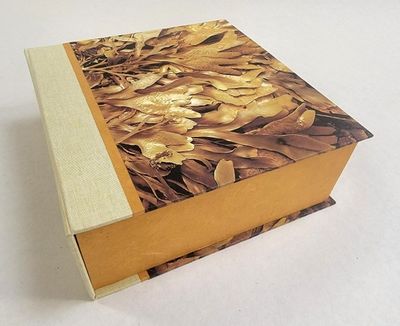
Copepodilia Collectanea.
Wight, Gail . San Francisco, California:, 2022. San Francisco, California:: Salt Point Press,, 2022.. Edition of 20. 5.5 x 7" closed, extends to 10 meter (64"); 80 pages. Accordion structure. Letterpress printed in Cochin. With illustrated paper wrapper. Archival pigment prints are on Canson Infinity Aquarelle. Letterpress pages at the beginning and end of the book are printed on Rives BFK with mulberry hinges. Housed in 8 x 8.25 x 3.25" clamshell box constructed of archival book board covered with pigment prints on Moenkopi kozo. Signed and numbered by the artist. Each box contains a unique piece of seaweed from the Pacific coastline in northern California. Salt Point Press: "'Copepodilia Collectanea' presents an imaginary menagerie of copepods - minuscule aquatic crustaceans - created using seaweed pressings. High resolution pigment prints of the pressings retain the textures and dimensionality of the original pressings. "Text by Melanie Stiassny, ichthyologist at the American Museum of Natural History, introduces the fundamentals of copepod life." Gail Wight: "While reading Melanie Stiassny's gorgeous book Opulent Oceans, I came to the chapter titled ' The Golden age of Copepodology' and my mind was set ablaze. … With just a few facts in hand - they have little swimmy appendages for movement, sometimes egg sacs, and often tiny antennae - I decided to draw my own imaginary menagerie of copepods, using seaweed as my medium.- $1,800
- $1,800

Vincent HADDELSEY : La Corrida, Lithographie originale signée
Art, Affiches et Gravure Vincent HADDELSEY (1934-). - La corrida, 1974. - Lithographie originale. - Signée au crayon. - Numérotée sur 100 exemplaires (numéro de la photographie donné à titre d'exemple). - Sur Vélin, 53x 38 cm . - En excellent état . -- $111
- Artfever |
- $111

Vincent HADDELSEY : Jeune fille sur sa calèche, Lithographie originale signée
Art, Affiches et Gravure Vincent HADDELSEY (1934-). - Jeune fille sur sa calèche, 1974. - Lithographie originale. - Signée au crayon. - Numérotée sur 100 exemplaires (numéro de la photographie donné à titre d'exemple). - Sur Vélin, 53x 38 cm . - En excellent état . -- $111
- Artfever |
- $111
Salvador Dali : Les cavaliers bleus, Gravure originale signée
Art, Affiches et Gravure Salvador DALI (1904 - 1989). - Les cavaliers bleus, 1973. - Gravure originale à l'eau-forte en couleurs. - Signée dans la planche. - Sur papier Japon 28 x 38 cm. - REFERENCES : . - - Catalogue raisonné Field #73-1 J. - - Catalogue raisonné Michler et Lopsinger #516. - Excellent état- $324
- Artfever |
- $324


Arnulf RAINER : Paris, Louvre en orange, Gravure originale
Art, Affiches et Gravure Arnulf RAINER (1929-). - Paris, Louvre en orange. - Gravure originale à l'eau-forte et au burin. - Non signée. - Sur vélin 41 x 50.5 cm. - Authentifiée par le cachet sec de l'éditeur Chalcographie du Louvre. - Excellent état- $335
- Artfever |
- $335
Rahman, Abdul (illustrator). “Remember the African Holocaust”/Lynchings. [Caption Title]
New York, 1992 New York: High Awareness, Inc, 1992. Very good. Poster measuring 23¾" x 18". Very good with scattered light creases. This is a large calendar meant to bring awareness of the history of slavery, as well as lynchings in the United States. The days of the calendar are in columns at opposite edges of the poster, with three large illustrations in the middle. The illustrations depict the process of enslaving Africans, with visceral drawings of the capturing of new slaves, the middle passage, and breaking camp. Interestingly, in the breaking camp image, a young man is being whipped and the aggressor is also Black. At the bottom of the poster are two columns of text which detail the lynchings which are highlighted in red on the calendar. In between those columns is text dedicating the poster to Ida B. Wells whose early investigative journalism led to the topic of lynchings becoming part of the national conversation. A searing reminder of slavery and lynching. OCLC locates no copies.- $600
- $600
![Carver Federal Savings and Loan Association Presents a 1967 Calendar of 12 Great Days in the Growth of Carver Federal Savings. [Cover title]](https://rarebookinsider.com/wp-content/uploads/2024/04/1582121077.0.l.jpg)
Carver Federal Savings and Loan Association Presents a 1967 Calendar of 12 Great Days in the Growth of Carver Federal Savings. [Cover title]
New York, 1966 New York: Carver Federal Savings and Loan Association, 1966. As new. 5½" x 8 3/8". Stapled wrappers. pp. [32]. As new in original illustrated, unused mailing envelope which is good due to the lack of a flap and some loss to the front panel. The 1967 edition of the CFSLA calendar is quite different from the others: it's essentially a short illustrated history of the bank itself, beginning with the initial meeting of Harlem residents who sought to create a community-owned banking institution for African Americans. Other months cover the bank's opening day, its expansion to other offices, its first church account and its first computer. The illustrator is unidentified.- $400
- $400
26 Sketches in Color
Barr-Sharrar, Beryl & Pierre Lecuire A remarkable sketchbook with 25 original gouache paintings (there is no work number 14) by Beryl Barr-Sharrar, for Pierre Lecuire. Small oblong octavo (8 1/8 x 5 1/4 inches). Cardboard covers, metal spiral binding. Some light bumping to edges, paintings in beautiful and bright condition, overall excellent. N.p. (Paris), 1968. This beautiful notebook is inscribed inside the front cover, "Pour Pierre de Beryl, 20 Août, 1968, ces 25 esquisses en couleurs". The title is hand-written on the front cover, and a date of 1965 given under Barr-Sharrar's name. There is also a hand-written note from Lecuire, which mentions that Béryl was his neighbor in Paris in the 1960's and was married first to sculptor Roger Barr and then to Bill Rubin of the Museum of Modern Art, and has since returned to New York. Beryl Barr-Sharrar (b. 1935) is an American artist who studied the American Abstract Expressionists in Berkeley and New York before moving to Paris in the 1960's and beginning her career as a professional artist. In 1962 she co-founded the College Art Study Abroad program, and served as its director until she returned to the United States in 1968. She taught painting and printmaking at Mount Holyoke, and in 1970 began studying classical archaeology at the IFA at New York University. She continued to paint and exhibit her work for several years but after 1980, focused primarily on her academic career. A handful of years ago, she returned to exhibiting her work as a painter with a three-person show in Long Island City, in 2016. Her work was exhibited at the Lucian Durand Gallery in 1967, and of her paintings it was said, "Beryl Barr-Sharrar's work has the vigor and know-how of American action painting at its best, and the refinement of color of the School of Paris. The result is both captivating and awe-inspiring." Pierre Lecuire (1922-2013) was a French poet and publisher who collaborated closely with numerous artists to design and publish beautifully crafted books. It is unclear how exactly Lecuire and Barr-Sharrar crossed paths, but perhaps he became aware of her work during those exhibitions in Paris in the late 1960s. The 25 small paintings in this sketchbook showcase Barr-Sharrar's study of Abstract Expressionism and her bold use of color. A beautiful and unique volume of original art.- $2,750
- $2,750