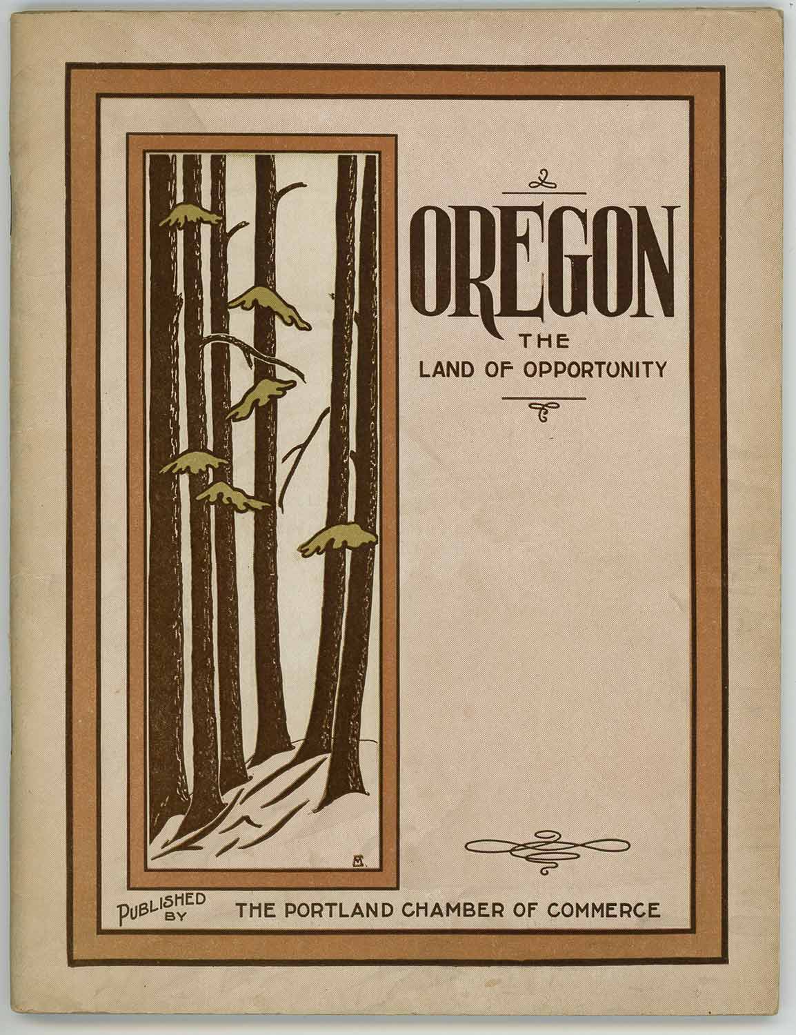
OREGON - PORTLAND)
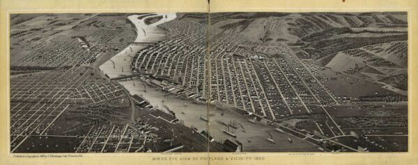
Accordion fold viewbook, 17 single-page illustrations and 1 double-page illustration in black and white, 5 x 6 inches, decorative debossed paper-covered boards with cloth spine. Covers worn and faded; splits to head and tail of outer spine repaired with tape at tail; many fold lines have short splits at the tail; the double page birds eye view illustration of the city has been repaired on the verso and is now detached from the following sheets of single page illustrations which are in overall very good condition on slightly glossy paper. The views are street scenes or montages of city buildings and natural scenery. Many buildings have since been demolished, including the Hotel Portland, the Marquam opera house, and Oregon Pottery works. A birds eye view shows a sparsely populated city with fields and trees where neighborhoods now exist. Five OCLC listings: California Historical Society, UC Berkeley, Multnomah County Library, University of Oregon, and Seattle Public Library.

OREGON - IMMIGRATION) Hyskell, C.M.
BOOKLET, folding color map inside back cover, full page and in-text black and white illustrations, 7 x 5 1/2 inches, lxii pages, color pictorial wrappers with staple binding (softbound). Light soiling to covers, interior in very good condition, map in near fine condition. Includes information about fruit growing and other types of farming, industry etc. Fascinating information about relative wages for labor historians -- bakers worked an average 10 hour day for $3.50, glassmakers for $3.25, railroad section men for $1.50. Many professions are divided into male and female wages, in each of these, the female earns about one-half to two-thirds as much as her male counterpart.
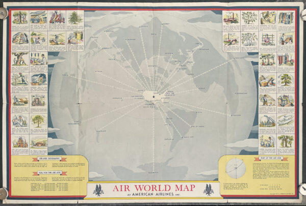
WORLD AVIATION MAP - WORLD WAR II - AMERICAN AIRLINES)
Color poster, pictorial map, image 22 x 33 inches (56 x 84 cm) on sheet 23 x 34 inches, folding to 11 1/2 x 8 1/2 inches as issued. Soft general creasing, multiple splits to fold ends up to 3/4 inch, short splits at fold intersections (3/4 inch at left centre fold), good condition overall. This simple but graphically striking map is a fine example of the "air age" geography that was a hallmark of the late 1930s and 1940s in America. Mapmakers such as Richard Edes Harrison and Charles Owens employed new map projections to convey a more realistic sense of distance than the traditional Mercator projection allowed. In this map issued by American Airlines with the United States at its centre routes are represented by lines of airplanes: "The airplanes on the map are spaced 250 miles apart, each one representing one hour's flight. By counting the number of airplanes along any route, you can find the number of hours it takes to reach the places shown from the United States by air." The map is bordered by illustrations of products used in building airplanes: "some of the vital Air-Age materials are listed here.to understand the needs of our country in the Air age, we must know what materials are needed to build airplanes, where they can be obtained, how they may be shipped, and how accessible are the sources of supply." Under the heading "Fuel for the Air Age" is a listing of six plane types with speeds and number of miles per gallon flown, so that, at 10 cents per gallon, "you can easily figure.how many War Stamps would be needed to pay for the fuel to fly a warplane to any point on the Air World Map."
VICTORIAN EASTER CARDS)
Hardbound scrapbook, unpaginated (46 pages), 15 x 12 3/4 inches, containing approximately 90 holiday cards, trade cards, and illustrations of various sizes, mostly chromolithographic. Paper covered boards, heavy gilded decorative pictorial embossed covers. Rubbing to cover spine and extremities, chipping to lower left corner of back cover, age toning to sheets, multiple tears, light wear and abrasions to some images; cards in good condition overall, bright and attractive. The theme that emerges is one of springtime, Easter, innocence, and Christianity. Cards depict Bible scenes, fruit, women and children, chicks, eggs, kittens, flowers, and doves; some magazine illustrations are also pasted in. The large size of the scrapbook allows for some unusually large items to be included. Most images are undated but some have the dates 1887, 1896, and 1898, and a calendar toward the end is for the year 1901. The scrapbook itself has a patent date of March 1876.
ROCKWELL, NORMAN) Rockwell, Norman (illus).
Four offset color lithographs, image area 13 3/4 x 10 3/4 inches on sheet 16 1/4 x 12 1/4 inches, WITH ORIGINAL MAILING ENVELOPE. Envelope: moderate wear and soiling with two 1 inch areas of paper loss, penciled name to verso. Prints: light edge toning, soft general creasing, slight bump to upper corners, tiny chip to lower right corner of Freedom to Worship print (well outside image area), 1/4 x 1/2 inch paper loss to left margin of Freedom from Want print (outside image area); overall good clean condition. The complete set of Norman Rockwell's most famous illustrations: Freedom of Speech, Freedom from Want, Freedom from Fear, and Freedom of Worship. Rockwell intended them for patriotic posters, but the Office of War Information wasn't interested. They were subsequently published by the Saturday Evening Post, and were so popular that in May 1943 the Post and the U.S. Treasury Department started a joint fundraising campaign by sending the original paintings on an exhibition tour. These prints appear to be souvenir of that tour -- an eagle printed at upper left on the enveope carried a sign reading "U.S. Treasury Department and Saturday Evening Post WAR BOND SHOW".
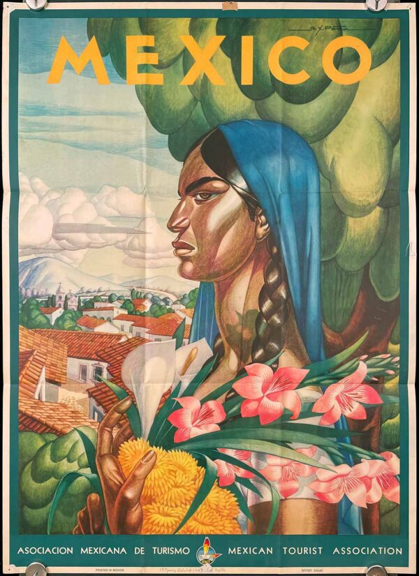
MEXICO TRAVEL POSTER) Peña, A.X. (illus).
Vintage color poster, 36 1/4 x 26 1/4 inches, folding as issued to 12 x 8 3/4 inches. Pinholes, abrasions and/or short tears at margin corners and centers, slightly entering image border; paper residue to center upper margin; penciled address to center lower margin; green stain on verso shows up as green shadow on woman's neck (see detail image); otherwise very good bright condition; colorful image would display well. An attractive image of a woman standing proudly with an armful of flowers in front of a village. The artist, whose signature appears at upper right, was the Mexican painter Alfonso X. Peña (1903-1964). A photo of the original painting appeared in a 1936 El Nacional article in which the author wrote that Peña's "work is characterized by color that preserves all the lights and all the vibrations of the people and things that can be found in regions of the Republic, that is Tehuantepec, the mesa, the coast.?
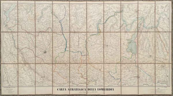
ITALY - LOMBARDY ca. 1855 MAP) Doyen, Flli. (lithographed by).
Map, lithograph with handcolor, divided into 30 panels on linen backing, 21 x 42 inches on sheet 23 3/4 x 43 inches, folding into marbled card case 8 1/4 x 5 inches. Rubbing to extremities of case, light general toning to map; very good condition. The map of Lombardy shows towns, roads, rail lines, woods, and rivers. Lake Maggiore is at the upper left and the marshland of Valli Grandi Veronesi is at lower right. Hatching indicates elevation, and province borders are emphasized with handcolor. A rare item with no OCLC record.
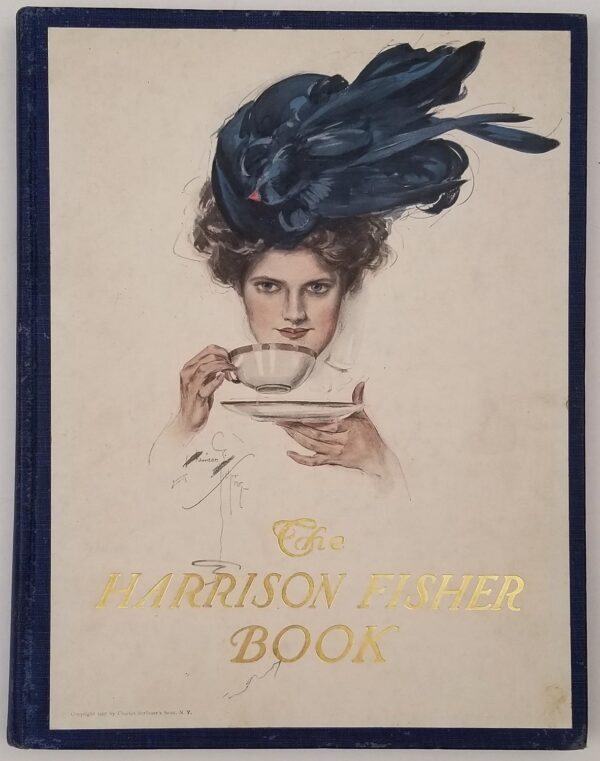
FISHER, HARRISON) Fisher, Harrison (illus).
Complete with 8 color plates plus color plate on front cover and 80 black and white full page illustrations plus black and white frontispiece, unpaginated, 11 x 9 inches, blue cloth covered boards, full size color pictorial cover label. Cover is bright, light toning to endpapers. Interior in good condition: short tear to upper layer of paper between black and white frontispiece illustration and introduction, one plate (Automobile Girl) is detached from binding and another (Fisherman's Luck) is loose with paper loss along the gutter edge. The half title page has an elaborate ink signature and miniature seascape from a previous owner. These color and black and white plates demonstrate Harrison Fisher's talents in capturing the essence of the turn of the century American Beauty, and include such images as The Bride and several of women and dogs. There is a black and white photographic portrait of Fisher and an interesting introduction by James B. Carrington "Mr Harrison Fisher's Place in American Illustration." The color plates in the volume are: Those Bewitching Eyes, American Beauties, Ready for the Run, Something more than a Diversion, Wanted - an answer, Fore!, Fisherman's Luck, Automobile and After the Dance.