Sze, Mai-Mai
Bollingen Series XLIX. With a translation of the Chieh Tzu Yuan Hua Chuan or Mustard Seed Garden Manual of Painting 1679 - 1701. 4to. Vol. I: xxii, 161 pp, b&w frontis, b&w illlus throughout, single and double folding color plates. Vol. II: xxxv, 587 pp, b&w illus throughout. Light green cloth covers with gilt titles at spine. In original cream dust jackets with green titles. Spines of dj slightly toned. Housed in original black, green, gold slipcase, somewhat marked. Otherwise clean throughout. Rowland p64; Chamberlin p1404.
Wilkes, Benjamin
A print from the first edition of this work, with hand colored plates drawn by two of the most celebrated botanical artists of the 18th century, Georg Ehret and Jacob van Huysum. The engravings show the complete life cycles and habitats of each species. Two pale moths hovering around a pair of peaches on a branch. Sml. "5?" penciled in lower right corner. 12 3/8 x 9 7/8". Engravings in original hand color, plate mark visible, printed on laid paper. Outside the plate mark in the margins, some light browning at the bottom edge and from sticky tape transference from the verso. Overall, very good, bright condition. "Benjamin Wikes was one of the most significant of the group of 18th century 'aurelians' which established British entomology in the direction it was to follow for well over a century." (Wilkinson, Benjamin Wilkes, the British Aurelian p.4). The continued title: All Drawn and Coloured in such a Manner, as to represent their several beautiful Appearances, Being copied from the Subjects themselves, and Painted on the best Atlas Paper.
Wilkes, Benjamin
A print from the first edition of this work, with hand colored plates drawn by two of the most celebrated botanical artists of the 18th century, Georg Ehret and Jacob van Huysum. The engravings show the complete life cycles and habitats of each species. Two brown moths hovering above a current berry branch. 12 3/8 x 9 7/8". Engravings in original hand color, plate mark visible, printed on laid paper. Outside the plate mark in the margins, some light browning at the bottom edge and from sticky tape transference from the verso. Overall, very good, bright condition. "Benjamin Wikes was one of the most significant of the group of 18th century 'aurelians' which established British entomology in the direction it was to follow for well over a century." (Wilkinson, Benjamin Wilkes, the British Aurelian p.4). The continued title: All Drawn and Coloured in such a Manner, as to represent their several beautiful Appearances, Being copied from the Subjects themselves, and Painted on the best Atlas Paper.
Wilkes, Benjamin
A print from the first edition of this work, with hand colored plates drawn by two of the most celebrated botanical artists of the 18th century, Georg Ehret and Jacob van Huysum. The engravings show the complete life cycles and habitats of each species. Two pale moths hovering above a fruited branch Sml. "40 penciled in lower right corner. 12 3/8 x 9 7/8". Engravings in original hand color, plate mark visible, printed on laid paper. Outside the plate mark in the margins, some light browning at the bottom edge and from sticky tape transference from the verso. Overall, very good, bright condition. "Benjamin Wikes was one of the most significant of the group of 18th century 'aurelians' which established British entomology in the direction it was to follow for well over a century." (Wilkinson, Benjamin Wilkes, the British Aurelian p.4). The continued title: All Drawn and Coloured in such a Manner, as to represent their several beautiful Appearances, Being copied from the Subjects themselves, and Painted on the best Atlas Paper.
Wilkes, Benjamin
A print from the first edition of this work, with hand colored plates drawn by two of the most celebrated botanical artists of the 18th century, Georg Ehret and Jacob van Huysum. The engravings show the complete life cycles and habitats of each species. Two brown moths hovering above a leaved branch. Sml. "22" penciled in lower right corner. 12 3/8 x 9 7/8". Engravings in original hand color, plate mark visible, printed on laid paper. Outside the plate mark in the margins, some light browning at the bottom edge and from sticky tape transference from the verso. Some light foxing and tape transference on the right side. Overall, very good, bright condition. "Benjamin Wikes was one of the most significant of the group of 18th century 'aurelians' which established British entomology in the direction it was to follow for well over a century." (Wilkinson, Benjamin Wilkes, the British Aurelian p.4). The continued title: All Drawn and Coloured in such a Manner, as to represent their several beautiful Appearances, Being copied from the Subjects themselves, and Painted on the best Atlas Paper.
Wilkes, Benjamin
A print from the first edition of this work, with hand colored plates drawn by two of the most celebrated botanical artists of the 18th century, Georg Ehret and Jacob van Huysum. The engravings show the complete life cycles and habitats of each species. Two pale orange/ pink moths hovering above a leafy branch. Sml. "86" penciled in lower right corner. 12 3/8 x 9 7/8". Engravings in original hand color, plate mark visible, printed on laid paper. Outside the plate mark in the margins, some light browning at the bottom edge and from sticky tape transference from the verso. Overall, very good, bright condition. "Benjamin Wikes was one of the most significant of the group of 18th century 'aurelians' which established British entomology in the direction it was to follow for well over a century." (Wilkinson, Benjamin Wilkes, the British Aurelian p.4). The continued title: All Drawn and Coloured in such a Manner, as to represent their several beautiful Appearances, Being copied from the Subjects themselves, and Painted on the best Atlas Paper.
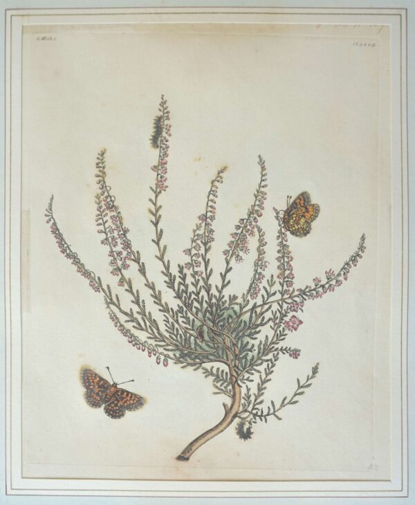
Wilkes, Benjamin
A print from the first edition of this work, with hand colored plates drawn by two of the most celebrated botanical artists of the 18th century, Georg Ehret and Jacob van Huysum. The engravings show the complete life cycles and habitats of each species. Two orange & black moths hovering above an erica or broom plant. Sml. "112" penciled in lower right corner. 12 3/8 x 9 7/8". Engravings in original hand color, plate mark visible, printed on laid paper. Outside the plate mark in the margins, some light browning at the bottom edge and from sticky tape transference from the verso. Overall, very good, bright condition. "Benjamin Wikes was one of the most significant of the group of 18th century 'aurelians' which established British entomology in the direction it was to follow for well over a century." (Wilkinson, Benjamin Wilkes, the British Aurelian p.4). The continued title: All Drawn and Coloured in such a Manner, as to represent their several beautiful Appearances, Being copied from the Subjects themselves, and Painted on the best Atlas Paper.