Women songsheet; Cartagena]
Unrecorded English Song Sheet Celebrating Admiral Vernon's Taking of Cartagena. 1741. London. 215 x 177 mm. Finely engraved song sheet, most likely prepared by English Women, and view of Cartagena (Colombia), celebrating Admiral Edward Vernon's siege against the Spanish held stronghold in April 1741, portrayed as successful, though in reality, it was a failure, a famous propaganda affair of the 18th century. Based upon information from a letter noted below, it would appear that in 1741 a series of Song sheets printed in either red or blue were issued under the heading The Ladies Amusement or Vocal Harmony. The only reference we have been able to locate for these Songs is in a letter written by William Richard Lewis of Anglesey to the Surgeon Richard Evans on October 28, 1741, where he notes: I have had a present made of late by a Gentleman coming from London of a set of Songs done on copper plate in red and blue cost 4d a piece. They are calld the Ladies Amusement or Vocal Harmony most of 'em with tunes for the flute. Mine is from plate I to VI, if they are continued I should be glad to have em This piece is docketed on the verso in manuscript: Song upon ye taking Carthagena April 1741 By Edward Vernon Esq vice admiral of ye blue. We also note a cryptic entry in a March 1760 edition of the General Evening Post (London) (see below), which may relate to these sheets. The Source The view indicates that it was printed as Plate VIII for The Ladies Amusement of Vocal Harmony. However, research into this title does reveal that such a publication actually existed. We note only that the Folger Shakespeare Library holds a single plate, described as Plate XI and titled The monument of W. Shakespeare erected in Westminster Abby [printed below]: A just satyr against ingratitude . an excellant song sung in the play As you like it . Blow, blow, thou winters wind . [etc.]. The first few lines of the song would later be repeated in a tribute to Admiral Rodney: (Admiral Rodney's triumph, or the French fleet defeated. [London]. [1782.]. 1 sheet; 1/80. British Library C.121.g.9(216). A slip-song. "True Britons all of each degree,". Adams 82-3.1. REFERENCE: ESTCT1605.) Full Text True Brittons all of each degree, Rejoice around the Nation. Full Bumpers drink and merry be Upon this just occasion Let mirth on e'ery Brow appear, Vernon Victorious is we hear, Since he's took Carthagena He with his noble Hearts of Gold, With Resolution armed, Scorning by Spain to be Contrould, This gallant Fort they Stormed, He made Don Blas peccavi cry, He sunk and burnt all he came nigh Thousands before his Arms did fly At taking Carthagena The dastard Cowards could not Stand, (When Vernon jyn'd them Battle,) The force of his Victorious Hand, The Blas did boast and rattle, When he remembred Porto Bell, His Courage quickly from him Fell, Let Fame report, I dare not Tell, That he took Carthagena. He burnt six Spanish Men of War, And six Galleons he's taken, Tho'they had Numbers odd by far, This could not save their Bacon, His Fatal Weapons play'd so fast, His Leaden Pills he made them taste, Don Blass was forc'd to yield at last, And give up Carthagena The Marrine Forces play'd their part, And like true sons of Thunder, They made the Dons from e'ery part, To truckle and knock Under They Storm'd their Forts and Castles too Their small Shot just like Hail Stones flew, The Dons could not tell what to do, But ran from Carthagena Upon the first of April last, This great Exploit he acted, This bitter Pill will make Don Blass, Nay, PHill: and Kate distracted, Brave Vernon's Health in Bumpers full Who made Don Blass an Aprill Fool, And took brave Carthagena. A rare and possibly unique survival. We note that the General Evening Post (London) of Tuesday March 25 to Thursday, March 27, 1760 includes the following advertisement on page 3, column 1: To be sold by AUCTION, (At the Horn-Tavern in Fleet-street on Tuesday next the 1st
Cacao] Navas de Carrera, Manuel
On the uses, preparation, and consumption of cacao. 1751. Zaragoza. Francisco Moreno. 4to, (200 x 145 mm). 12 ff., 63 pp. Later vellum over boards, spine lettered in ink, bound a little tight, endpapers renewed. Excellent condition overall, some scattered foxing, small restoration to the lower part of title page, two small holes at gutter at title and index, touching a letter, probably caused at the time of binding, else fine. First edition, an extremely rare and very complete and encompassing study of the properties, uses, virtues, preparation, and consumption of cacao, with a specific chapter for its use in the Indies. The book is divided into seven chapters dealing with the invention and description of the cacao tree, the use of cacao in the Indies, the qualities and temperament of cacao, a chemical analysis, the virtues of the oil butter and salt of cacao, its composition, ingredients, its preparation, etc. As above said, it is surprisingly rare, according to OCLC we can only locate copies at JCB and The New York Academy of Medicine, we were able to locate two others in CCPB in Spain. Palau, 188746; not in Sabin.

Dali, Salvador] Buñuel, Luis
Unique copy, with an original drawing by Salvador Dali. S.a. [c.1952]. Santiago de Chile. Le Grabuge. Carmelo Soria. Large folio, (370 x 260 mm). 4 ff. Original printed wrappers, some wear. Light toning, overall fine. A unique copy, presumably intervened by Salvador Dali with a double page drawing, signed by him, over the text of an important work on South American surrealist literature, art, and cinema. Characteristic of Dalis intervention of Goyas engravings, we see ink stains where we can distinguish a crown and a llama wielding a sword. In the space between the neck and the sword appears a face, a method Dali called metodo paranoico-critico, a method employed by him and Buñel for the writing of the script. The drawing bears an inscription over Dalis signature Avec Plaisir pour Le Grabuge, the editorial house of Braulio Arenas. The movie Un perro andaluz was the first by Luis Buñuel, he directed it in 1929, the script he co-wrote with Dali, and was shot in bearly 15 days. By itself a rare work, printed by Carmelo Soria in a run of 195 numbered copies, none of which appear to exist institutionally, and this particular copy, being unnumbered. Luis Buñuels text, dated December 1929, says: La publicación de este escenario en La Révolution surréaliste es la única que yo autorizo. Ella expresa sin ningún género de reserva, mi completa adhesión al pensamiento y a la actividad del surrealismo. (.). Dalí y Buñuel, figuras señeras de la influyente vanguardia surrealista, redactaron el guión con el método del cadavre exquis (cadáver exquisito), que consiste en escribir un texto colectivo a partir de frases que describan las primeras imágenes que pasen por la mente sin buscar explicarlas o racionalizarlas para luego pasar el escrito a otra persona, que escribirá otra frase inconexa, para así construir un texto que es como un montaje inconsciente sin continuidad narrativa ni explicación racional. (Román Domínguez, professor of the Instituto de Estética, PUC, Santiago de Chile). From the premier at the Studio des Ursulines en París, Un perro andaluz became a landmark of the Surrealist movement and is considered a capital work in the history of cinema, having influenced Andre Breton. Historical background: En Santiago de Chile, el guión de "Un perro andaluz" fue publicado por el sello editorial Le Grabuge, iniciativa del poeta surrealista Braulio Arenas -fundador en 1938 del grupo surrealista Mandrágora- que publicó varios títulos (3) bajo dicho sello, bautizado Le Grabuge en alusión a una proyectada revista del surrealista francés Jacques Rigaut. (4) Para la impresión de esta obra de Buñuel y Dalí, fue convocado el español Carmelo Soria Espinoza (1921 - 1976), exiliado en Chile, donde se encontraba a la caída de la Segunda República Española. Miembro del Partido Comunista de su patria, diplomático y economista; Soria Espinoza era nieto del urbanista Arturo Soria, fundador de la emblemática Ciudad Lineal madrileña. En Chile se dedicó a la actividad editorial, primero como impresor. Se casó con Laura, hija del premio nacional de literatura José Santos González Vera, y trabajó por largo tiempo en la Comisión Económica para América Latina (CEPAL). Entre 1970 y 1973 participó de la Editorial Quimantú, con el apoyo del gobierno de Salvador Allende, y en julio de 1976 -ya en el poder Augusto Pinochet- fue detenido cuando se desempeñaba como jefe del Departamento Editorial del Centro Latinoamericano de Demografía, organismo perteneciente a la CEPAL, ambas instituciones dependientes de la ONU. En plena dictadura militar chilena, aquel secuestro devino en su muerte y para disimular el asesinato, las fuerzas represoras de la Dirección de Inteligencia Nacional (DINA) lo introdujeron otra vez a su vehículo personal y lo desbarrancaron simulando un accidente. (5) Sin indicaciones en la edición, Braulio Arenas habría realizado la traducción del texto original en francés (6); se sabe que también lo hizo en
Peace treaty] [Brazil & Uruguay]
Peace treaty in the early days of Uruguay as a Republic with the Empire of Brazil. [c.1823]. Montevideo. Imprenta de los Ayllones. Y Compania. Folio, (306 x 215 mm). 3 ff. Unbound. Uncut, some marginal soiling, and damp, loss of paper to gutter of first ff., and outer margin of another one, both away from text, one small hole affecting a couple letters. 1,400 $ The treaty of peace signed by the Emperor of Brazil and the Republic of Uruguay, recently independent, which the Brazilians historically called Cis-Platina. Printed in Portuguese; it gives the articles of the treaty. This is a peculiar time, when a newly founded Republic, in order to guarantee its continued -and to that point short lived- independence, had to engage in battle and later negotiations with a recent Empire created in American grounds. Very rare.
Garcia de Nodal, Bartolome & Gonzalo de
Important account of the navigation towards the Strait of Magellan, with Teixeiras suppressed map. 1766. Madrid. 4to. 1 ff., [2], [14], 162, [2], 45 pp., engraved folding map. Contemporary limp vellum, spine lettered in ink, excellent condition. A wonderful copy, in clean and crisp condition. 9,000 $ Second edition of Nodal's important work, including Teixeira's suppressed map of the Straits of Magellan, which illustrated one of the most important discoveries in the history of world trade, the discovery of the Strait of Le Maire or, as the Nodal brothers christened it, the Strait of San Vicente. The Nodal expedition was a reconnaissance mission sponsored by King Philip III of Spain in 1619. The purpose was to confirm the recent discoveries of Jacob Le Maire and Willem Schouten of a passage from the Atlantic to the Pacific to the south of Tierra del Fuego. The expedition was led by the brothers Bartolome and Gonzalo Garcia de Nodal, who were accompanied by cosmographer Diego Ramirez de Arrellano, who served as the chief navigator. The expedition departed from Lisbon on September 27, 1618 and by January 22, 1619 the two ships entered the strait discovered by Schouten and Le Maire between Tierra del Fuego and Staten Island. The expedition named the Strait San Vicente. The pair reconnoitered the region to the south of Tierra del Fuego including the Drake Passage, before returning to Spain on July 7, 1619. Le Maire and Schouten, sponsored by independent Dutch merchants, had circumnavigated via the new-found strait from 1615 to 1617. The importance of their find lay in the fact that Spain preferred to operate a closed sea policy in the Pacific; they claimed that their ships were the only vessels allowed to ply Pacific waters. Other nations did not agree with this policy, but the difficulty and distance in passing via the Straits of Magellan prevented many from attempting to enter the Pacific. Additionally, the Straits were claimed as proprietary territory of the Dutch East India Company, which gave them a veritable monopoly over the passage and prevented non-company ships from passing through, even though the waters were seldom if ever patrolled. The new strait provided a legal avenue for ships of all nations to enter the Pacific, a situation feared by the Spanish whose ports on the western side of South America, already proven vulnerable to sacking by the likes of Francis Drake, were again at risk. The Nodal expedition was meant to provide the Spanish with vital geographic information about the crucial, yet little known, area around the Straits of Magellan. The brothers established the navigability of the passage and found the Diego Ramirez Islands, which remained the most southerly point visited by Europeans until Captain James Cook sailed in the area in 1775. The brothers subsequently published their report of the expedition, which was intended to be accompanied by a map created by Diego Ramirez de Arellano. This map was prepared with the assistance of Pedro Teixeira, a royal cosmographer of King Philip III and, after 1621, Philip IV. However, after publication, it is believed that the map was suppressed, such that most examples of the book do not include the map. Only fragments are known of Teixeira's life, although it is evident that he enjoyed royal favor and was respected as a cosmographer. This is Teixeira's earliest known work. Born in Lisbon ca. 1595 (d. 1662), Teixeira hailed from a family of cosmographers. His father, Luis, (active 1564-1613) was a royal cosmographer as well. Pedro's brother, Joao, was also a royal cosmographer before siding with Portuguese nationalists during the revolt begun in 1640. Pedro was a royal cosmographer by 1620, when he began work on this map. Other surviving works include a manuscript atlas of Spain's principal ports, which has three copies of an accompanying written description. In Spanish archives are manuscript maps of the Basque regions and Navarra, and a map of Port
American Revolutionary War].
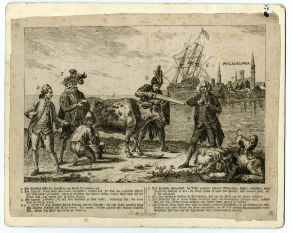
Satirical print on the American Revolutionary War. Strasbourg, c. 1780. Oblong engraving, single sheet, 286 x 218 mm, A Strasbourg in ink at foot; some spotting and staining, ink mark to upper right corner; mounted on glossy white card. 2,800 $ Uncommon variant, with explanatory text in German and seemingly printed in Strasbourg, of this print satirising the defensive alliance against Britain during the American Revolutionary Wars. It first appeared in the Westminster Magazine (Issue 6, p. 66) and was then reissued, in various forms, in America and the Netherlands (sometimes with the title A picturesque view of the state of the nation for February 1778). The use of a milk-cow was a familiar one in satirical print (as used by, say, Richard Gaywood in 1666); here, it represents British commerce, whose horns are being sawn off by the US Congress; the Dutch are cheerfully milking the cow, while the Spanish and French wait with their bowls. In the distance, we see HMS Eagle laid up near Philadelphia, with the rest of the fleet who-knowswhere, and in the foreground the British lion sleeps and is urinated on by a pug while an Englishmen tries in vain to rouse it. The image appeared in several forms, sometimes with accompanying text (and a numbered key) as here (reproducing the text in the Westminster Magazine), sometimes without. This is the only example we are aware of with the text in German. See BMSat 5726 and 5727 for related prints.
Lozano, José
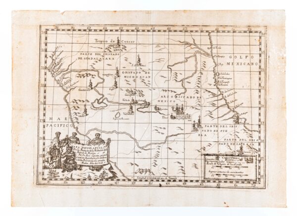
Apparently unique map of Mexico, printed in Queretaro. 1803. Queretaro. Engraved map, (419 x 304 mm). Overall in excellent condition, usual folds and scattered spotting, lone worm hole, small bit of cello tape along each edge away from printed surface, 1-inch closed tear in upper margin just entering platemark. 7,000 $ First and only edition[?], an apparently unique map printed in Queretaro, which locates the sites of the Mercedarian Order along parts of the country, made by a Mexican Mercedary Friar, later arrested for his preaching in favor of the Mexican independence. The map depicts the heart of Mexico: Zacatecas to the north, Guadalajara and the pacific to the west, Oaxaca, Veracruz and the Gulf of Mexico to the east, and Mexico and Puebla at center. Rivers, mountains, and roads are shown. Convents and hospitals are represented by small icons, as well as the college in Mexico City. The map is further embellished by a cartouche in the lower left margin, which shows five friars working with a globe and sextant. The map seems to be unique, or at least extraordinarily rare, we are unable to locate any copies of the map on OCLC original examples of this map have been traced at auction or in OCLC, although the Instituto Nacional de Antropología e Historia holds a reproduction.
American navigation] [Oyarvide, Andrés de]
Sailing directions for America, including Florida, by a seasoned sailor and cartographer, participant of the Malaspina expedition. S.a. [c.1804]. S.l. [Spain?]. Folio, (305 x 215 mm), ff. [i, contents], 59 in a neat hand, [1, blank]. Contents page, listing 12 derrotas, added later. Main body of the manuscript with contemporary watermarks throughout. Later tree-pattern sheep with a gilt border and the title Derrotas desde Cadiz á varios puertos de nuestras Americas in gilt on the upper cover. Spine very slightly worn. 20,000 $ An extremely unusual Spanish manuscript derrotero, or volume of sailing directions, to various locations in the Americas and the Philippines in which information learned from the cartographer Andrés de Oyarvide (d. 1806), active in the Malaspina Expedition (17891794), has been incorporated into the routes for sailing into the Pacific via Cape Horn and the Straits of Magellan. The derrotero is divided into two sections: the first, comprising derrotas 1 to 48, consists of the more traditional routes followed by Spanish merchantmen and naval ships to and between such locations as Veracruz, Havana, Cartagena de Indias, Santo Domingo, Florida and the Virgin Islands; the second, beginning on folio 35 and consisting of routes 49 to 54, includes the more rarely found sailing directions to and around the Pacific, particularly unusual is the final derrota from Cadiz to the Pacific via the less common course, for Spanish ships, round the Cape of Good Hope and across the Indian Ocean. The manuscript, maintaining the traditional format of such volumes as originally produced at the Casa de Contratación until its closure in 1790, is patently intended to be used as sailing directions rather than for publication. The sophistication of its content and the inclusion of such recently obtained information, however, makes it unusual and suggests that it might have been produced at the Dirección Hidrográfica, a body intended to curate, in a scientific manner, Spanish hydrographical intelligence and which largely inherited the traditional functions of the Casa de Contratación. Its author includes citations such as Cartaret and Wallis expedition, Cooks third voyage and Pedro Antonio de Cevallos 17761777 naval campaign to the Río de la Plata during the Spanish-Portuguese War as well as the published charts, the Carta Esférica del Río de la Plata desde su desembocadura hasta Buenos-Ayres. Levantada de orden del Rey en 1789 y rectificada en 1794 por varios oficiales de su Real Armada (1798) and the Carta Esférica de las Costas de la America Meridional desde Paralelo de 36° 30 de Latitud S. Hasta el Cabo de Hornos. Levantada de Orden del Rey en 1789, 90, 94 y 95 por varios Oficiales de la Armada (1798). The most striking additions to the then standard information on sailing to the Pacific which are included in this manuscript were provided by Andrés de Oyarvide from his own extensive experience in Uruguay and the Río de la Plata as well as from the surveys of the region carried out in 1789 by the Malaspina Expedition. The derroteros author, who appears to have had direct contact with Oyarvide, notes that Oyarvide was the very same subject to whom is owed the information that is being added (mismo sugeto al cual se deven las noticias que se añaden, f. 55). The author also adds that Oyarvide was at the time in the process of preparing a corrected version of the 1798 chart of the Río de la Plata (f. 55), a chart which Oyarvide completed in 1804 and which was not published until 1812. A further indication that this derrotero was produced in 1804 is a note on f.57v which states that: We have thought it best to leave the bearings marked to the compass, if wanting to correct them let it be known that the variation is 15N in the year 1804 (Hemos creido mejor el dejar las marcaciones referidas a la ahuja, queriendolas corregir sepase que la variacion es 15N el año 1804). Following his arrival in the region, Oyarvid
Jesuitica].
Jesuit mockery forbidden. 1769. Madrid. Oficina de Don Antonio Sanz. Folio, (297 x 208 mm). [2], 3, [1] pp. Unbound. Excellent condition overall, folds, scattered inconsequential foxing, worn on left edge. 1,600 $ First edition, an interesting Decree by the King of Spain forbidding the publication and circulation of an engraving titled San Ignacio de Loyola which satirized the expulsion of the Jesuits from the Spanish dominions, following their expulsion in 1767 which altered the course of events in Hispanic America. The topic of this Decree comes to show the political nature of the expulsion and the apparent discontent of the public with the Order, and at the same time the respect the Kings had for the institution, protecting them from mockery from the public. The decree was later issued in Granada, Mallorca, and other Spanish provinces. Rare in institutions in the United States, we can only locate copies at Indiana, Harvard, University of Kansas, and University of Pennsylvania; we also locate copies at BNE (Mallorca and Madrid issues), Universidad de Girona, Universidad de Granada, and Universidad de Sevilla.
Australia and Singapore; West Indies; hydrography].
Only known copy of this years publication of the Direccion de Hidrografia, with the most recent discoveries in Australia, Singapore, and the worlds Oceans. 1862. Madrid. Depósito Hidrográfico. 4to. 58 pp., 3 ff. (one with the catalogue of the maps printed by Dirección de Hidrografía in 1860-1861 and books), 2 folded maps. Contemporary red morocco with supralibros with the Spanish arms on boards, all heavily gilt in neoclassical style, gilt-edged, spine gilt with slight cracking on upper spine, edge-rolled gilt tooled doublures, marbled endpapers. Excellent condition, clean and fresh. 3,500 $ Rare, no other copy known, this is the official document where all the geographical discoveries were noted, issued one for each year, there is no other example known for this year; it contains news of discoveries in Australia, Singapore, and the Pacific. Overall this is the official document issued by the Spanish Dirección de Hidrográfíca reporting the discoveries in the world oceans in 1861. Since the 18th century the Dirección had been at the forefront of Spanish oceanic exploration and mapping. In this compilation for 1861 there are reports of discoveries around the world: the rocky seabed off Singapore on the coast of Bintan island; in Australia reefs discovered in the Strait of Torres (21-25) and of a protruding rock off the coast of the Cape of Northtumberland (25-26), buoys and beacons and tide markings (47-48,50); off the coast of New Zealand (27-30) reefs and small islands, off the coast of California also a reef; in Hawaii a correct location is given of two islands, one of them called Paltroon, (26-27). There are also sections on the Philippines (18-20) and Cuba (53-57). At the end there are two folded maps of Cuba, one representing the port of Sagua la Grande. Not in Forbes Hawaian National Bibliography. 1780-1900. Not in Ferguson Bibliography of Australia. 1784-1900. Not in Bagnall New Zealand National bibliography to the year 1960.

![Rio-Janeiro [View of Rio de Janeiro]](https://rarebookinsider.com/wp-content/uploads/2021/02/30782272036-600x489.jpg)