NAVAL INTELLIGENCE DIVISION. [GODFREY, J.H. et al.].
"For Official Use Only" FIRST EDITION. 2 vols. 8vo. (21.5 x 14 cm). pp.xiii525; xiv+514. Publisher's original orange cloth with gilt lettering to spines and upper covers. In total 264 maps and diagrams, 244 plates, and three loose folding maps in rear pockets. Some light sunning to spines, light spotting to spine of Vol. 2, generally a very good set. First and only edition of a geographical handbook to the Dutch East Indies (present day Indonesia), published on behalf of the Naval Intelligence Division (NID) of the British Admiralty. The British Naval Intelligence Division Geographical Handbook Series was produced between 1941 and 1946. At 31 titles, encompassing 58 volumes, this is the largest single body of geographical writing ever published. The books were written to provide information for the Allied war effort. They were written by academics in two teams, one based in Cambridge and the other at Oxford. As lives depended on the information presented in the Handbooks, speed of production and accuracy of content were paramount. After the war, many of these handbooks were re-published, in modified form, as textbooks. "This volume was produced and printed for official purposes during the war 1939/45". "In 1915 a Geographical Section was formed in the Naval Intelligence Division of the Admiralty to write Geographical Handbooks on various parts of the world. The purpose of these Handbooks was to supply, by scientific research and skilled arrangement, materials for the discussion of naval, military, and political problems, as distinct from the examination of the problems themselves" (Preface). Includes a very extensive index and bibliography.
WALTER, H[enry].
Original large-scale engraved map of Windsor Forest and its environs (96 x 130 cm), sectionalised, laid onto linen, and folding between drab paper endpapers into publisher's original green cloth covers stamped in blind and lettered in gilt. Embellished with decorative calligraphic title and compass rose. Later (c.1850) neat manuscript addition of local railway lines. Publisher's advertisements to front pastedown. Covers respined, map with some light tonging, some spotting visible to verso, generally a very good copy of this impressive survey. A rare separately published map of the environs of Windsor Forest from Staines in the West, Bagshot in the South, Twyford in the West and Maidenhead in the North. Walter is not recorded in Worms and Baynton-Williams. Copac lists only two institutional copies (British Library and Oxford University) and Worldcat only one (British Library). This map appears to have been reissued by Alfred E. Harrison in 1856 under the title "A Map of Windsor Forest and its Vicinity from Actual Survey by The late Henry Walter, Revised & Corrected to the Present Time". This map shows the railway lines. It is possible that the previous owner of the present map consulted the later issue to add in the railway lines by hand. "Sold by E. Mogg No. 51 Charing Cross".

COX, Percy et al.
8vo. (24 x 16cm). Original blue printed card covers. With Cox's interesting review of Ameen Rihani's book "Ibn Sa'oud of Arabia: His People and his Land" (1928), which he praises and critiques in equal measure, concluding that his book is "particularly valuable at the present time.whether Sultan 'Abdul 'Aziz, since recognized by H.M.'s Government as King of the Hejaz and of Nejd, will altogether appreciate the partial lifting of the veil from the recesses of his private life is perhaps doubtful". Numerous photographic illustrations throughout, folding map of the Valleys and Glaciers in Hunza. Light wear and soiling to covers with partial losses to extremities of spine, generally very good. Contents include the following articles: Morris, Captain C.J. - Some Valleys and Glaciers in Hunza Cameron, Lieut. D.R.G. - A Journey across the Sahara from Kano to Ouarghla Grossland, Cyril - The Islands of Tahiti Cochran-Patrick, Major C.K. - The Kabompo Gorge in Northern Rhodesia A.R.H. - Air Survey: Review P.Z.C. - The Wahhabi King: Review D.W.F. - Raymond's Map of the Alps
RAVENSTEIN, E.G.
Original lithographic map of Britain (83 x 67 cm) with fine contemporary hand-colouring, sectionalised and mounted onto linen, folding into original green cloth slipcase stamped in blind and lettered in gilt, marbled endpapers. Printed by Standidge & Co. With 16pp. pamphlet on the "Geological Structure of Great Britain" bound in. With the label of James Tennant (1808-1881), English mineralogist, the master of the Worshipful Company of Turners, and mineralogist to Queen Victoria, with his label to front pastedown. Tennant's shop at 149 Strand traded primarily in minerals and rare geological specimens until 1881. Some light dampstaining notably near title, a small tear along linen repaired with archival tape to verso, generally a very good copy with attractive colour. Using colour to great effect, the image shows the geological substrata and relative age of England and Wales, listing over 25 individual types of surface that can be found below the surface of the island. One colour of particular importance was grey, which represented the great coal measures in southern Wales and northern England that powered much of the Industrial Revolution.
CROSS, Joseph.
Large folding lithographed map of London (84 x 122 cm) with contemporary full wash colour, sectionalised and laid onto linen, paper endpapers to verso, folding into publisher's original green cloth slipcase (23 x 14 cm.) with printed title label pasted onto upper portion. Extends from Islington in the north to Camberwell in the south, and Kensington Gardens in the west to the East India Docks in the east. Old ownership inscription of G. C. Graham 1856 to endpaper and title-label. Generally an excellent copy. This large-scale plan is an unrecorded edition of Joseph Cross' first of London. It was first published in 1828 to the large scale of four and a half inches to the mile. The title label on the slipcase states that the 'whole surface of the Plan is divided into half mile squares.' The Great Western Railway Terminus is shown on the edge of the map, much of it remains to this day. Designed by Isambard Kingdom Brunel it opened in the previous year. The beginnings of the extensive railway network in London are already seen. The title on the slipcase label reads: "Cross's Large Revised Plan of London, extending from Kensington Gardens to the East India Docks, exhibiting all the New Parks, Streets, and Buildings: also shewing the Boundaries of the Metropolitan Boroughs, Parishes, and County Courts, and all the Terminuses of the Railroads". Howgego identifies 14 editions, the last being c.1864. This one dated 1855 is not listed. The 1854 edition extended the London and Southampton railway to Waterloo. Joseph Cross (c.1791-c.54) was an engraver, mapseller, and publisher. He was a founding member of the Royal Geographical Society in 1830. His son of the same name joined him in the business about 1847. Cf. Howgego (1978) 317 but this issue not listed).
APRÈS DE MANNEVILLETTE, Jean-Baptiste-Nicolas-Denis d' (1707-1780).
Original copper-engraved sea chart of Manilla (57.5 x 41.5 cm overall) printed on heavy paper. The chart extends from the North coast of Mindoro Island to north of Pointe de Capones, centered on Manilla Bay and Subec Bay. It is based on the most progressive sources available to the French Navy. European interest in Manila Bay, and the Philippines in general, was heightened upon hearing news of British Admiral George Anson's capture of a Spanish Manila Galleon off of Cabo Espiritu Santo, in 1743. A few isolated spots, generally a very good clean copy. The present chart was drafted by French sailor and hydrographer Jean-Batiste de Mannevillette (1707-80). Mannevillette apprenticed under the great royal cartographer Guillaume De L'Isle. He then joined the maritime service of the Compagnie des Indes, eventually attaining the rank of captain. Upon his return to Paris, Mannevillette was appointed as director of the Dépôt des Cartes et Plans de la Navigation des Indes. In 1745, he published the first edition of his sea atlas of Asian waters, Le Neptune Oriental, regarded as a major achievement and a library indispensable to navigators. The high quality of Mannevillette's charts won him the acclaim of both mariners and academics alike, and he was admitted as a fellow of the Academy of Sciences. He published a second, heavily revised, edition of the Neptune Oriental in 1775., from which the present chart derives.
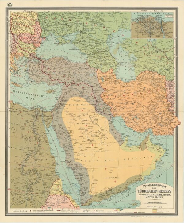
MITTELBACH.
Original large colour-printed map of the Middle East (94 x 78 cm) focussing on the Arabian Peninsula, with an inset map of the Nile Delta and Suez Canal to upper corner. Folding into publisher's original card wrappers (24 x 15.5 cm) printed in black and red. Photolithographed by Druck. One small patch of browning to Caspian Sea, otherwise an excellent copy preserved in the original wrappers. The map shows the Middle East around the time of the First World War and includes a wealth of detail including railways (including the Hejaz Railway), roads, ruins, forts, cables, steamer lines, etc. European colonial possessions are shaded in dark green (British), yellow (Italian), and orange (French).
(CHURCHILL, Winston); HUNT, Frank A. Devine.
Original colour printed map (91 x 117 cm) of the "historic wartime journeys undertaken by the Right Hon. Winston Churchill.in defence of the British Commonwelath and Empire. Folds into original card slipcase (22 x 15 cm) with pictorial front-cover". "Issued to World Book Members in April 1956" printed to back of case. Some crude tape repairs to slip-case, map in excellent condition. The routes of Churchill's wartime trips abroad are shown, noted the conferences he attended and Churchill's mode of transport. Colourful vignette portraits of the planes and ships Churchill used appear at the foot of the map and include HMS Duke of York, HMS Renown, HMT Queen Mary, and the airplanes "Commando" and "Berwick." Churchill's popular six-volume memoir The Second World War, originally published between 1948 and 1954, was reissued in a cheaper edition by the Reprint Society between 1950 and 1956 for its World Books book club. "Upon publication of the sixth and final volume of the Reprint Society edition in April 1956, the publisher issued World Books members a folded slipcased 'Map of the Historic Wartime Journeys undertaken by The Right Hon. Sir Winston Churchill, K.G., O.M., C.H. in Defence of the British Commonwealth and Empire' to commemorate the 'completion of the Reprint Society edition of the Churchill war memoirs'" (Cohen A240.6(VI).a).
FIRST EDITION. Original lithographic map of England and Wales (98 x 84 cm) with fine contemporary hand-colouring, sectionalised and mounted onto linen, folding into original blue cloth slipcase stamped in blind and lettered in gilt, publisher's yellow adverts to two panels on verso. With six cross sections. Engraved by J. &. C. Walker. Discrete stamp of the Massachusetts Institute of Technology (MIT) with a date of 1892 to upper corner just encroaching onto map. Lightly toned and some trivial signs of wear, some extensive archival tape repairs/strengthening to verso along folds, generally a very good example. A large, early hand-coloured geological map of Great Britain by Andrew Ramsay (1814 - 1891), who in 1862 became President of the Geological Society of London, and in 1872, succeeded Sir Roderick Murchison as Director-General of the Geological Survey. Several later editions were issued, this is the first issue published in 1859. Using colour to great effect, the image shows the geological substrata and relative age of England and Wales, listing over 25 individual types of surface that can be found below the surface of the island. One colour of particular importance was grey, which represented the great coal measures in southern Wales and northern England that powered much of the Industrial Revolution. Several profiles of various points along the coastline show the stratified nature of the underlying rock, but the theory of plate tectonics that allowed for such terrestrial construction wouldn't be proposed for another 50 years or so.
Original full-page tinted lithograph (c. 44 x 61 cm) printed in several colours. An excellent example. The best known and most striking of the 250 lithographic plates in Roberts' famous work on Egypt and Nubia - "the most important and elaborate ventures of nineteenth-century publishing, and.the apotheosis of the tinted lithograph" (Abbey, Travel). It captures the dramatic moment when a desert sandstorm, or simoon, approaches a caravan travelling through the desert of Gizeh in Egypt. ? ? Upon viewing an original painted version of this desert scene, a contemporary critic remarked, "the Simoon, though only a small drawing, expresses with extraordinary force and beauty the obscured sunlight dimly illuminating the wide stretch of sandy desert. Roberts's work is sometimes refined overmuch, and this example is all the more precious in expressing the strength as well as the delicacy of the painter's genius" (The Art Journal, 1874).? Roberts was the first independent, professional British artist to travel so extensively in the Near East. His tour in 1838-9 produced 272 sketches, a panorama of Cairo and three full sketchbooks, enough material to "serve me for the rest of my life" (Roberts, eastern journal, 28 Jan 1839). Over the next decade he made "a series of intire new drawings" for the large coloured lithographs executed by Louis Haghe for The Holy Land, Syria, Idumea, Arabia, Egypt & Nubia, which was originally published by subscription, 1842-9. No publication before this had presented so comprehensive a series of views of the monuments, landscape, and people of the Near East. Yesterday and Today: Egypt, 13.
Original large colour-printed map (146 x 96 cm) of Palestine backed onto cloth and folding between publisher's blue paper printed wrappers (26 x 16 cm). Throughout the map, roads, railways, caravan trails, are delineated with villages, cities, and ruined sites noted throughout. Two smaller inset maps, the Plan of Jerusalem and a Vegetation Map of Modern Palestine are provided at lower right. The bottom portion of the map features a cross section of Judea and the Dead Sea and and a cross section of Galilee and the Jordan Valley. Place names from Biblical and modern times are provided. One small brown spot to upper right corner, generally a very good clean copy. As stated in the title, this is an Orographical map, meaning it is coloured by variances in altitude from the highest point being Mt Hermon and the lowest being the greatest depth of the Dead Sea.
Original double-page engraved map (53 x 65 cm overall) focussing on Arabia and Persia, with attractive outline colour. Old ownership stamp with monogram to lower left. An excellent copy. This stunning and highly detailed double-sheet of the Greater Middle East and Arabia was originally compiled by French Geographer Adrien Hubert Brué in 1826. Ten years later, it was revised and adapted for his prestigious project, the Atlas universel de géographie physique, politique, ancienne et moderne. However, unlike most other maps from Brué's atlas, this particular chart was not included in the first expanded edition in 1830, and was only completed for the more monumental 1840 edition from which this copy derives. Like many of Brué's maps, this chart was printed by Charles Piquet of Paris. Additional stamps next to the title cartouche inform us that the original prototype was compiled as early as 1822. In 1835, the French state acquired this, but soon thereafter the Royal Geographer was working on it again. With the revisions completed in 1836, Brué had sufficiently updated his chart to be included in this grand atlas' new and most monumental edition. As is usually the case with Adrian Hubert Brué's maps, the composition is extremely well done. Both the topography and infrastructure have been represented with an impressive level of accuracy. Cities, towns, and villages are clearly marked, as are roads, rivers, and other routes. The dramatic topography of the Middle East's diverse landscapes is accentuated by hand-coloured regional borders delineating political divisions. For the Arabian Peninsula we find many place names and details that derive from essential expeditions to the region in the late 18th century. Most crucial was the Danish expedition to Felix Arabia (1761-67), in which Carsten Niebuhr compiled the most accurate maps of both the Red Sea Basin and Yemen itself. Brué's prestigious predecessor, Royal French Geographer Jean Baptiste Bourguignon D'Anville, later elaborated on these seminal maps. In the Gulf, we find early depictions of the island of Bahrain, the coastal pearling town of Fereyha (Freihat), and even an early presence of the toponym for Qatar (Catura). Near the Strait of Hormuz is Djulfar, an important coastal trading town in East Arabia and today part of the United Arab Emirates (Ras al-Khaimah). Beyond the Arabian Peninsula, Brué is equally determined to provide as comprehensive a geographical overview as possible. Anatolia, Persia, Central Asia, and Greater Syria-Palestine are all rendered with impeccable detail. Andre Hubert Brué (1786-1832) was a French geographer and cartographer. Born in Paris, he served in the French Navy, joining the Baudin expedition to the Pacific (1800-1804). After his sea service, Brué applied his navigation and charting skills to creating finely-crafted maps, which were renowned for their crisp engraving and accuracy. He drew directly on the copper of the plate, creating what he called encyprotypes. He is best known for the Atlas universal de géographie physique, politique, ancienne et moderne.
Original colour-printed panoramic view of Jerusalem (41.5 x 57.5 cm) folding between publisher's original drab card covers with explanatory pamphlet (pp.13+[5, ads]) bound in. Old stamp belonging to the Jerusalem Bookshop to front cover. Generally an excellent copy. Presented a panoramic bird's-eye view of Jerusalem, this map highlights the most prominent and significant buildings and locations with faint brown ink. Coloured lines, explained in a key at the lower left, delineate historical walls. The map includes various stamped notations, matching the colour of barbed wired boundaries that mark the territories of "Jewish Controlled" and "Arab Controlled." Additionally, there is a distinct stamp near Mt Scopus indicating "United Nations Controlled Territory," and a few other locations in between territorial boundaries labelled "No Mans Land." The accompanying booklet would have been of great use to the historian and traveller of the mid-20th century. It begins with a romanticised introduction to Jerusalem proclaiming it "the most interesting spot in the whole world," and is followed by a historical account of the Ancient Walls and the War of the Jews with a translation provided in Greek. The booklet then lists many of the religious sites throughout the city with a brief description of each. Consulate phone numbers, a list of bus routes, and pages of advertisements fill the remaining pages and covers. The Armistice Demarcation Lines of 1948 These were established as a result of the armistice agreements between Israel and its neighbouring Arab states, specifically following the Arab-Israeli War of 1948-1949 The lines marked the areas under Jewish and Arab control, reflecting the military positions at the time of the armistice. Jerusalem was divided into East and West, with the western part of the city under Israeli control and the eastern part, including the Old City, falling under Jordanian control.
Original chromolithographed map of Malaya or modern day Malaysia (87 x 67 cm), sectionalised and laid onto linen, folding between original buckram boards lettered in black. The map covers the Malay peninsula and extends from the Thai/Siamese border to Singapore. Old ownership inscription of M. Davies to upper left margin, just encroaching onto map. Some light toning and faint spotting, generally a very good copy. A scarce map, we have been able to identify only one institutional copy in the collections of the National Library Board of Singapore. The map contains a wealth of information. A key beneath the title shows railways and roads (completed and under construction), cart tracks, foot paths, state boundaries, light railways, hill hachures, and lime stone hills. Also shows are hotels, rest houses, golf courses, wireless stations, and meteorological stations. An extensive table to bottom left shows the distances from Kuala Lumpur. The Federate Malay State (better known as the F.M.S.) Survey Department (1922-1945), was established in the early 20th century to produce detailed surveys of British Malaya and the Straits Settlements. The survey department had offices in most major Malayn ports, including Singapore, Kuala Lumpur, Penang (Georgetown), and Malacca. The F.M.S. was the first official survey organisation to publish detailed scientifically produced maps of the region. The present example appears to emphasise the developing roads and infrastructure in the region. "F.M.S. Surveys No. 78 - 1933". OCLC 244419931. National Library Board, Singapore, Lee Kong Chian Reference Library, English 912.5951 FED.
Original engraved map of China(65.5 x 84 cm.) with contemporary outline hand-colour, sectionalised and laid onto linen, folding into publisher's original decorative blue cloth slip-case (22 x 14.5 cm) stamped in blind with floral patterns and title label to upper cover, publisher's adverts to verso, small paper label to spine. Some trivial toning and light offsetting, generally a very good copy of an attractive map in an especially beautiful decorative slipcase. With a key showing the area in square miles and population of each major city; a further note reads: "The length of the Great Wall is 1500 Miles, its height on the Hills is 20 feet, in the Valleys 30 ft. The length of the Great Imperial, or Treasure Canal, is 600 Miles. 170,000 Men were employed in its construction."

![[Manilla]. Plan De La Baye et Ville de Manille](https://rarebookinsider.com/wp-content/uploads/2024/07/31910516617.jpg)