Ortelius, Abraham
Eastern Balkans. "Romaniae, (quae olim Thracia dicta) Vicinorumque Regionum, uti Bulgariae, Walachiae, Syrfiae, etc. descriptio . MDLXXXIIII". Orig. copperplate engraving after G. Gastadi's map of the region. Published by A. Ortelius in Antwerp, 1584. Orig. old colouring. With great ornamental title cartouche, a sea-creature and 3 ships in the Black Sea. 36:49,5 cm (14 1/4 x 19 1/2 inch.). V. d. Broecke Nr. 159; Koeman III, map 7602:31, ed. 31:031 (1584 Latin). - A map of the Eastern Balkans between the Adriatic and the Black Sea (Romania, Bulgaria, western part of Turkey, former Yugoslavia). - Printed on paper sized 43,5:55,5 cm.

Mercator, Gerardus
North Pole (Arctic). "Polus Arcticus cum vicinis regionibus". Orig. copperplate engraving from Mercator's Atlas Minor. Published by J. Hondius, C. Claesz. a J. Jansz. in Amsterdam, 1607. A map of North Pole in oval surrounded with ornaments. With oval title-cartouche and 3 inset charts (Faeroe Islands - "Farre insulae", Shetland Islands - "Scetland insulae" and a phantom island of Frisland - "Frislant insula") in oval cartouches. 13,5:18,5 cm (5 1/4 x 7 1/4 inch.) on paper sized 17:21,5 cm. Burden, map 154; Koeman III, map 0020:351, ed. 351:01 (1607 Atlas Minor). - A very decorative miniature map of the North Pole, surrounding islands (Greenland, Island, Nova Zemla .) and the northern coasts of America (including 'California regio'!), Asia and Europe. - Nice dark impression.
Alexandre, Dom Jacques
Alexandre, Jacques (auch Jacob Alexander; 1653-1734). "Ausführliche Abhandlung Von Den Uhren überhaupt. Aus dem Frantzösischen in das Teutsche übersetzet, auch mit Anmerckungen erläutert und vermehret Von Christian Philipp Berger, Gräfl. Schaumburgis. Lippischen Land-Physico". Lemgo: J. H. Meyer, 1738. 8vo. (26), 408, (16) S. mit zahlreichenen Tabellen im Text, XXV (recte XXVII) gef. Kupfertafeln (Tafeln IX und XXIII sind zewimal eingebunden, jeweils mit unterschiedlichen Abbildungen). HLdr. aus der Zeit. Abhandlung über die Uhren und die Uhrmacherei. - Frontispiz fehlt, obere rechte Ecke des Titelblattes ca. 1x5 cm abgerissen mit geringem Verlust des Textes (letzte 3 Buchstaben des Autorennamens) und mit Papier aus dem Zeit ergänzt. Die Kupfertafeln sind nur leicht gebräunt. Sonst gut erhalten.
Mercator, Gerardus
Cyprus. "Cyprus". Orig. copperplate engraving from Mercator's Atlas Minor. Published by J. Hondius in Amsterdam, 1609. With ornamental title cartouche, another cartouche with the scale of map and 6 inset maps of Aegean Islands (Lemnos - 'Stalimini', Chios - 'Chius', Lesbos - 'Mitilene', Euboea - 'Negroponte', Kythira - 'Cerigo' and Rhodes - 'Rhodus'). 14:19 cm (5 1/2 x 7 1/2 inch.) on paper sized 17,5:21 cm. Koeman III, map 8130:351, ed. 351:21 (1609 Atlas Minor [Ger.]). - A miniature map of Cyprus and the Aegean Islands.
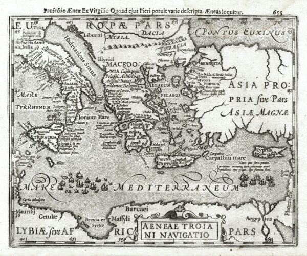
Mercator, Gerardus
Eastern Mediterranean. "Aeneae Troiani Navigatio". Orig. copperplate engraving from Mercator's Atlas Minor. Published by J. Hondius in Amsterdam, 1608. With ornamental title cartouche and title above the map ('Profectio Aenae Ex Virgillio Quoad eius Fieri potuit varie descripta. Aeneas loquitur'). 15:19 cm (6 x 7 1/2 inch) on paper sized 18:21,5 cm. Koeman III, map 0311H:351, ed. 351:11 (1608 Atlas Minor [Fr.]). - A miniature map map of Aeneas' travels in the Eastern Mediterranean - Italy, Sicily, Greece, Crete, Cyprus, Turkey.
Roth-Scholtz, Friedrich
Roth-Schlotz, Friedrich (Editor; 1687-1736). Chemie, Alchemie. "Deutsches Theatrum Chemicum, Auf welchem der berühmtesten Philosophen und Alchymisten Schriften, Die von dem Stein der Weisen, von Verwandelung der Schlechten Metallen in bessere, von Edelgesteinen, von Kräutern, von Thieren, von Gesund- und Sauer-Brunnen . Vorgestellet werden durch . Roth-Scholtzen". Nürnberg: Felsecker (Erben), 1732. 12mo. 960 S., 2 Kupferporträte (John Dee; 1527, London - 1608, Mortlake-Surrey - ein englischer Mathematiker, Astronom, Astrologe, Geograph und Mystiker vor der Seite 1 und Edward Kelley, auch Kelly; 1555, Worcester - 1597, Most, Tschechien - war ein englischer Alchemist und Spiritist vor der Seite 561), 3 Holzschnitt-Wappen. OLdr. aus der Zeit mit Titelschild auf der Rücken. Enthält alchemistische Schriften von Roger Bacon, Edward Kelley, Antonio de Abbatius und anderen, u.a. über den Stein der Weisen und die Goldherstellung, erschienen bei Felsecker, 1731: XXXI. Rogerii Baconis . Chymisch- und Philosophische Schrifften: Radix Mundi oder Wurtzel der Welt. Medulla Alchimiae, darinnen Vom Stein der Weisen, und von den vornehmsten Tincturen des Goldes, Vitriols und Antimonii, gahandelt wird. Tractat vom Golde. Tractat von der Tinctur und Oel des Vitriols. Tractat von . des Animonii. Send-Schreiben . von der Richtigkeit der falschen Magiae . XXXII. Gloria Mundi, Sonsten Paradeiß-Taffel. Alethopili Philosophische Betrachtung Von Verwandlung Der Metallen. Warnungs-Vorrede wider die Sophisten und Betrüger. Johannis Ticinensis . Johannis Ticinensis eines Böhmischen Priesters Chymische Schriften. Anthonii De Abbatia . ausgefertigtes Send-Schreiben von dem Stein der Weisen. . Anthonii De Abbatia Epistolae Duae, Scrutatoribus Artis Chymicae Mandatae. Edouardi Kellaei . Buch von dem Stein der Weisen. Edouardi Kellaei . Via Humida. Aula Lucis, Oder: das Hauß des Lichts durch S. N. ***. - Einband mit kl. Wurmlöchlein, sonst sauber und sehr gut erhalten.
Schwenter, Daniel (1585-1636) and Böckler, Georg Andreas (1617-1687). "Geometriae Practicae Novae et Auctae Libri VI. . Von neuem an Tag gegeben, und mit vielen nutzlichen Additionen und neuen Figuren vermehret durch . Georgium Andream Böcklern". Nuremberg: J. A. Endter, 1667. Smaller 4to. Engraved titel, (54), 820 (recte 816) pp. with numerous woodblock illustrations, folded copperplate behind p. 322. Full leather binding from the time with gilding on the spine. Gilt on spine faded, handwritten bookplate on title page, engraved plate slightly browned with small tear at lower left (repaired), otherwise clean and in very good condition.
East Indies (Southeast Asia). "Indiae Orientalis Insularumque Adiacentium Typus". Orig. copperplate engraving, A. Ortelius, 1570. Orig. old colouring. With ornament. title cartouche, another cartouche with explanatory notes, a coat of arms, mermaids and sea creatures (attacking a galleon in upper right corner of the map). 35:50 cm (13 3/4 x 19 3/4 inch.) on paper sized 40:53 cm. V. d. Broecke 166; Koeman III, map 8400:31, ed 31:001 (1570 Latin - first edition of Ortelius' 'Theatrum Orbis Terrarum' atlas). - Decorative map of Southeast Asia - China, India, Burma, Thailand, Laos, Cambodia, Vietnam, Japan, Malaysia, Philippines, Indonesia, part of northern Australia ('Beach, pars continentis Australis') and west coast of California ('Americae, Sive Indiae Occidentalis pars').
Eastern Balkans. "Walachia, Servia, Bulgaria, Romania". Orig. copperplate engraving after G. Mercator's map of the region. Published by J. Janssonius and H. Hondius, Amsterdam, 1638. Coloured. With decorative title-cartouche with a coat-of-arms and another cartouche with the scale of map ("Milliaria Germanica . Italica"). 34,5:47 cm (13 3/4 x 18 1/2 inch.). Koeman I, map 7602:1, ed. 1:401 (1638 Latin). - A decorative map of the eastern part of Balkan (Bulgaria, Romania, Serbia, part of Macedonia, Greece and western part of Turkey with Istanbul). - Printed on paper with wide margins sized 43,5:57 cm.
Metius, Adriaan. Mathematics, geometry. "Arithmeticae Libri Duo; et Geometriae Lib. VI. Huic adiungitur Trigonometriae Planorum Methodus succincta .". Leiden: Elzevier, 1626 and Franeker: Balck, 1625. Large 8vo. Engraved title, (14), 118, (2), 278, (3), 279-308, (1), 102 (recte 104), (14) pp., 2 folded woodblock plates. Orig. parchment binding from the time. Contains: 'Arithmeticae Liber Primus . Secundus' with many woodblock illustrations, mathematical equations and tables in the text; 'Succincta trigonometriae planorum methodus'; 'Geometriae Practicae Pars Prior . Sexta' with many woodblock illustrations and 2 folded woodblock plates. - Binding somewhat dusty. Missing copperplate after page 236 (in the 3rd part of Geometriae). Some pages in lower corner with minor water stain. Otherwise well preserved.