
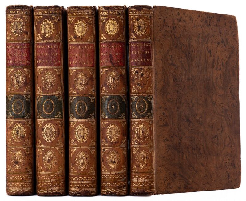
SMOLLETT, T.
The History of England from the Revolution to the Death of George the Second. (Designed as a Continuation of Mr. Hume’s History.) A New Edition, with the Author’s last Corrections and Improvements.
LondonPrinted for T. Cadell in the Strand; and R. Baldwin no 47 in Pater-Noster Row .: 1785
- $387
5 vols. 8vo. Contemporary tree-calf, smooth spines with complimenting red and green morocco labels and gilt decoration. Engraved portrait frontispiece of Smollett. Joints just starting but still holding firm, lightly rubbed along extremities, contents clean and unmarked, generally a very good set in handsome tree-calf bindings. Tobias George Smollett (1721 1771) was a Scottish novelist, surgeon, critic and playwright. He was best known for picaresque novels such as The Adventures of Roderick Random (1748), The Adventures of Peregrine Pickle (1751) and The Expedition of Humphry Clinker (1771), which influenced later novelists, including Charles Dickens. In fourteen months from 1755 to 1757 Smollett wrote his four-volume Complete History of England, making him one of the most distinguished literary men in London; he considered it to be his major work.
More from Robert Frew Ltd.

Lybian Chain of Mountains, From the Temple of Luxor.
Original tinted lithograph (44 x 61 cm) with additional later hand-colouring. Full page. Roberts was the first independent, professional British artist to travel so extensively in the Near East. His tour in 1838-9 produced 272 sketches, a panorama of Cairo and three full sketchbooks, enough material to "serve me for the rest of my life" (Roberts, eastern journal, 28 Jan 1839). Over the next decade he made "a series of intire new drawings" for the large coloured lithographs executed by Louis Haghe for The Holy Land, Syria, Idumea, Arabia, Egypt & Nubia, which was originally published by subscription, 1842-9. No publication before this had presented so comprehensive a series of views of the monuments, landscape, and people of the Near East. "Robert's Holy Land was one of the most important and elaborate ventures of nineteenth-century publishing, and it was the apotheosis of the tinted lithograph" (Abbey, Travel). Yesterday and Today: Egypt, 67. Remains of the Portico of the Temple of Kom Ombo. Nov 21st, 1839.
Original tinted lithograph (44 x 61 cm) with additional later hand-colouring. Full page. Roberts was the first independent, professional British artist to travel so extensively in the Near East. His tour in 1838-9 produced 272 sketches, a panorama of Cairo and three full sketchbooks, enough material to "serve me for the rest of my life" (Roberts, eastern journal, 28 Jan 1839). Over the next decade he made "a series of intire new drawings" for the large coloured lithographs executed by Louis Haghe for The Holy Land, Syria, Idumea, Arabia, Egypt & Nubia, which was originally published by subscription, 1842-9. No publication before this had presented so comprehensive a series of views of the monuments, landscape, and people of the Near East. "Robert's Holy Land was one of the most important and elaborate ventures of nineteenth-century publishing, and it was the apotheosis of the tinted lithograph" (Abbey, Travel). Yesterday and Today: Egypt, 46. Ruins of Kom Ombo. Nov 21st, 1838.
Original tinted lithograph (44 x 61 cm) with later additional hand-colouring. Full page. Roberts was the first independent, professional British artist to travel so extensively in the Near East. His tour in 1838-9 produced 272 sketches, a panorama of Cairo and three full sketchbooks, enough material to "serve me for the rest of my life" (Roberts, eastern journal, 28 Jan 1839). Over the next decade he made "a series of intire new drawings" for the large coloured lithographs executed by Louis Haghe for The Holy Land, Syria, Idumea, Arabia, Egypt & Nubia, which was originally published by subscription, 1842-9. No publication before this had presented so comprehensive a series of views of the monuments, landscape, and people of the Near East. "Robert's Holy Land was one of the most important and elaborate ventures of nineteenth-century publishing, and it was the apotheosis of the tinted lithograph" (Abbey, Travel). These lithographs were originally published in twenty parts, most parts containing six plates, the price for each part with coloured plates (the most expensive state) being 3 guineas. Yesterday and Today: Egypt, 46. Ruins of Karnack.
Original tinted lithograph (44 x 61 cm) with later additional hand-colouring. Full page. Roberts was the first independent, professional British artist to travel so extensively in the Near East. His tour in 1838-9 produced 272 sketches, a panorama of Cairo and three full sketchbooks, enough material to "serve me for the rest of my life" (Roberts, eastern journal, 28 Jan 1839). Over the next decade he made "a series of intire new drawings" for the large coloured lithographs executed by Louis Haghe for The Holy Land, Syria, Idumea, Arabia, Egypt & Nubia, which was originally published by subscription, 1842-9. No publication before this had presented so comprehensive a series of views of the monuments, landscape, and people of the Near East. "Robert's Holy Land was one of the most important and elaborate ventures of nineteenth-century publishing, and it was the apotheosis of the tinted lithograph" (Abbey, Travel). These lithographs were originally published in twenty parts, most parts containing six plates, the price for each part with coloured plates (the most expensive state) being 3 guineas. Yesterday and Today: Egypt, 59. Lybian Chain of Mountains, from the Temple of Luxor.
Original tinted lithograph (34 x 61 cm) with later additional hand-colouring. Full page. Roberts was the first independent, professional British artist to travel so extensively in the Near East. His tour in 1838-9 produced 272 sketches, a panorama of Cairo and three full sketchbooks, enough material to "serve me for the rest of my life" (Roberts, eastern journal, 28 Jan 1839). Over the next decade he made "a series of intire new drawings" for the large coloured lithographs executed by Louis Haghe for The Holy Land, Syria, Idumea, Arabia, Egypt & Nubia, which was originally published by subscription, 1842-9. No publication before this had presented so comprehensive a series of views of the monuments, landscape, and people of the Near East. "Robert's Holy Land was one of the most important and elaborate ventures of nineteenth-century publishing, and it was the apotheosis of the tinted lithograph" (Abbey, Travel). These lithographs were originally published in twenty parts, most parts containing six plates, the price for each part with coloured plates (the most expensive state) being 3 guineas. Dendera. Dec 7th, 1838.
Original tinted lithograph with later additional hand colouring. Full page. Print dimensions 32.5 x 49 cm, overall sheet size 43 x 61 cm. Roberts was the first independent, professional British artist to travel so extensively in the Near East. His tour in 1838-9 produced 272 sketches, a panorama of Cairo and three full sketchbooks, enough material to "serve me for the rest of my life" (Roberts, eastern journal, 28 Jan 1839). Over the next decade he made "a series of entire new drawings" for the large coloured lithographs executed by Louis Haghe for The Holy Land, Syria, Idumea, Arabia, Egypt & Nubia, which was originally published by subscription, 1842-9. No publication before this had presented so comprehensive a series of views of the monuments, landscape, and people of the Near East. "Robert's Holy Land was one of the most important and elaborate ventures of nineteenth-century publishing, and it was the apotheosis of the tinted lithograph" (Abbey, Travel). Yesterday and Today: Egypt, 79. The Pirates of Trucial Oman.
FIRST EDITION. 8vo. (22 x 14 cm). pp.256. Publisher's original black cloth, spine lettered in gilt, in the unclipped pictorial dust-jacket 7 black & white plates including frontispiece of Captain T. Perronet Thompson, and 5 maps. Light wear and soiling to dust-jacket, contents clean, generally very good. From the cover: "In his preface to the book, Lieutenant-Colonel H. Moyse-Bartlett describes The Pirates of Trucial Oman as a story set in Napoleonic times, though outside the main stream of history. It deals with four naval and military expeditions and a tragic episode in the career of a certain colourful Captain T. Perronet Thompson sailor, soldier, economist and politician. The Treaty which he drafted, interpreted and expounded, laid the foundation of Britain's strange relationship with the modern sheikhdoms of the Trucial coast. Captain T. Perronet Thompson was born in 1783 at Hull. After a notable academic career at Cambridge, he entered the Navy but subsequently served in the Army during the Napoleonic wars. At twenty-five he was appointed Governor of Sierra Leone. The humane and progressive attitudes which he tried to translate into action befriending the natives and liberating the slaves were not acceptable to the authorities, who recalled him. His promising military career ended in a disastrous expedition against the Bani Bu Ali tribe, for which he was court-martialled. This work, at once scholarly and readable, contains vivid descriptions of encounters between the pirates who were the curse of this coast and the British sailing ships of Nelson's day. As a study in miniature of the problems of British empire-rulers, The Pirates of Trucial Oman is an important contribution to military and political history. It helps to explain the present embattled situation in the Middle East and provides a useful lesson for those charged with the conversion of an empire and the evolution of a new system of international relationships." Works. The Works.Containing Additional Letters, Tracts, and Poems, not hitherto published; with Notes, and a Life of the Author, by Sir Walter Scott, Bart. Second Edition.
19 vols. 8vo. (21 x 14 cm.) Bound by Cross, Binders to the King, in half tan calf, marbled boards, spines with raised bands, richly gilt compartments, red and black labels, marbled endpapers, yellow edges. Faint traces of old oval library stamps to titles, iontents generally very clean, a most handsome set. The second edition of the best library edition. Jurgen: A Comedy of Justice. With Illustrations & Decorations by Frank C. Papé and an Introduction by Hugh Walpole.
LIMITED EDITION (3000). Large 8vo. (24 x 15 cm) pp. xvii + 325 + [4] (adverts). Original publisher's gilt deocrated black cloth, pictorial endpapers, upper edge dyed red, outer and lower edges uncut. Tipped in colour printed frontispiece, 11 full pages plates. Ex libris H. Alec Badham, engraved armorial bookplate to front pastedown endpaper. Light shelfwear, light spotting to edges and preliminaries, contents otherwise clean. Overall a very good copy. Aleister Crowley called Jurgen one of the "epoch-making masterpieces of philosophy" in 1929. Western Arabia and the Red Sea, B.R. 527 (Restricted). Geographical Handbook Series for Official Use Only.
FIRST EDITION. Thick 8vo. (21.5 x 14 cm). pp.xix+659. Publisher's original green cloth, spine and upper cover lettered in gilt. With a sticker affixed to verso of title-page reading "[T]his volume was produced and printed for official purposes during the war 1939/45". Profusely illustrated with 357 black & white photographic plates, 47 figures (including numerous folding maps, charts, and genealogical tables), and a colour-printed folding map of the Arabian Peninsula housed in rear pocket. Some light soiling to cloth, spine a bit faded, contents clean, a very good copy. First and only edition of a geographical handbook to the Arabian Peninsula and the Red Sea, published on behalf of the Naval Intelligence Division (NID) of the British Admiralty. "The text is aimed at arming British Naval officers with everything they need to know of the ways and worlds of western Arabia. They can learn the different types of myrrh; the nature and position of the port of Qunfidha in south-western Arabia; that both whooping-cough and chicken-pox 'are very common'; and that the telephone service in Saudi Arabia is 'rudimentary'" (Canton). At the end is a lengthy bibliography and some useful appendices, one containing a list of the Umayyad and Abbasid caliphs. Appendix D deals with plants of economic importance in the Arabian Peninsula, enlisting (fruit and nut)trees, medicinal plants, vegetables, spices and others, with a short comment on their usage. A Map of the British American Plantations, extending from Boston in New England to Georgia; including all the back Settlements in the respective Provinces, as far as the Mississippi.
BOWEN, Emmanuel. Original engraved map of the American colonies (24 x 28 cm) published in London at the time of the French & Indian War. It shows the territories of many Indian Tribes, along with over a dozen English and French Forts. The territory of the "Cherakees", "Chikasas" and Upper Creeks with their towns and villages, including the site of "Tanasse" from which the future state's name derived. On the Cumberland River is shown "Walkers Settlement 1750," possibly a reference to the French Lick trading outpost and Dr. Thomas Walker's 1750 exploration down the Cumberland. What was later called the Tennessee River is named the "Hugehego or Akansea R[iver]" on which an upstream "English Fort"probably Fort Loudounis indicated. Browned overall, upper margin with a few small splits and reinforcements to verso, some dampstaining also apparent to verso. A remarkable map showing several early Western Roads and numerous English and French forts east of the Alleghany and Appalachian Mountains, in the regions that would become the focal point of the French & Indian War. It was issued in the year prior to the seminal map of John Mitchell, and based largely upon the work of D'Anville. The map was issued in The Gentleman's Magazine, a British publication that helped to normalise the use of maps in support of articles and features. Founded in 1731 by the prominent London publisher Edward Cave, a pioneer in periodical journalism, the magazine continued in print for nearly two centuries, finally closing production in 1922. The publication covered a broad range of topics, from literature to politics, and, from 1739, frequently used maps as illustrations. It was also the publication which first used the word "magazine" (from the French for storehouse). Cave wanted to create a storehouse of knowledge and he employed some of London's best writers to fill his pages, including Samuel Johnson, Jonathan Swift, etc. etc.- $323
- $323
La Nuit Venetienne; Fantasio; Les Caprices de Marianne.
MUSSET, Alfred d; BRUNELLESCHI, Umberto. 4to (31 x 23 cm). pp.138+[4]. Bound in later half blue morocco over marbled boards, spine gilt, contrasting green title label, original decorative card upper cover bound in at rear. 20 full page tipped in colour illustrations by Brunelleschi Edges browned, generally a handsome copy.- $646
- $646
The Life and Opinions of Tristram Shandy. Gentleman. With Illustrations and Decorations by John Austen and an Introduction by J.B. Priestley.
STERNE, Laurence; AUSTEN, John (illus.) Large 8vo. (26 x 16 cm). pp. xvi + 557. Original publisher's gilt decorated black cloth, patterned endpapers, upper edge dyed red, outer and lower edges uncut. With original dustwrapper. Numerous black and white illustrations. Light shelfwear to dustwrapper, spotting to edges, contents generally clean. A very good copy overall.- $65
- $65
Mogg’s Map of Steam Navigation. Map of the United Kingdom of Great Britain & Ireland, with the adjacent parts of the Continent, from Amsterdam, to Paris and Brest, to which are added the tracks pursued by the Packets in their passage to the several Outports, and the Continent, thereby presenting an accurate representation of the Present State of Steam Navigation.
MOGG, Edward. Original engraved map of the British Isles (79 x 65 cm) showing the newly established steam ship routes around the coast, with fine contemporary hand-colour. Dissection into 24 sections and laid onto linen, folding into publisher's original slipcase with title-label, publisher's adverts to verso. With an inset map of the Shetland Isles. Generally an excellent copy with bright, attractive full colour.- $646
- $646
(Arabia). Tabula VI. Asiae.
FRIES, Lorenz. Original woodcut Ptolomaic map of the Arabian Peninsula (36 x 52 cm) with later hand-colouring; Latin title, text, and additional woodcut decorations to verso. The map is presented on a trapezoidal projection with parallels and meridians (forerunners of lines of longitude and latitude) enumerated in the borders. Minor reinforcements to verso on centre fold and along edges (invisible to recto), three miniscule wormholes to upper portion, generally a very handsome copy. An important early map of the Arabian Peninsula from the 1535 edition of Lorenz Fries' Geographia, itself based upon the works of Claudius Ptolemy. Originally intended not for a Ptolemy edition but for a new Chronica Mundi being written by Martin Waldseemüller, whose death c.1520 caused the project to be shelved.- $2,583
- $2,583
(The History of the Peloponnesian War). De Bello Peloponnesiaco Libri Octo, ad Optimorum Librorum fidem, Ex Veterum Notationibus Recentiorum Observationibus Recensuit, Argumentis et Adnotatione Perpetua Illustravit, Indices et Tabulas Chronologicas Adjecit, Atque de Vita Auctoris Praefatus est Francis Goeller.
THUCYDIDES. 2 volumes bound as one. 8vo. (21 x 13 cm). pp.xxxii+920. Text in Greek and Latin. Contemporary full vellum with the arms of the city of Utrecht stamped to both covers, smooth spine ruled and decorated in gilt, manuscript title "Thucydides" to upper portion, sprinkled edges. Engraved portrait of Thucydides and engraved map serving as frontispieces. Browning to both plates, contents otherwise clean and crisp, some light soiling to binding, generally a very good copy in a handsome binding, likely a prize binding made for one of the local schools. Thucydides was a fifth-century Greek and eyewitness to the long struggle (431-404 B.C.) for dominance between the warring city-states of Athens and Sparta. De bello Peloponnesiaco, or The History of the Peloponnesian War, his contemporary account of events, is one of the earliest works of historical writing.- $323
- $323
The Rape of the Lock. An Heroi-Comical Poem in Five Cantos. Written by Alexander Pope Embroidered with nine drawings by Aubrey Beardsley.
[BEARDSLEY, Aubrey]. POPE, Alexander. FIRST EDITION THUS. 4to. (26 x 19 cm). pp.47. Original gilt decorated blue cloth. Cover design and nine illustrations by Beardsley. Ex libris Annesley T. Warre with his Haldane Macfall bookplate to front paste-down. Edges browned, some light foxing mainly to early leaves, binding nright. ".one of Beardsley's most complete achievements." (John Russell Taylor). (Mason 355)- $549
- $549

Salome. A Tragedy in One Act: Translated from the French of Oscar Wilde, with Sixteen Drawings by Aubrey Beardsley.
WILDE, Oscar & BEARDSLEY, Aubrey (illustrator). 4to. (25.5 x 19 cm). pp.xviii+65+[1]+[2, ads.]. Original red cloth binding designed by Beardsley and lavishly decorated in gilt, top edge gilt, others uncut. 16 full-page plates by Aubrey Beardsley. "From the private library of the Yaegers" with their book-plate to front pastedown. An excellent, bright copy, contents remarkably clean and fresh. "If Le Morte Darthur [1893] made Beardsley known, his designs for the first edition in English of Wilde's Salomé made him notorious, and it remains the book of which most people think when his name is mentioned" (Ray).- $581
- $581

Jamoo, Kashmir and Adjacent Districts. Surveyed between the Years 1856 & 1860 under the Superintendence of the Lieut. Colonel Sir Andrew Scott Waugh Surveyor General of India and Superintendent G.T. Survey by Captain T.G. Montgomerie Engineers F.R.G.S. 1st Assistant G.T. Survey of India and the Assistants under his Orders. Scale: 4 Miles to 1 Inch.
MONTGOMERIE, Thomas George. Original large lithographed map (150.5 x 128.5 cm) annotated with a route into the Himalayas, dissected into 80 sections and backed onto linen, title to top right, inset plan to bottom left of 'Srinagar or city of Kashmir and environs', printed label of Edward Stanford 'wholesale & retail mapseller' of Charing Cross pasted at foot printed advertisements on yellow paper for 'Stanford's Maps' and 'Stanford's Atlases' visible to front and back when folded. Lithographed by 'J. & C. Walker lith.' A little foxing, some pin holes at head, ink note at head and route drawn out in red ink (see below), lower quadrant a bit more toned than the others, generally a very good example. A scarce large scale map of Jammu and Kashmir in northern India by Thomas George Montgomerie (1830 1878), executed as part of the Great Trigonometrical Survey of India under the superintendence of Sir Andrew Scott Waugh (1810 1878). Montgomerie gave K2 its name (K for Karakoram), and Waugh is credited with naming Mount Everest. This particular copy was clearly used by a near contemporary French expedition to the region. It bears the inscription 'Voyage au Cashmire [Himalaya] Légende' in red ink at the head and a route is mapped out, also in red ink, from 'Raul Pinde' to 'Lahore' (both off the map). This runs east from Muzaffarabad to Baramulla, Wular Lake, Srinagar, Anantnag, and the Warwan Valley. Here the expedition undertook a circular loop into the Himalayas some elevations are noted in red ink (e.g. '12000' at 'Sangam') before heading south to Jammu. Rarity: OCLC records only one copy in the US (University of Minnesota), one in Australia (University of Melbourne), one in Japan (National Diet Library), one in France (Bibliotheque Nationale), one in Germany (Staatsbibliothek zu Berlin), and two in the UK (Bodleian, National Library of Scotland).- $5,166
- $5,166

The History of England from the Revolution to the Death of George the Second. (Designed as a Continuation of Mr. Hume’s History.) A New Edition, with the Author’s last Corrections and Improvements.: https://rarebookinsider.com/rare-books/the-history-of-england-from-the-revolution-to-the-death-of-george-the-second-designed-as-a-continuation-of-mr-humes-history-a-new-edition-with-the-authors-last-corrections-and-improvements/
