
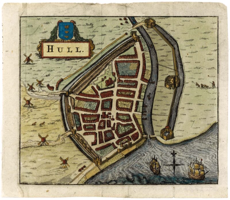
HERMANNIDES, Rutger.
Hull.
1661
- $197
Amsterdam: Aegidius Janssonius Valckenier, c.1661. Coloured. 110 x 130mm. Trimmed to printed border on left by binder, new margin added. An early miniature town plan of Kingston upon Hull, showing the outline of the streets, churches and windmills, but without naming any features. The plan was published in Hermannides's 'Magna Britannia' which contained thirty townplans mostly copied from the insets of John Speed's county maps.
More from Altea Antique Maps

A plan of the city of Edinburgh. Plan of the New Town of Edinburgh.
London, John Stockdale, 1800. Coloured. 190 x 310mm. Map of Edinburgh with a 75-point key, published in Andrews' 'Collection of Plans of the Most Capital Cities.'. In the top left corner is the layout of the New Town, with Queen St, George St & Princes St named on the map and St George Square and St Andrew's Square named in the key. Still dividing the two Towns is the Nor Loch, the polluted man-made lake drained in 1759 and now the site of the Princes Street Gardens. This work was first published in 1772, but this example is from an 1800 edition, issued during the Napoleonic Wars. Constatinopoli.
Venice: Donato Rasciotti, c.1598. 85 x 120mm. A miniature town plan of Constantinople, engraved by Martin Rota (c.1520-83) of Sebenico in Croatia in 1572. This is one of six plates signed by Rota in 'Raccolta di le piu illustri et famose Città di tutto il Mondo', a series of 322 plans of which 112 are signed by Francesco Valegio and the rest anonymous. This plate is more commonly seen in the later 1713 'Universus terrarum orbis' by Raphael Savonarola (also known as Alphonso Lasor a Varea). KING: Miniature Maps, pp.76-7.
Neueste Karte von Hindostan Bengalen etc. etc. Mit der Anzeige der Strassen, Paesse, und genauster Eitheilung der britschen Besitzungen in Ostindien Verfusst von Jakob Rennell Ingenieur Major.
Vienna: F.A. Schraemble, 1788. Original outline colour. Four sheets conjoined, total 1190 x 1460mm. Minor repairs to binding folds. A huge map of India, based on Robert Sayer's four-sheet enlarged version of James Rennell's landmark map of India of 1782, but reintroducing the original's decorative vignette of Britannia receiving a 'Shaster' ('Shastra', a Hindu book of rules). Beginning in 1764, James Rennell (1742-1830) surveyed Bengal for the East India Company under the patronage of Robert Clive & Warren Hastings, with a particular focus on the rivers, so important to trade in the absence of a regular road system, especially in the approaches to Calcutta. After over a decade of work Rennell was forced to retire, having been seriously wounded in 1766, and retired to England, where he started work on his 'atlas'. The quality of his work was such that when it was first published in 1780 (not 1779 as is often quoted because of the date on the maps) it earned him a fellowship of the Royal Society (1781) and the sobriquet 'the father of Indian cartography'. Brightstowe. Brightstowe vulgo quondam venta florentissimum Anglie emporium.
Venice: Donato Rasciotti, c.1598. 90 x 120mm. A miniature town plan of Bristol, engraved by Valegio after the Braun & Hogenberg plan of 1581 and published in 'Raccolta di le piu illustri et famose Città di tutto il Mondo'. Of the 322 plans in this series, 112 are signed by Valegio, six were reissues of plates engraved by Martin Rota in 1572, and the rest were anonymous. This plate is more commonly seen in the 1713 'Universus terrarum orbis' by Raphael Savonarola (also known as Alphonso Lasor a Varea). KING: Miniature Maps, pp.76-7. Pl. XXIII La Baleine. The Whale. Der Walfisch.
Stuttgart: Wilhelm Nitzschke, c.1856. Lithographic star chart on blue card, pierced and backed with tissue to create a transparency. Sheet 225 x 285mm. A chart of the constellation Cetus, 'The Whale', with the outline pricked out and with yellow shaped holes for the stars, so they are illuminated when the card is held up to the light. The stars are shaped to represent their apparent magnitude. From Braun's 'Himmels-Atlas in transparente Karten'. Sattalia.
BRUYN, Cornelis de. Paris: Guillaume Cavelier, 1714. 230 x 625mm. Narrow lateral margins. A view of the harbour of Antalya on the southern coast of Turkey. In 1675 the Dutch painter Cornelis de Bruyn (1652-1727) set out from Livorno on a journey through the Levant, visiting Jerusalem, Constantinople, Egypt, Greece and Cyprus. returning in 1684. His account was first published in Dutch in 1698 as 'Reizen van Cornelis de Bruyn. door Klein Asia.van Aegypten, Syrien en Palestina'. This example comes from a French edition, 'Voyage au Levant, c'est-a-dire, dans les principaux endroits de l'Asie Mineure, dans les isles de Chio, Rhodes, & Chypre &c'. On a second tour de Bruyn visited Russia, from where he travelled south to Persia then east to Java.- $289
- $289
Alexandria.
BRUYN, Cornelis de. Paris: Guillaume Cavelier, 1714. 230 x 630mm. Narrow lateral margins. A panoramic view of ruins at Alexandria, with 'Pompey's Pillar' at the centre. In 1675 the Dutch painter Cornelis de Bruyn (1652-1727) set out from Livorno on a journey through the Levant, visiting Jerusalem, Constantinople, Egypt, Greece and Cyprus. returning in 1684. His account was first published in Dutch in 1698 as 'Reizen van Cornelis de Bruyn. door Klein Asia.van Aegypten, Syrien en Palestina'. This example comes from a French edition, 'Voyage au Levant, c'est-a-dire, dans les principaux endroits de l'Asie Mineure, dans les isles de Chio, Rhodes, & Chypre &c'. On a second tour de Bruyn visited Russia, from where he travelled south to Persia then east to Java.- $289
- $289
Aleppo.
BRUYN, Cornelis de. Paris: Guillaume Cavelier, 1714. Two sheets conjoined, total 295 x 1030mm. Narrow lateral margins. A fine engraved panorama of Aleppo in Syria. In 1675 the Dutch painter Cornelis de Bruyn (1652-1727) set out from Livorno on a journey through the Levant, visiting Jerusalem, Constantinople, Egypt, Greece and Cyprus. returning in 1684. His account was first published in Dutch in 1698 as 'Reizen van Cornelis de Bruyn. door Klein Asia.van Aegypten, Syrien en Palestina'. This example comes from a French edition, 'Voyage au Levant, c'est-a-dire, dans les principaux endroits de l'Asie Mineure, dans les isles de Chio, Rhodes, & Chypre &c'. On a second tour de Bruyn visited Russia, from where he travelled south to Persia then east to Java.- $892
- $892

Magnae Britanniae et Hiberniae Tabula.
HONDIUS, Jodocus II. Amsterdam: Henricus Hondius, 1633, German text edition. Coloured. 380 x 510mm. A superb and detailed map of the British Isles, with three attractive Baroque title cartouches with swags and putti, one holding an inset of the Orkneys, the other two for the scale and title. This map was engraved in 1617 by the son of the Jodocus Hondius who engraved John Speed's county maps. Published separately, it originally had borders with ten costume vignettes and fourteen town plans, and is known by only two examples. In 1631 Jodocus's brother Henricus cut the borders off the printing plate so that it would fit into an atlas, adding his name and date, and issuing it in an 'Appendix' that year. This example comes from the next complete edition of the Mercator/Hondius two-volume atlas, 1633. SHIRLEY No. 435; KOEMAN: 1:311.1.- $1,443
- $1,443

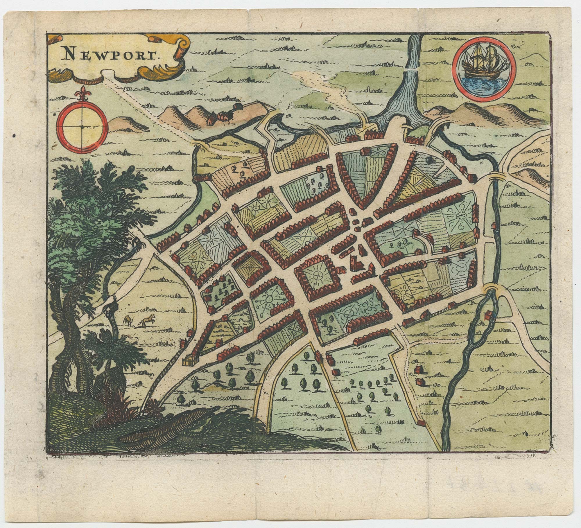
Newport.
HERMANNIDES, Rutger. Amsterdam: Aegidius Janssonius Valckenier, c.1661. Coloured. 110 x 130mm. An early miniature town plan of Newport showing the outline of the streets and churches but without naming any features. The plan was published in Hermannides's 'Magna Britannia' which contained thirty townplans mostly copied from the insets of John Speed's county maps.- $210
- $210

Staffordia. Stafford
HERMANNIDES, Rutger. Amsterdam: Aegidius Janssonius Valckenier, c.1661. Coloured. 110 x 130mm. Stitch holes to right margin. An early miniature plan of Stafford showing the outline of the streets and churches but without naming any features. The plan was published in Hermannides's 'Magna Britannia' which contained thirty townplans mostly copied from the insets of John Speed's county maps.- $164
- $164

Leicestria, Leic?ter.
HERMANNIDES, Rutger. Amsterdam: Aegidius Janssonius Valckenier, c.1661. Coloured. 110 x 130mm. A miniature town plan of Leicester showing the outline of the streets and churches but without naming any features. The plan was published in Hermannides's 'Magna Britannia' which contained thirty townplans mostly copied from the insets of John Speed's county maps.- $171
- $171

