

SPEED, John
The Kingdome of Persia with the cheef Citties and Habites described. by Iohn Speede.
Are to be sold in pops-head alley by G. Humble, 1626, [but 1627-1632]., [London],: 1626
- $2,343
Speed's map of Persia Double-page engraved map with hand-colour. A map of 'the Kingdome of Persia' (encompassing much of modern-day Iran, and parts of Saudi Arabia and Iraq), from the first atlas compiled and published by an Englishman, Speed's 'Prospect'. A decorative border along the top of the map depicts major cities. Along each side are illustrated people of different status and from different regions. Accompanying text in English, 'The Description of the Kingdome of Persia', is printed on the reverse. John Speed (1552-1629) was the outstanding cartographer of his age. By trade a merchant tailor, but by proclivity a historian, it was the patronage of Sir Fulke Greville, poet and statesman, that allowed him to pursue this interest in earnest. His 'Theatre of Great Britain', first published in 1611 or 1612, was the first large-scale printed atlas of the British Isles. The 'Prospect of the Most Famous Parts of the World', from which the present work is drawn, appeared in 1627, bound with the 'Theatre', and is the first world atlas compiled by an Englishman to be published in England. Engraved in Amsterdam, many of the maps are anglicized versions of works by Dutch makers in distinctive carte-à-figure style, featuring borders with figures in local costume and city views. Chubb, XXV; Shirley [Atlases], T.SPE-2a.
More from Daniel Crouch Rare Books LLP
Abbildung Session des Parlaments zu Londen uber den Sententz des Grafen von Stafford.
The trial of the Earl of Strafford Etched print. The case agains Thomas Wentworth, Earl of Strafford, is the focus of several prints by Wenceslaus Hollar. The present examples depicts Strafford's trial in the House of Lords, which came about after his long-term opponent John Pym brought the case for impeachment to the House on November 11, 1640. Although Strafford went in person to confront his accusers, he was immediately withdrawn and taken into custody; he was held in the Tower of London for the subsequent months. Eventually the impeachment charge failed and so Parliament passed a bill of attainder allowing Strafford to be charged and executed on May 12, 1641. Hollar's print shows the packed House of Lords during Stafford's trial, with a 25-point alphabetical key identifying various figures and features shown, such as the king's "Seate of State", "P. the Earls, Q. the Viscounts, R. the Barons, S. the Knights", and naturally "V. the Earle of Strafford", standing in a raised box and facing away towards the top of the House. Interestingly, the clerks seems to be making their notes on the floor. The present example is the second state, which was included in the 'Theatrum Europaeum' of J.P. Abelin published in Frankfurt in 1643. Abelin added a German title above the print, in which the defendant is named Earl "Stafford" rather than Strafford. New Hollstein German 330 I; Pennington 551ii. 270 by 300mm. (10.75 by 11.75 inches). Plate size: 254 by 275mm. A Map of Russia
SPEED, John Speed's map of Russia Double-page engraved map with hand-colour. A map of Russia, one of the nine new maps added to the 1676 edition of Speed's 'Prospect', the first atlas compiled and published by an Englishman. Unusually, this map is not in the carte-à-figure style that characterizes the 'Prospect'. Instead, set in the top left-hand corner of the map is a detailed plan of Moscow, with points of particular interest (such as 'The Emperours Palace' and 'The Horse market') labelled. On the right-hand side is an elaborate cartouche containing views, including 'Archangel' (Arkhangelsk) and 'A Hott House'. Accompanying text in English, 'The Description of Russia', is printed on the reverse. John Speed (1552-1629) was the outstanding cartographer of his age. By trade a merchant tailor, but by proclivity a historian, it was the patronage of Sir Fulke Greville, poet and statesman, that allowed him to pursue this interest in earnest. His 'Theatre of Great Britain', first published in 1611 or 1612, was the first large-scale printed atlas of the British Isles. The 'Prospect of the Most Famous Parts of the World', from which the present work is drawn, appeared in 1627, bound with the 'Theatre', and is the first world atlas compiled by an Englishman to be published in England. Engraved in Amsterdam, many of the maps are anglicized versions of works by Dutch makers in distinctive carte-à-figure style, featuring borders with figures in local costume and city views. This map is from the 1676 edition of the 'Prospect', published by Thomas Bassett and Richard Chiswell. While not as rare as the earlier publications, this edition is perhaps the most important, given that it is the first to include the nine new maps: among them, Virginia and Maryland, Barbados, and the present example Russia. It is also the last time that the 'Prospect' was printed as an atlas. Shirley [Atlases], T.SPE-2f.- $2,603
- $2,603
America with those known parts in that unknowne worlde both people and manner of buildings Discribed and inlarged by I.S. Ano. 1626.
SPEED, John "The first [map] published in an atlas to depict California as an island, and an accurate east coast of North America" (Burden) Double-page engraved map. The first map published in an atlas to depict California as an island, from the first atlas compiled and published by an Englishman, Speed's 'Prospect'. For this map, Abraham Goos "drew on his engraving of North America in 1624, and the Briggs 1625, to depict California as an island once more. He was the only Dutch cartographer to do so for some considerable time. There are five fewer placenames in California than the Briggs. However, like his earlier one he includes a similar faint north-west coastline and Strait of Anian. Brasil and Frisland, remnants from the sixteenth century, make a stubborn appearance in the North Atlantic. The fledgling colonies of Plymouth in New England, and Iames Citti in Virginia, are both recognised" (Burden). Vignettes in the border at the top of the map depict bird's-eye views of important towns, among them 'S. Domingo' and 'Olinda'. Illustrated in the borders along the left-side of the map are figures from North America, and from South America on the right. Accompanying text in English, 'The Description of America', is printed on the reverse. John Speed (1552-1629) was the outstanding cartographer of his age. By trade a merchant tailor, but by proclivity a historian, it was the patronage of Sir Fulke Greville, poet and statesman, that allowed him to pursue this interest in earnest. His 'Theatre of Great Britain', first published in 1611 or 1612, was the first large-scale printed atlas of the British Isles. The 'Prospect of the Most Famous Parts of the World', from which the present work is drawn, appeared in 1627, bound with the 'Theatre', and is the first world atlas compiled by an Englishman to be published in England. Engraved in Amsterdam, many of the maps are anglicized versions of works by Dutch makers in distinctive carte-à-figure style, featuring borders with figures in local costume and city views. Burden, 217; Chubb, XXV; Tooley, pg. 113; Shirley [Atlases], T.SPE-2a.- $4,556
- $4,556
Cornwall
SPEED, John Speed's map of Cornwall Double-page engraved map with hand colour. A map of Cornwall from one of the Overton editions of the first large-scale atlas of the British Isles, Speed's 'Theatre'. In the top left-hand corner is a prospect of 'Launceston or Ancient Dunhevet'. Along the right-hand side of the map four antiquities are illustrated, including the Hurlers Stones, which, according to legend, are men petrified for playing hurling on a Sunday. The sea around the peninsula is filled with sea-monsters and ships. John Speed (1552-1629) was the outstanding cartographer of his age. By trade a merchant tailor, but by proclivity a historian, it was the patronage of Sir Fulke Greville, poet and statesman, that allowed him to pursue this interest in earnest. His 'Theatre of Great Britain', from which the present work is drawn, was first published in 1611 or 1612 and is 'the earliest English attempt at atlas-production on a grand scale' (Skelton). Drawing heavily on the work of Saxton and Norden, little of Speed's cartography is original (he acknowledges, 'I have put my sickle into other mens corne'), instead it is his blend of cartography and history, incorporating town-plans, vignettes, and genealogy, that makes Speed an innovator. This map is from one of the editions of the 'Prospect' published by Henry Overton between ca. 1710 and 1743. Unlike in earlier editions, the verso of the maps tend to be blank.- $1,822
- $1,822
The Invasions of England and Ireland With al their Civill Wars Since the Conquest.
SPEED, John Speed's battle map Double-page engraved map with hand-colour. A map of England, Wales, and Ireland illustrating the invasions and battles that had played out in these countries, up until the point of the map's production, from the first atlas compiled and published by an Englishman, Speed's 'Prospect'. Deriving from an earlier map by Speed, ca. 1601, the map is peppered with vignettes that depict battles from Todcaster, to Blackheath, to Cardigan. Along the English Channel is illustrated the progress of the Spanish Armada, in 1588, from the inception of their 'pretensed invasion', to their defeat, driven up round Scotland, and 'forced about the coasts of Ireland to their contrye'. In the bottom left-hand corner is an inset text that explains the sites in Ireland, numbered for ease of reference. Accompanying text in English, 'A Briefe Description of the Civill Warres, and Battails fought in England, Wales, and Ireland', is printed on the reverse. John Speed (1552-1629) was the outstanding cartographer of his age. By trade a merchant tailor, but by proclivity a historian, it was the patronage of Sir Fulke Greville, poet and statesman, that allowed him to pursue this interest in earnest. His 'Theatre of Great Britain', first published in 1611 or 1612, was the first large-scale printed atlas of the British Isles. The 'Prospect of the Most Famous Parts of the World', from which the present work is drawn, appeared in 1627, bound with the 'Theatre', and is the first world atlas compiled by an Englishman to be published in England. Engraved in Amsterdam, many of the maps are anglicized versions of works by Dutch makers in distinctive carte-à-figure style, featuring borders with figures in local costume and city views. Chubb, XXV; Shirley [Atlases], T.SPE-2a.- $1,953
- $1,953
A Newe Mape of Germany Newly Augmented by: Iohn Speed. Ano. Dom: 1626.
SPEED, John Speed's map of Germany Double-page engraved map with hand-colour. A map covering Germany and parts of present-day Austria, from the first atlas compiled and published by an Englishman, Speed's 'Prospect'. A decorative border along each side shows figures dressed in regional costume, and, along the top, views of major cities. Accompanying text in English, 'The Description of Germany', is printed on the reverse. John Speed (1552-1629) was the outstanding cartographer of his age. By trade a merchant tailor, but by proclivity a historian, it was the patronage of Sir Fulke Greville, poet and statesman, that allowed him to pursue this interest in earnest. His 'Theatre of Great Britain', first published in 1611 or 1612, was the first large-scale printed atlas of the British Isles. The 'Prospect of the Most Famous Parts of the World', from which the present work is drawn, appeared in 1627, bound with the 'Theatre', and is the first world atlas compiled by an Englishman to be published in England. Engraved in Amsterdam, many of the maps are anglicized versions of works by Dutch makers in distinctive carte-à-figure style, featuring borders with figures in local costume and city views. Chubb, XXV; Shirley [Atlases], T.SPE-2a.- $2,343
- $2,343
Italia Newly Augmented by I: Speede.
SPEED, John Speed's map of Italy Double-page engraved map with hand-colour. A map of Italy, Sardinia, and Corsica from the first atlas compiled and published by an Englishman, Speed's 'Prospect'. The decorative border along the top of the map shows views of major cities, including Venice, Rome, and Florence. Along each side are depicted figures in regional dress (among them, the Pope and the Venetian Doge). Unlike the other maps in the 'Prospect', the figures are presented in pairs, interspersed with the arms of the Pope, Venice, Sardinia, and Corsica. Accompanying text in English, 'The Description of Italy', is printed on the reverse. John Speed (1552-1629) was the outstanding cartographer of his age. By trade a merchant tailor, but by proclivity a historian, it was the patronage of Sir Fulke Greville, poet and statesman, that allowed him to pursue this interest in earnest. His 'Theatre of Great Britain', first published in 1611 or 1612, was the first large-scale printed atlas of the British Isles. The 'Prospect of the Most Famous Parts of the World', from which the present work is drawn, appeared in 1627, bound with the 'Theatre', and is the first world atlas compiled by an Englishman to be published in England. Engraved in Amsterdam, many of the maps are anglicized versions of works by Dutch makers in distinctive carte-à-figure style, featuring borders with figures in local costume and city views. Chubb, XXV; Shirley [Atlases], T.SPE-2a.- $3,254
- $3,254
The Countye Palatine of Chester with that most ancient citie described.
SPEED, John Speed's Map of Cheshire Double-page engraved map with hand-colour, some discolouration to margins and to left and right of image. A map of Cheshire from the 1676 edition of the first large-scale atlas of the British Isles, Speed's 'Theatre'. In the top-centre of the map is an inset town-plan of Chester, with four coin medallions, possibly showing: Julius Caesar, the emperor Vespasian, the emperor Domitian, and the 20th Legion (which was among those to invade Britain with Claudius in 43CE). Along the left-hand side of the map are depicted the arms of the Earls of Chester since the Norman Conquest, among them 'Ranulph Blundeuill' and 'Ranulph Gernones'. John Speed (1552-1629) was the outstanding cartographer of his age. By trade a merchant tailor, but by proclivity a historian, it was the patronage of Sir Fulke Greville, poet and statesman, that allowed him to pursue this interest in earnest. His 'Theatre of Great Britain', from which the present work is drawn, was first published in 1611 or 1612 and is 'the earliest English attempt at atlas-production on a grand scale' (Skelton). Drawing heavily on the work of Saxton and Norden, little of Speed's cartography is original (he acknowledges, 'I have put my sickle into other mens corne'), instead it is his blend of cartography and history, incorporating town-plans, vignettes, and genealogy, that makes Speed an innovator. This map is from the 1676 edition of the 'Theatre', published by Thomas Bassett and Richard Chiswell. Interestingly, this map lacks the text in English that is usually printed on the verso. Chubb, CIV; Shirley [Atlases], T.Spe-1j; Skelton, 92.- $1,041
- $1,041
The Kingdome of Denmarke Performed by I. S.
SPEED, John Speed's map of Denmark Double-page engraved map. A map of 'the Kingdome of Denmarke', comprising modern-day Denmark, and parts of Sweden and Germany, from the 1676 edition of the first atlas compiled and published by an Englishman, Speed's 'Prospect'. The upper border contains views of major cities, including Copenhagen and Hamburg, with the arms of Christian, King of Denmark, at the centre, and portrait medallions of Christian IV and of his son and heir, Frederick, on either side. Along each side are illustrated figures wearing regional costumes. Accompanying text in English, 'The Description of the Kingdom of Denmark', is printed on the reverse. John Speed (1552-1629) was the outstanding cartographer of his age. By trade a merchant tailor, but by proclivity a historian, it was the patronage of Sir Fulke Greville, poet and statesman, that allowed him to pursue this interest in earnest. His 'Theatre of Great Britain', first published in 1611 or 1612, was the first large-scale printed atlas of the British Isles. The 'Prospect of the Most Famous Parts of the World', from which the present work is drawn, appeared in 1627, bound with the 'Theatre', and is the first world atlas compiled by an Englishman to be published in England. Engraved in Amsterdam, many of the maps are anglicized versions of works by Dutch makers in distinctive carte-à-figure style, featuring borders with figures in local costume and city views. This map is from the 1676 edition of the 'Prospect', published by Thomas Bassett and Richard Chiswell. While not as rare as the earlier publications, this edition is perhaps the most important, given that it is the first to include the nine new maps: among them, Virginia and Maryland, Barbados, and Russia. It is also the last time that the 'Prospect' was printed as an atlas. Shirley [Atlases], T.SPE-2f.- $1,172
- $1,172
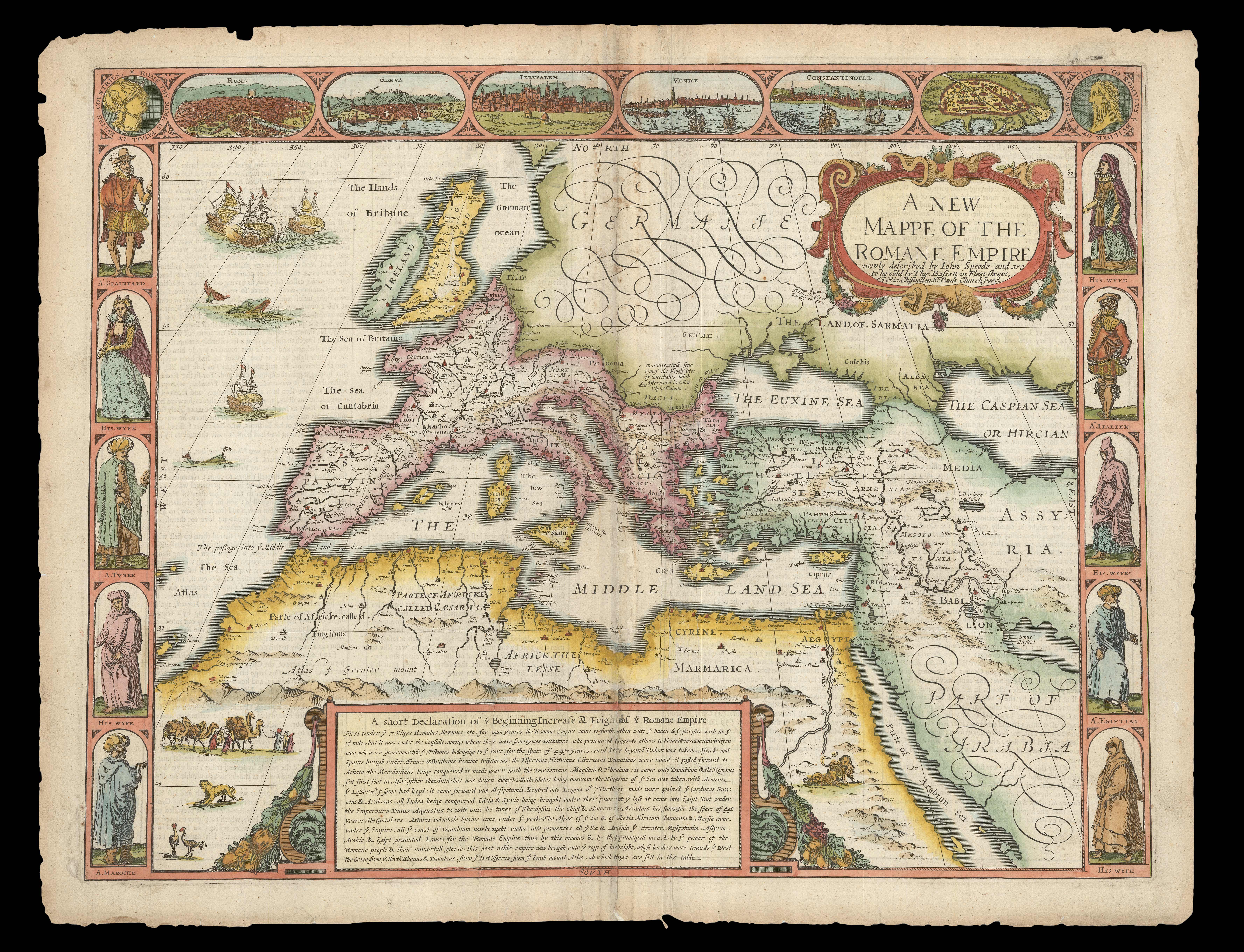
A New Mappe of the Romane Empire newly described by Iohn Speede.
SPEED, John Speed's map of the Roman Empire Double-page engraved map with hand-colour. A map showing the historical extent of the Roman Empire from the 1676 edition of the first atlas compiled and published by an Englishman, Speed's 'Prospect'. The decorative border along each side depicts men in regional costume from former imperial countries (for example, 'A Spainyard'), with 'His Wyfe' illustrated in the panel below. Along the top of the map is a series of city views. Among these is Venice, despite the fact that it was not founded until 421 C.E. and, as such, post-dates the heyday of Rome. A cartouche at the lower edge provides a potted history of the foundation and expansion of the Roman Empire. In the top left-hand corner is a medallion portrait of Roma, the personification of Rome, and in the top right-hand corner is Romulus, legendary founder of the city. Accompanying text in English, 'The Description of the Roman Empire', is printed on the reverse. John Speed (1552-1629) was the outstanding cartographer of his age. By trade a merchant tailor, but by proclivity a historian, it was the patronage of Sir Fulke Greville, poet and statesman, that allowed him to pursue this interest in earnest. His 'Theatre of Great Britain', first published in 1611 or 1612, was the first large-scale printed atlas of the British Isles. The 'Prospect of the Most Famous Parts of the World', from which the present work is drawn, appeared in 1627, bound with the 'Theatre', and is the first world atlas compiled by an Englishman to be published in England. Engraved in Amsterdam, many of the maps are anglicized versions of works by Dutch makers in distinctive carte-à-figure style, featuring borders with figures in local costume and city views. This map is from the 1676 edition of the 'Prospect', published by Thomas Bassett and Richard Chiswell. While not as rare as the earlier publications, this edition is perhaps the most important, given that it is the first to include the nine new maps: among them, Virginia and Maryland, Barbados, and Russia. It is also the last time that the 'Prospect' was printed as an atlas. Shirley [Atlases], T.SPE-2f.- $1,953
- $1,953
